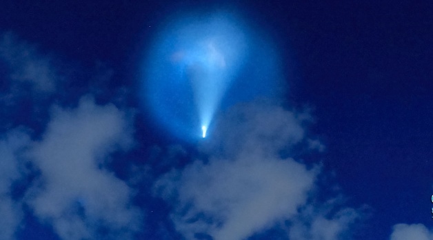
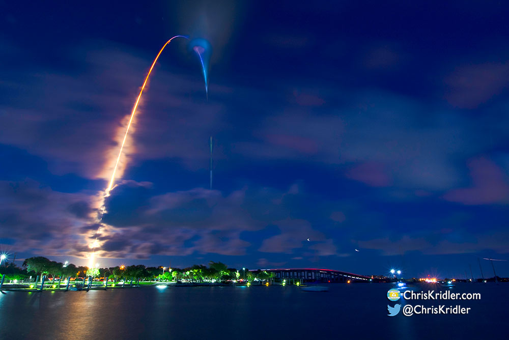
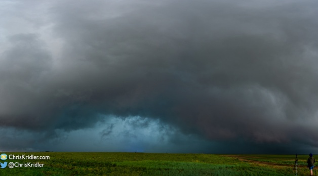
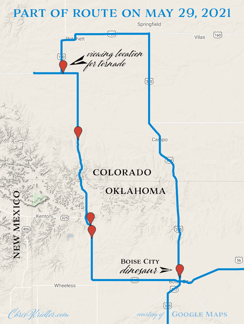
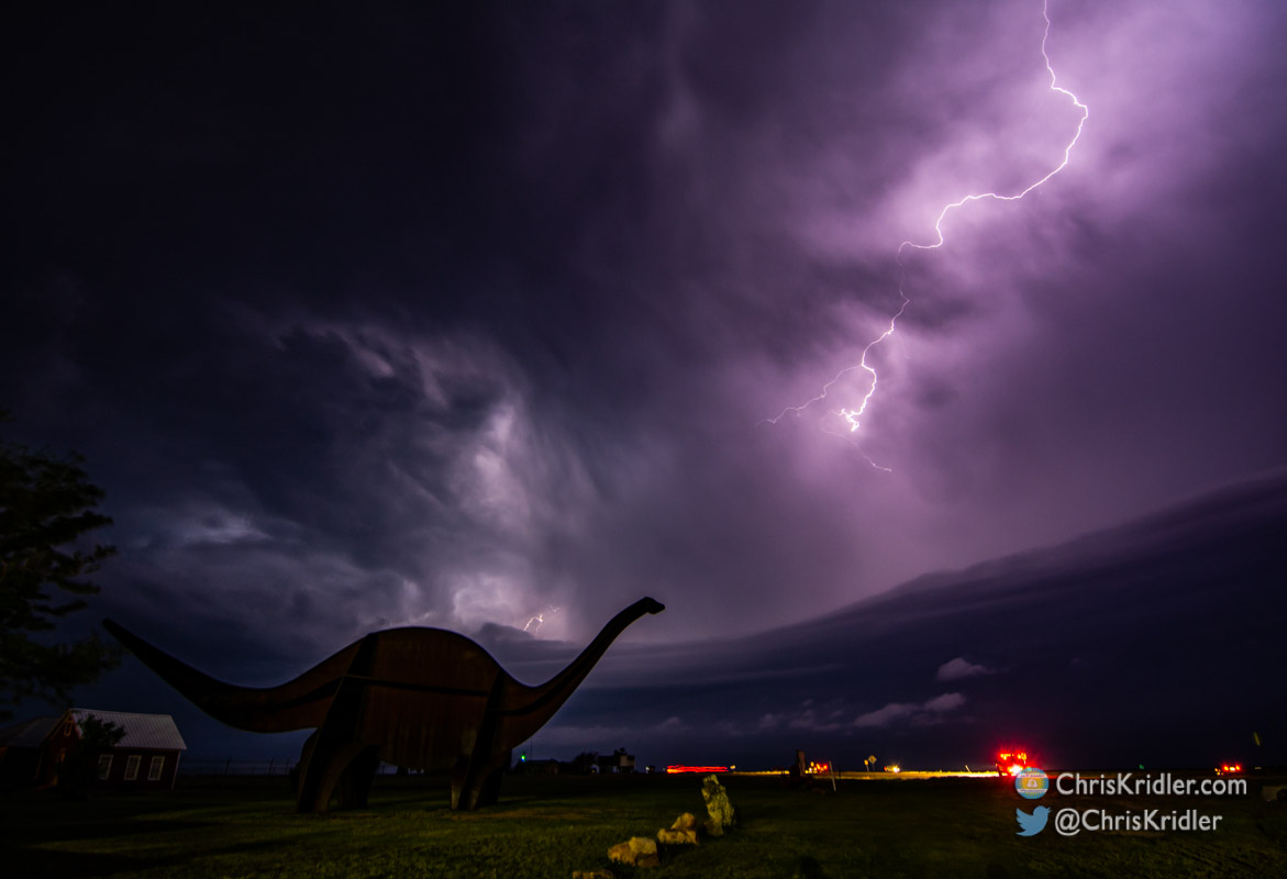
I have just made the most spectacular photo (above) and an additional shot available in my online photo gallery for print orders. Both are available in various formats, including canvas, metal and fine art prints.
This was one of those spontaneous “gentlemen’s chases” (or lady’s chase) just a few minutes from home on Florida’s Space Coast that resulted in one of the most spectacular lightning photos I’ve ever captured.
A small, isolated storm was headed toward Cocoa, Florida, on September 28, 2016, not far from my home. At first I thought I might try to intercept it along the water somewhere, but I realized this might be the chance to get lightning with the Cocoa water tower (I’d tried before). I stopped at one location but was frustrated by the trees, so I thought I’d take a chance and see if the storm would cooperate and drop lightning close enough to the tower that I could capture it if I was right across the street.
For a while, it seemed the storm was dying, and then it pulsed up with stunning results. I posted the most insane of these lightning flashes on Facebook, and it went viral, with a few of the usual “this is Photoshopped” skeptics chiming in. The only “Photoshopping” on that photo was the kind of minimal adjustments to contrast and reduction of highlights that photographers do on all photos. The exposure was nearly perfect, so I made minimal adjustments later (bringing down the slight overexposure of the bright-white water tower) and trimmed a thin slice off the right edge to achieve 4×5 dimensions. Settings: ISO 100, f/11, 11 seconds.
In fact, this is one of the more perfect lightning exposures I’ve ever achieved. Luck, experience, patience and perseverance all played a role. You can read about how the chase and photos evolved in the captions below, with settings.
Roll over each image to see the caption, or click on one to see a slide show with larger photos. Interested in prints? Learn more.
Kathy Velasquez and I targeted southwestern Kansas on May 24, 2016, and saw one of the most extraordinarily prolific tornado-producing storms of my career south of Dodge City, Kansas.
We also met up with or chased in the vicinity of chase friends Stephen Barabas, Scott McPartland, Dave Lewison, Jaclyn Whittal, George Kourounis, Mark Robinson, Bill Hark, Jason Persoff, Robert Balogh and John Mann – and a couple hundred other chasers!
We actually lost count of the tornadoes. Getting close was a challenge because of muddy roads, but the wide shots of the structure with the tornado were glorious, especially since it missed the bulk of Dodge City. And the day ended with even more spectacular skies, including a dazzling mammatus show.
Roll over each image to see the caption, or click on one to see a slide show with larger photos.
Kathy Velasquez and I targeted the north-central Texas Panhandle on May 22. Two tornadoes, including a large one that went from a wedge/fat cone to a multivortex beast, were the payoff for a crazy day of colliding storms and camera issues. And we got to film while being blasted with wind and rain and dodging peril as rear-flank downdraft winds knocked down telephone poles (watch the video for the grungy results).
Photography was challenging to say the least, but it was a visceral experience in person.
Roll over each image to see the caption, or click on one to see a slide show with larger photos.
On May 21, Kathy Velasquez and I focused our chase target to Leoti, Kansas, along with legions of other chasers, and were treated to a stunning supercell with amazing structure.
We barely saw the first tornado and missed the others but chose to hang back and appreciate this rare beauty of a storm rather than tangle with the rain. This supercell ranks among my favorite storms of all time for its beauty.
Roll over each image to see the caption, or click on one to see a slide show with larger photos.
On May 18, Kathy Velasquez and I aimed for the point where extreme western Texas met New Mexico, in the only warm air on the front that wasn’t in Mexico.
We went to El Paso and then north into New Mexico to chase the storms there. As a bonus, we saw a variety of scenery along the way.
Roll over each image to see the caption, or click on one to see a slide show with larger photos.
May 14, 2016, was a down day for chasing storms, so a great day to attend the event in Wakita, Oklahoma, celebrating the 20th anniversary of the movie “Twister.”
In the film, the town is destroyed by a tornado. During this event, storm chasers drove through town in an impromptu parade, as you can see in the video.
Roll over each image to see the caption, or click on one to see a slide show with larger photos.
Sometimes, as a storm chaser, I take a chance on a marginal forecast rather than chase a higher likelihood of severe storms in a place I don’t want to chase.
On May 11, I targeted an area with decent upper-level winds and dewpoints – where Colorado meets the Oklahoma Panhandle and the northern Texas Panhandle. I refined the target to a storm coming out of New Mexico, and after driving in a rather frustrating loop (road network issues), I ended up in front of a storm coming out of Clayton, New Mexico, that just got prettier and stronger until it ended up being warned as severe.
This storm and its sister storm had incredible lightning that I chased all the way back to Amarillo.
Roll over each image to see the caption, or click on one to see a slide show with larger photos.
Note: This post has been updated with a gallery and information moved from the old chase log at SkyDiary.com.
I’ve had three chase days and a day “off” (to work) this Tornado Alley trip, and two of the chase days found me in front of tornadoes I could not have imagined. In fact, the first tornado I saw on Monday was the most dramatic in my 20 seasons of chasing – or at least compares to the 12 May 2004 chase in Attica, Kansas, that saw a house destroyed.
Unfortunately, several houses were damaged or destroyed by the EF4 (upgraded from EF3) tornado I saw near Elmore City, Oklahoma, on Monday, and it killed one man. A hundred feelings rushed through me as I watched the tornado get close to my location on a hill in the difficult-to-chase, tree-filled terrain of southern Oklahoma. First, I considered my escape route, because the tornado was coming my way. And then I was filled with dread as I saw the tornado approach the structures near where I was parked – even though I had no idea so many more homes were in the path. Once it started hurling debris with incredible force and speed, I felt sick, even as I was filled with wonder. This was the most stunning tornado I have ever witnessed, partly because of my proximity to it, but also because of its unusual visibility, manifest power, long duration (it was on the ground for about 25 minutes), and sheer beauty as it shifted from a multi-vortex serpent to a swirling white stovepipe wreathed in dust to an ethereal white rope. I worried it might run me over (though I had an escape route planned), but it stayed just to my south, where I had a view of its violent motion and could actually hear the tornado’s roar.
It was also a thrill to see two scientific research vehicles speed past me to plant probes in the tornado’s path. For a second, it was like a scene from one of my novels.
I hate to see tornadoes destroy people’s lives, but I am humbled to be a witness.
My expectations were not high when I woke up in Wichita that morning, but it was clear there would be severe weather, with the most potential – given the upper-level flow and moisture – in southeastern Oklahoma. Known not-quite-affectionately to chasers as “the jungle,” this is a very difficult area to chase, with hills and trees hindering visibility and navigation. Nonetheless, I hit the road. Though I looked at a number of forecast parameters, I was intrigued to see one little cell go up right where the HRRR model said it would. I arrived in its vicinity, near Elmore City, Oklahoma, when it was just a shower. As it grew, I observed eerie “fingers” (shear funnels, presumably) dangle briefly from the storm. Then it began to strengthen, and I dashed a bit east and south near Katie, Oklahoma, and found the top of a hill to observe the areas of rotation. One of these produced a tornado that became the most dramatic I had ever seen.
I was then late to get to the wedge tornado near Sulphur and saw it only from a distance. But I did see a pretty white tornado form near Connerville out of a negligible storm. Overall, it was an amazing day.
These photos for the most part reflect early edits from the original report at my old Sky Diary site. Roll over each image to see the caption, or click on one to see a slide show with larger photos. Later, more refined edits can be seen in my galleries (prints available).
This is my twentieth season chasing storms. Dude, that’s two decades. I’m pretty sure the older generation of chasers still considers me and my contemporaries post-“Twister” whipper snappers, but seriously. I’ve been around. I’ve seen more tornadoes that I’ve bothered to count (but have had prints made of the photogenic ones). I’ve had cars remodeled by hail and a deer (unrelated to storms, except it happened during one of those trips). I’ve learned stressful situations help forge great friendships. I’ve chased storms with friends and, often, by myself. I remember when you could have a storm all to yourself – a virtual impossibility today as storm-chasing culture, fueled by TV, has exploded (whipper snappers!). Perhaps this is all a way to say that I’m kind of old.
Nonetheless, I just started my twentieth chase trip to Tornado Alley. In between, I chase storms in Florida and take photos of weather (and other things) wherever I am, but every year, this is the time when I fuel my passion and try to capture the incredible storms of the Great Plains with my cameras. Some years have been better than others. This one started with a bang – just one day into my trip, I saw one of the best tornadoes of my career, near Wray, Colorado.
Lots of things have changed in storm chasing since I started, not least of which is the availability of Internet, and therefore radar data, in the car. (Making it SO easy for the whipper snappers.) One of the side effects of all this instant connectivity is that after you have an incredible experience filming a tornado and feel all warm and fuzzy about it (at least when they occur in the middle of nowhere), in a few moments, you see a better photo or angle on Twitter on Facebook and kick yourself for not getting the same thing. There were amazing photos of the big Wray tornado from the other side – better than mine – but it was still amazing to be there.
That’s the joy of life, isn’t it? We all have different experiences, at least when we actually get out and experience things, instead of having them spoon-fed to us on television and in other media. And one of the beautiful things about storm chasing is that every experience is not just unique to the individual, it’s unique to the moment. There will never again be a storm exactly like the one I saw Saturday that produced that dusty tornado. And the challenge will always remain to get the forecast right, to get into the best viewing position, and to avoid being swept away to Oz.
Though I wouldn’t mind seeing Dorothy’s tornado.
Given the epic amounts of driving I’ve done so far just to get into position and then chase on Saturday, I haven’t had time to update my 2016 chase reports yet. But stay tuned to SkyDiary.com, where I’ll have a full report on the Wray tornado soon (which I caught with Jason Persoff), along with photos of other chases. See you under the meso!