Chris Kridler
Chris Kridler is a writer, photographer and storm chaser and author of the Storm Seekers Series of storm-chasing adventures.

Chris Kridler is a writer, photographer and storm chaser and author of the Storm Seekers Series of storm-chasing adventures.
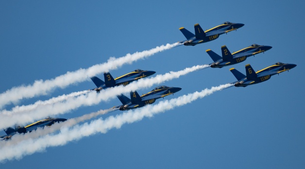
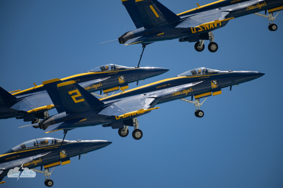
The U.S. Navy Blue Angels perform at the Air Dot Show in Cocoa Beach, Florida, April 12, 2026.
A sunny, windy day on Cocoa Beach provided a beautiful backdrop for the second day of the Air Dot Show on Sunday, April 12. That is, an air show, headlined by the U.S. Navy’s Blue Angels.
Huge crowds showed up on the barrier island, concentrated in the main show area in Cocoa Beach. I was at the house of some friends a bit south of that area, but we still had a very cool view from the beach. I shot photos with my Nikon Z8 and a 200-500 zoom lens – an older lens that requires an adapter to work with the Z-mount. It’s also heavy as heck, so my arms got a workout shooting thousands of photos.
Among the other aircraft featured: the B-52 Stratofortress, the F-16, and a plane and helicopters demonstrating refueling in the air from the 920th Rescue Wing. These are some of my favorite images from the day.
Click on any photo to start a slide show of larger images.
 I’ve just come back from a dream bucket-list trip to Iceland. Of course, the problem with any “bucket list” item is that you’re supposed to check it off. It’s done. It’s over. But I would love to go back to the dreamy skies and dramatic landscapes, which my husband and I experienced in all of their winter beauty, from snow-frosted black lava rocks to sparkling ice crystals to frozen waterfalls.
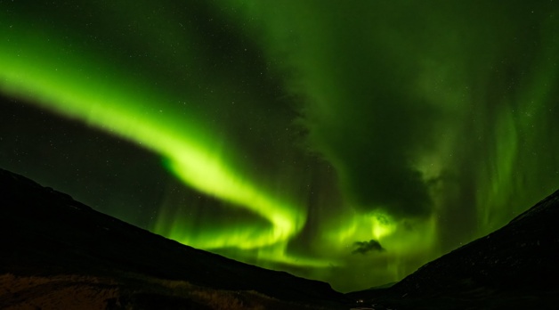
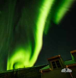
My No. 1 sub-item for this bucket-list trip was seeing the Northern Lights. I’ve seen them before from the U.S., during the May 10 and May 11, 2024, solar storm displays when Alethea and I took a detour from storm chasing to find them. While the pictures then showed a lot more colors than what I captured in Iceland, to the naked eye, they weren’t as vivid in terms of actual light. Up near the Arctic Circle — while the color was still somewhat faint — the features of the aurora were very much visible to the naked eye. The lights were almost like eerie self-illuminated clouds.
I saw aurora on multiple nights. We happened to be in Reykjavik when the big geomagnetic storm occurred, just before our tour began. Good news and bad news: We were in Iceland for the big event, but the aurora were competing with the city lights. However, they were spectacular anyway, and I’ll do a separate post about those two nights.
What’s amazing to me is that even if the parameters aren’t particularly promising, this far north, a big show can happen anyway. And that’s what we got on November 15 (into the wee hours of November 16) at Wilderness Center, a remote hotel set on an old farm in east-central Iceland. Framed by a river valley, the display was vivid and came in (at least) three waves. I only gave up because I was freezing and I wanted to go home with all my fingers. (Not really a joke – I think I was a bit frost-nipped.)
Here are some photos from the night, and check out the video as well. It moves from GoPro time-lapses of the early show and then time-lapses from stills shot with my Nikon Z8. I used the intervalometer setting for some of these and just manually shot the last sequence because I was in a hurry and didn’t want to waste time setting it up and miss part of the display. So occasionally there’s a wee bump, but the display was so amazing, I have no complaints.
You can click on any image to see a larger version and view the photos as slides. Stay tuned for more posts from this wonderful trip through a photographer’s paradise!
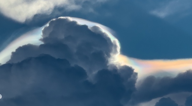
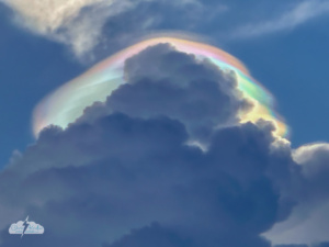
Iridescence in pileus cloud atop a growing thunderstorm in central Florida, Aug. 4, 2025. Photo by Chris Kridler, ChrisKridler.com
Pileus are short-lived wispy caps that form atop growing storm clouds, above strong updrafts. And I knew from previous experience that with the sun going down behind the building clouds, it was possible those pileus would display some iridescence. Or in the vernacular, they’d look like “rainbow clouds.”
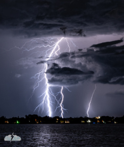
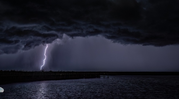
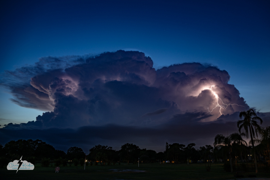
Cloud-to-ground (or cloud-to-ocean) lightning off Florida’s east coast.
The storms merged and pushed out a shelf cloud as it was getting dark, so I ran out and got a few photos as this layered, gloomy beast moved across the Space Coast. The heavy rain and lightning followed.
I went out one more time after the storms had mostly passed and shot photos looking east over the Indian River Lagoon. I was surprised at how much cloud-to-ground lightning still sparked as the storms moved over the ocean. There were a few lightning crawlers, too; I missed a couple of good ones, but I included one of the lesser ones here. I cropped all of these lightning photos to show off the intricate and amazing detail in the bolts.
Click on any image to see a larger version.
It’s been a weird summer here on Florida’s Space Coast. We’ve had weeks with no rain at all during the height of the supposed storm season, though this past week, we finally had some relief in the form of two gully-washer days in a row.
Tonight a couple of isolated storms popped up to our west, moving my way, and I realized I might have my first chance this summer for a local lightning chase. So I headed out to a favorite spot in Rockledge to capture the storms at sunset. For a little while, the storm popped with lightning almost continuously. Then it sent out what looked like an outflow boundary and clouds got in the way of my view.
Lightning storm as seen from Rockledge, Florida, on Aug. 3, 2025.
I moved west through Cocoa to a spot on the St. Johns River, hoping to get some cloud-to-ground lightning. As the storm weakened, there were a few bolts that I was pretty sure I missed. But I was luckier than I thought, and I was able to salvage a few so-so shots in editing. One was a blown-out bolt that was pretty spectacular, especially cropped as a vertical.
Here are a few shots from tonight. You can click on each thumbnail to see a larger version.
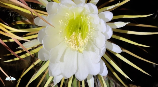
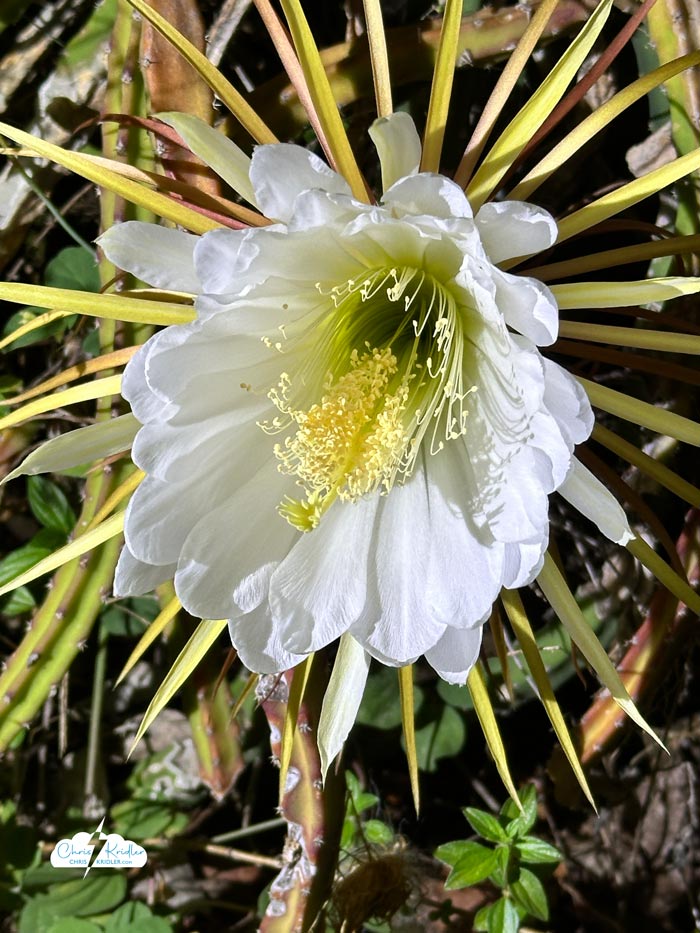
These showy night-blooming cereus flowers pop up on a cactus vine.
I missed the “big night” – there’s always one night when many, many of the blooms explode – because I returned from chasing storms the day after. But the blooms do appear for a while, popping up here and there. Until they don’t.
I’ve made several of these videos that you can see on my YouTube channel (please subscribe!), including a mini documentary that will tell you a little more about the blooms. This year’s video focuses on the mesmerizing beauty of one of these flowers as it opens. Check it out.
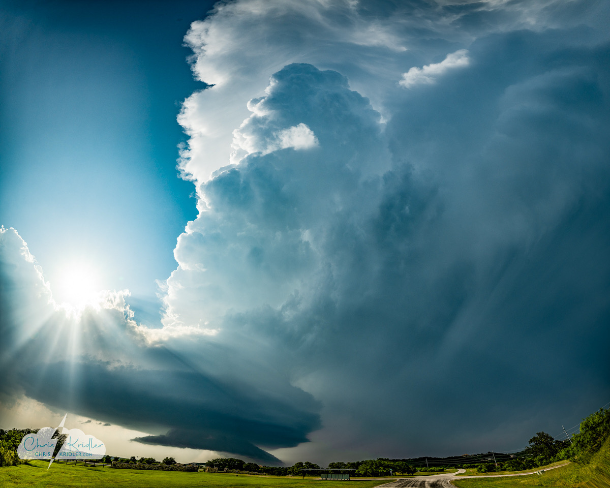
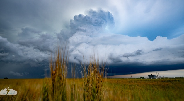
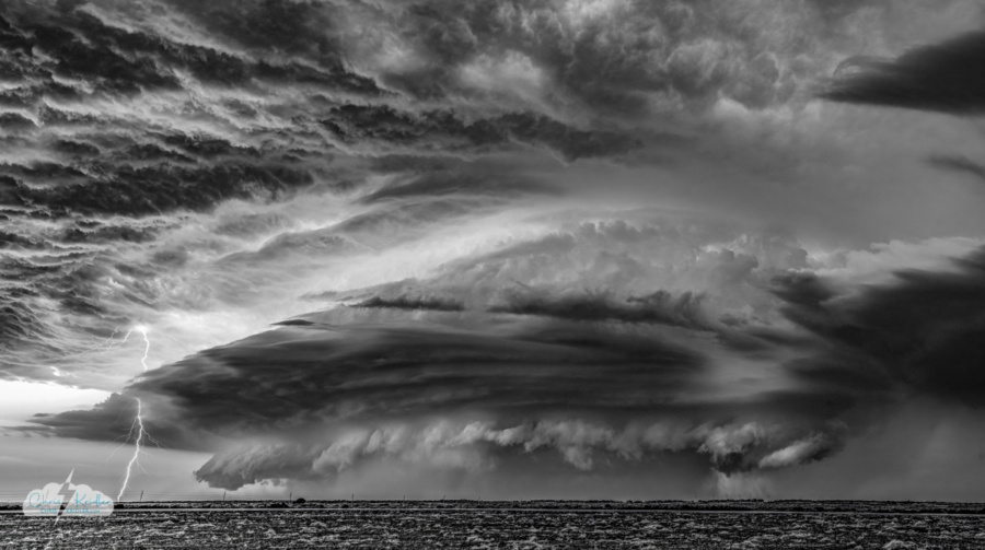
A supercell near Graford, Texas, on May 22, 2025.
We’re back from Tornado Alley! This trip with my storm-chasing partner Alethea Kontis went all too quickly, even though it was two and a half weeks. I sometimes wish I had the freedom to chase for a couple of months at a time, as some chasers do, but I still have a day job (editing books) and a fun job (writing books) and a husband and dogs and a life at home. So I enjoy the trip, and then I look for lightning when I get back home to Florida.
We saw five or six tornadoes, but most of them were in the “murknadoes” category — far away or difficult to see. The best tornado photo I got was probably a shot of a skinny little thing in Missouri, where I’d never seen a tornado before. And why “or six”? The last one was so murky, it’s super hard to see in my video, even though I think it’s there. All of this is to illustrate why seeing tornadoes is not really the most important thing to me when I chase storms, though I’m still frustrated when I miss them. Especially because our chase crew missed a couple of really photogenic tornadic storms due to bad decisions or poor timing. That’s the way the weather works sometimes and the way chasing works as well. Regardless, we still found beautiful storms to photograph.
One of the best things about this season — my 29th — was getting together with good friends whom we’ve barely seen in the past few years. Chasing together was a huge amount of fun. We hit thirteen states and drove more than 9500 miles, so we packed in a lot of adventure.
Alethea and I did several video updates from the road. You can check them out in this YouTube playlist. I’ll be posting more pictures and videos as I go through everything. I certainly got a lot of photos, and I can’t wait to share them with you. Thanks again to everyone who gave so generously to our gas fund! Stay tuned for more reports as I process all the images.
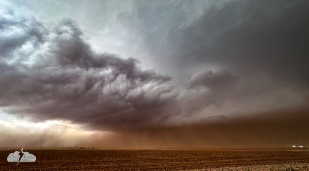
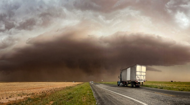
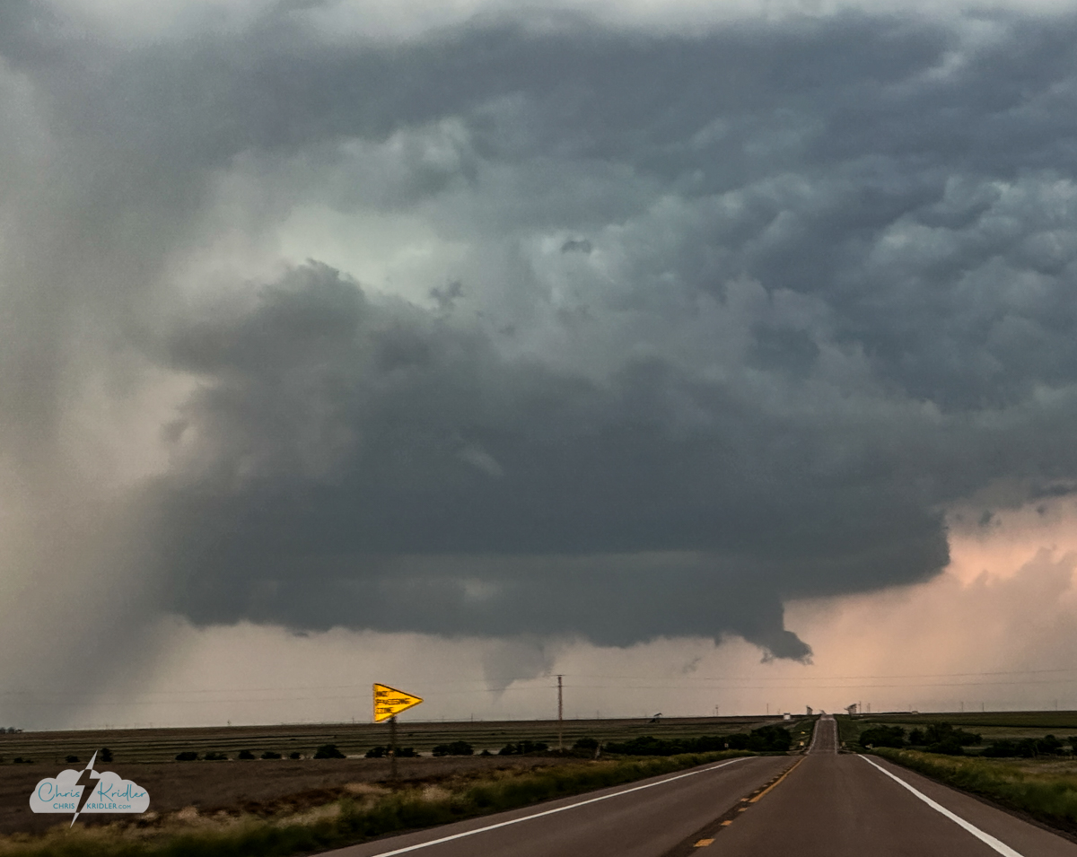
The last chase of the trip is always bittersweet. And on May 29, 2025, it was also exciting, confounding, and incredibly dusty.
Alethea Kontis and I targeted an area south of Levelland, which is west of Lubbock, Texas. The first storms almost immediately looked like they would form a line, which often means less power and less chance of tornadoes.
Landspout tornado spotted south of Brownfield about 5:19 p.m. CDT. It’s way back there in the dust.
Yet several short-lived tornadoes were reported with this dust monster – landspouts and otherwise – and with cameras we managed to see at least one of them. I say “at least” because in reviewing the footage later, it appears there are a couple more in my shots, but when you have to pore over your photos with a magnifying glass to be sure, the catch isn’t as satisfying.
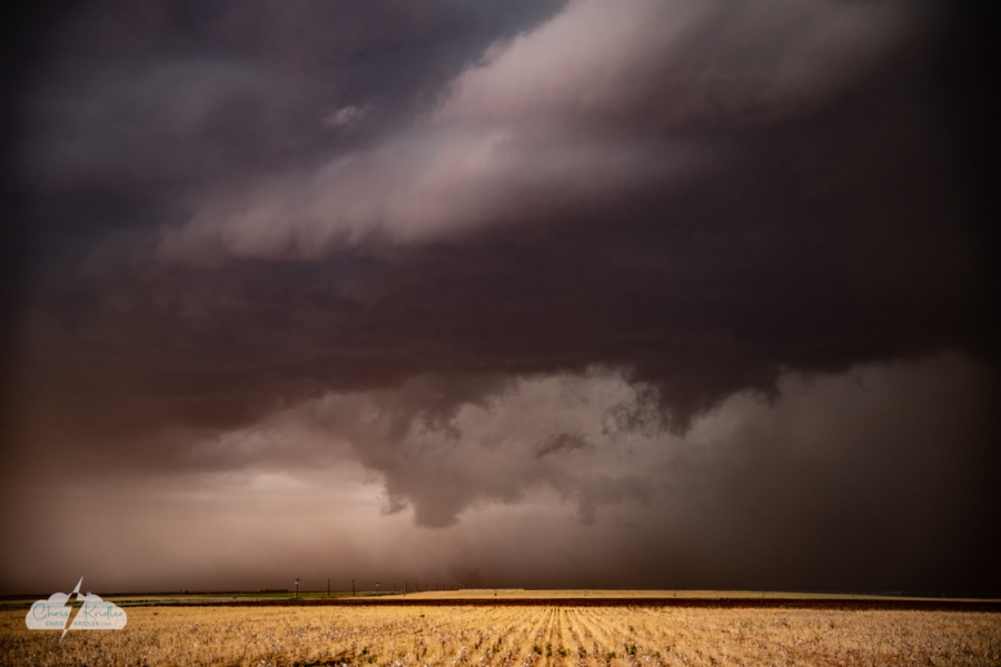
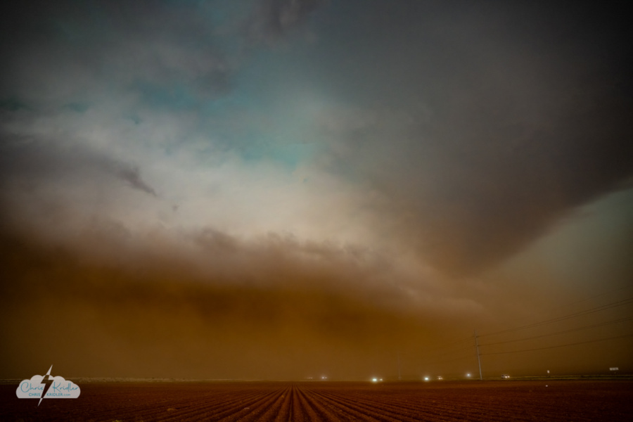
We mostly stayed ahead of the dust, though we couldn’t help sampling some of it as screaming inflow winds carried the red earth of west Texas into the maw of the beast. This storm also was warned for baseball-size hail, so I was loath to drive into it.
Dust – and hail. Note the green.
At times it felt like we’d entered the Upside Down, given the eerie haze, the mysterious heart of the storm, and the strange colors in the sky.
We played tag with the clouds of dust and plenty of storm chasers all the way to I-20, where we headed east, staying ahead of the worst parts of the line of storms until it overtook us.
Click on any photo to see a larger version and start a slide show.
Video grab of the short-lived tornado near Manter, Kansas.
And then, with storms everywhere, it was time to reroute and try to catch convection in the Texas Panhandle. South we went through the Oklahoma Panhandle and then into Texas. We weren’t on the right side of a great shelf cloud some chasers saw, but we got on a rotating storm with a gorgeous updraft near Darrouzette.
Lightning sparked in the storm near Darrouzette, Texas.
We photographed this storm until until another munched up behind us, and then we abandoned them and headed north, stopping at the Oklahoma border to check out some more great lightning. It was a fun day pursuing a smorgasbord of storms.
Click on any photo to see a larger image and start a slide show.
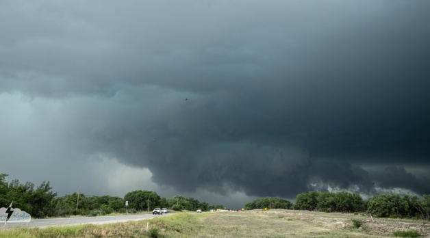
May 26, 2025, had Alethea Kontis and I chasing in west Texas, targeting an area south of San Angelo. Only issue was that a rotating storm was ongoing by the time we got there. We buzzed through the precip on the north side and dropped south, getting ahead of it at Menard.
Rotating wall cloud on the south side of Menard, Texas (GIF).
On the south side of town, we stopped to watch a rapidly rotating wall cloud. But as the storm encroached on our position, we took into account the hordes of storm chasers and the hail core (a 5.87-inch hailstone was reported) and decided to back off for safety.
South we went again, but between the hills, the trees and the increasingly messy storm, we didn’t see much more structure. The sky was still beautiful, though, as we reached I-10 and gave up the chase for the day.
Click on any photo to see a larger image and start a slide show.
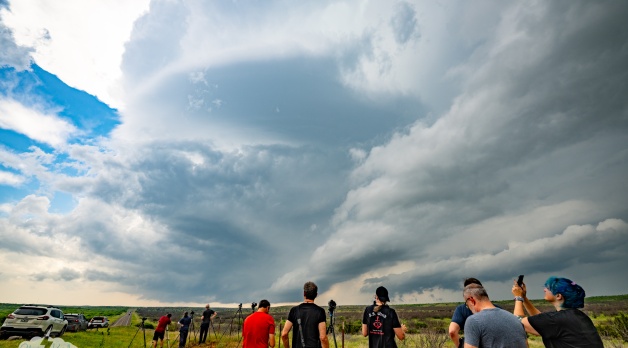
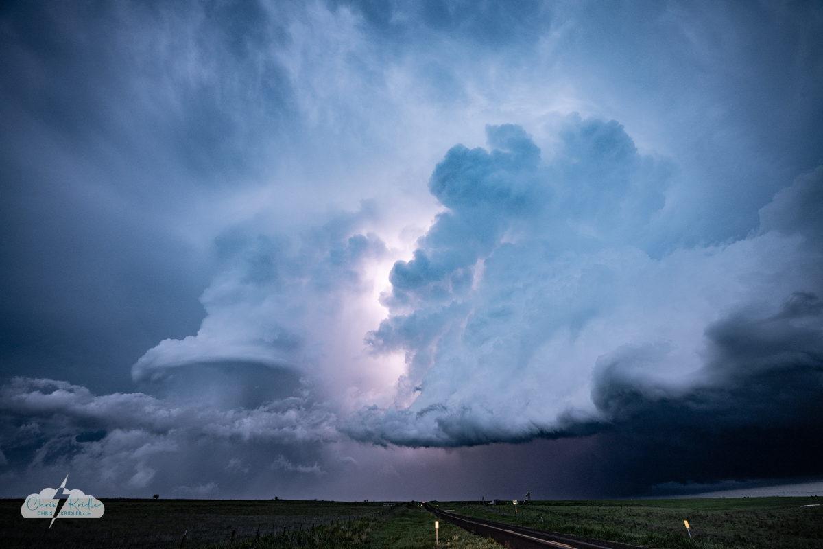
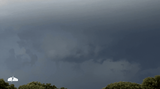
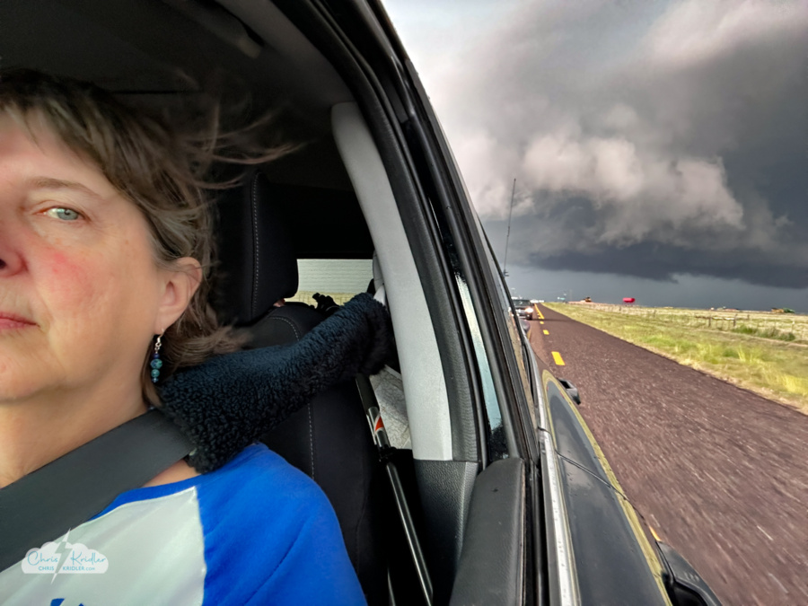
We continued south, expecting storms to go up early and line out early. But we were in for a treat – not one but two spinning supercells and an incredible lightning show.
We headed south and west out of Childress. Soon we were east of Matador along with a bunch of other chasers, watching a developing supercell to our west. Structure and radar indicated it had rotation, and it cranked up into monster mode. Hailstones up to 6 inches in diameter were reported with this storm!
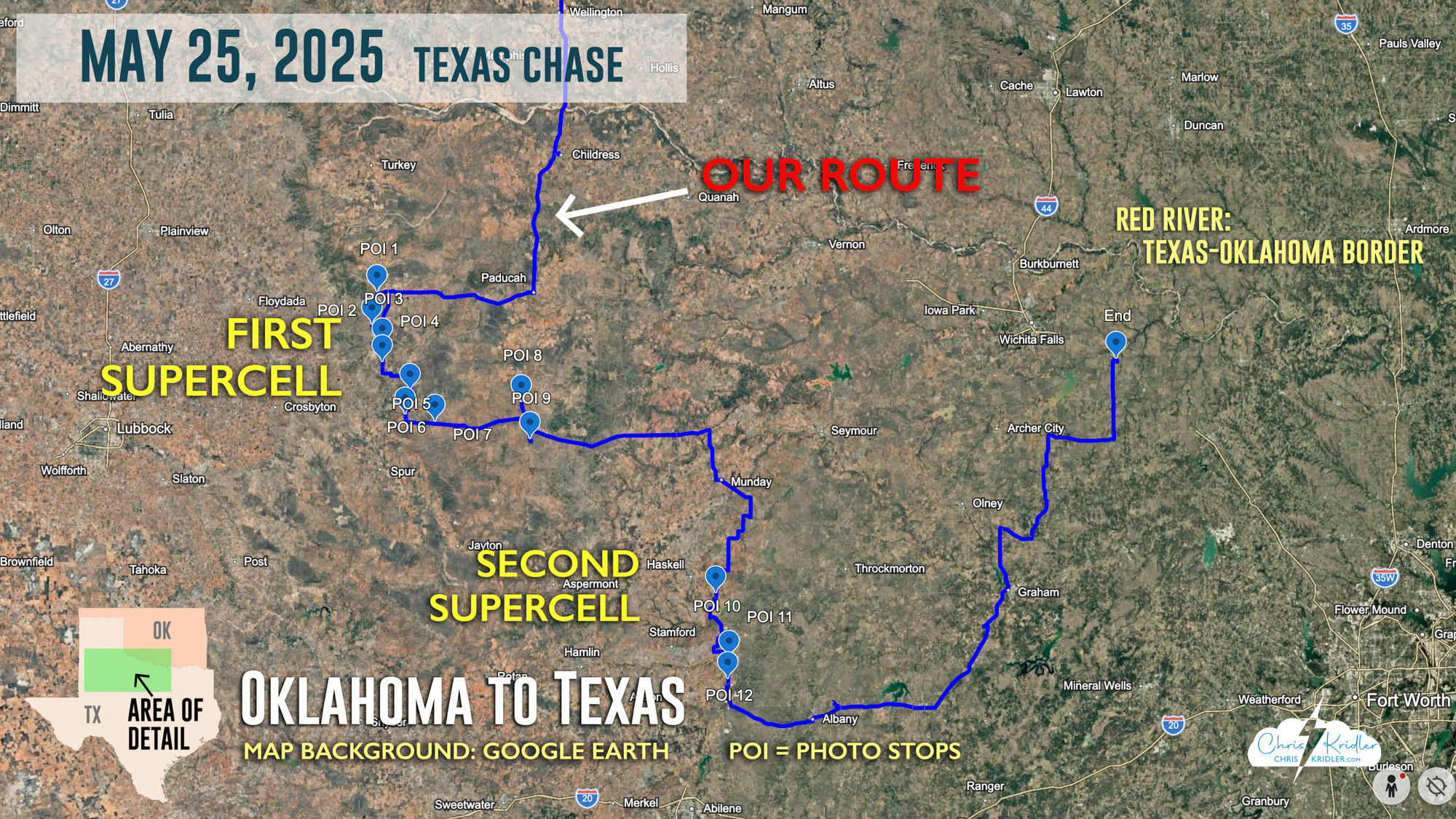
A map shows our route May 25. Click on it to see a larger version. Each “POI” or point of interest marks a photo stop.
We all got separated during the chase, which often happens, especially since Alethea and I tend to get farther out in front to capture the structure (and avoid the hordes and hail). We got some nice structure shots ahead of the storm, along with a few cows in the foreground. And I spotted what looked like a possible tornado near Afton, though we were quite distant from it – it was reported by another chaser. Yet even our friends who were closer weren’t sure of what they saw.
Fleeing the hail in the conga line of chasers!
And in spite of our best intentions, we ended up in a slow-moving traffic jam anyway as the hail core munched toward us. We successfully evaded it after a few tense minutes and moved farther south to chase another storm near Stamford. This photogenic supercell prompted more tornado reports. There was certainly visible rotation from our position and, even more terrifying, some of the most intense lightning I’ve ever seen.
A dramatic black-and-white edit of the lightning storm.
I stood outside the car for short time, shooting branchy cloud-to-ground bolts with no lightning trigger, using exposures of just under a second to maximize my chances. I caught several bolts before the rapid-fire barrage scared me enough to return to the car.
We stayed with the storm (or storms) for a while. Later, our party said goodbye to the northern chasers under lightning crawlers on an isolated road. What a way to end a spectacular day!
Click on any photo to see a larger image and start a slide show.


.")


.")


 lightning.")


