Chris Kridler
Chris Kridler is a writer, photographer and storm chaser and author of the Storm Seekers Series of storm-chasing adventures.

Chris Kridler is a writer, photographer and storm chaser and author of the Storm Seekers Series of storm-chasing adventures.
Today was the second day in a row I got to enjoy a shelf cloud and strong storm (today’s was severe) as it swept through the Space Coast.
Even better, we got a lot of rain. My parched plants, after several rainless, extremely hot days, seemed to breathe a sigh of relief – except for the palm tree that shed multiple fronds in the strong winds that blasted us today. Maybe it enjoyed the haircut.
This is a “short”/reel video, hence the annoying vertical format, but it seemed like a good way to share the highlights of the storm on my Instagram (if you’d like to follow me) and YouTube channel (ditto, please).
Yesterday’s storm (on July 12) was ominous and dumped nearly two inches of rain at our house, according to my unscientific rain gauge. (I really need a scientific rain gauge so I can report more accurately.) Anyway, it was quite impressive as I stepped out of the grocery store.
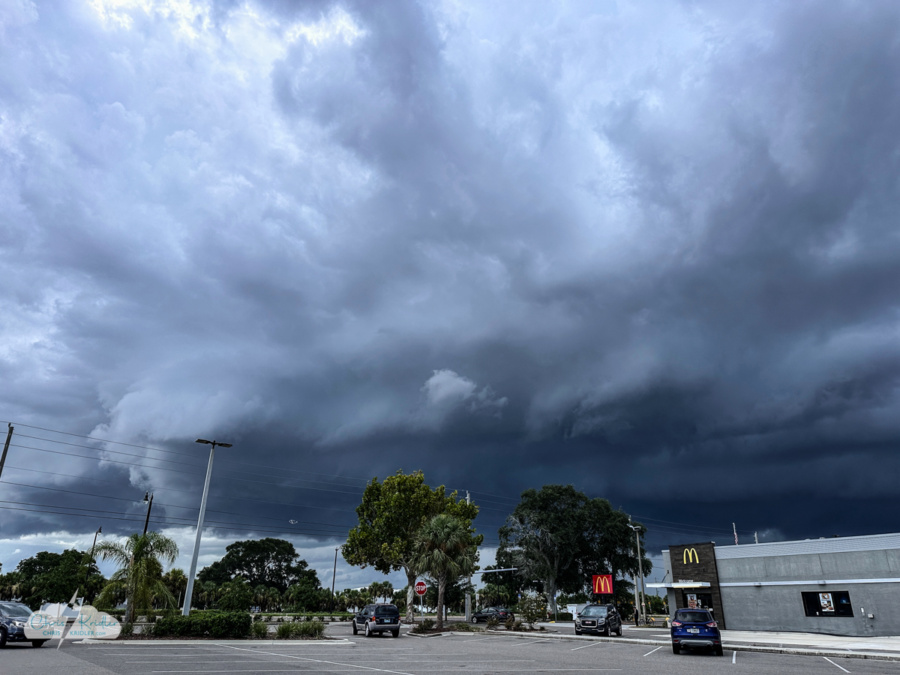
Ominous storm July 12 in Rockledge, Florida.
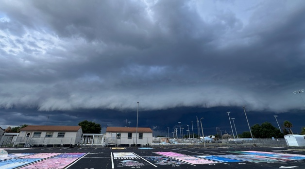
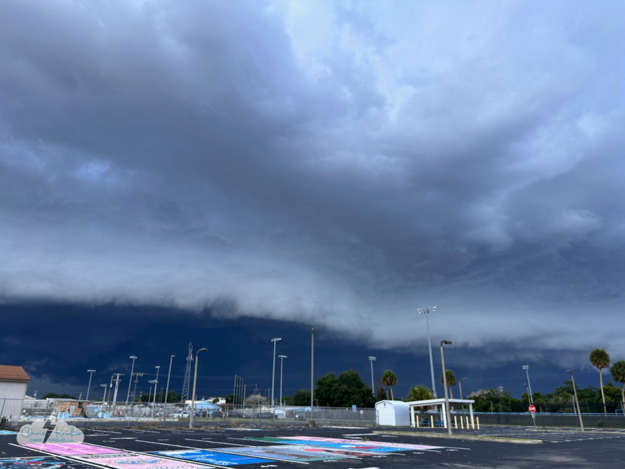
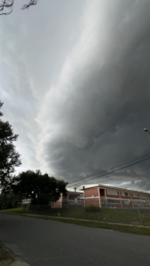
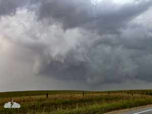
Today’s storm — on July 13 — earned a severe warning from the National Weather Service. It had beautiful structure as it moved across the Space Coast. Shelf clouds tend to mature and get prettier as they slide east to the beaches, but even on the mainland, where I caught it (or it caught me), it was gorgeous.
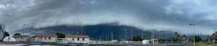
A shelf cloud on the leading edge of the severe storm July 13 in Rockledge, Florida.
The shelf moves in.
Overtaken by the storm!
And those aforementioned palm fronds, which you can see flying in the video, are all over our yard.
The dogs weren’t very happy with the lightning and thunder. But we’ll take whatever break we can get from this summer’s oppressive heat.
I haven’t done much in the way of storm chasing this summer, at least not yet. I’ve caught shelf clouds moving through our neighborhood. One even approached as I caught the bat flight out of our neighborhood bat box, which has become two boxes. The new one is supposed to lure the bats out of the old one, which is falling apart. After less than two weeks, it sure had attracted a lot of bats, as you can see in the video.
I caught more cloud iridescence on July 4 as well. As the sun slipped behind the towering storms to our west, the wispy caps of those storms lit up like a prism, making what some people call “cloud rainbows.” Diffraction causes water droplets or ice crystals to scatter light and make these colors.
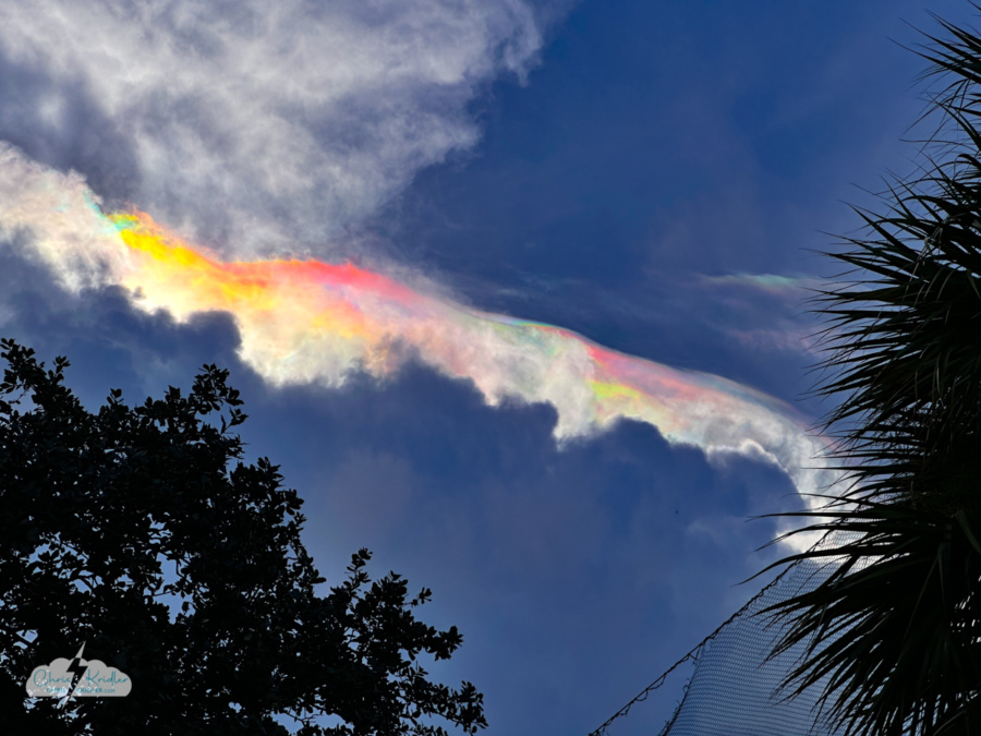
Cloud iridescence above central Florida storms on July 4.
While I’m often checking radar, and we’ve had a few gully-washers here on Florida’s Space Coast, unfortunately, there hasn’t been a lot of lightning at night. At least not within reasonable striking distance, so to speak.
The thing about Florida storms is they don’t last the way supercells in Tornado Alley do. They go up and down in about thirty minutes. So when I see nice lightning on my radar app and note it will take an hour to drive to a good vantage point for photography, I often give up before I ever set out. And of course, I don’t chase storms full-time. I’m busy working and don’t have the luxury of setting up for the daily sea breeze collision, alas.
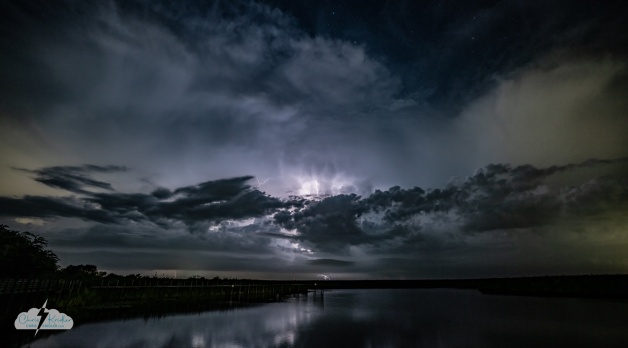
Lightning over the St. Johns River west of Cocoa, Florida, on July 8, 2026. Click to see a larger version.
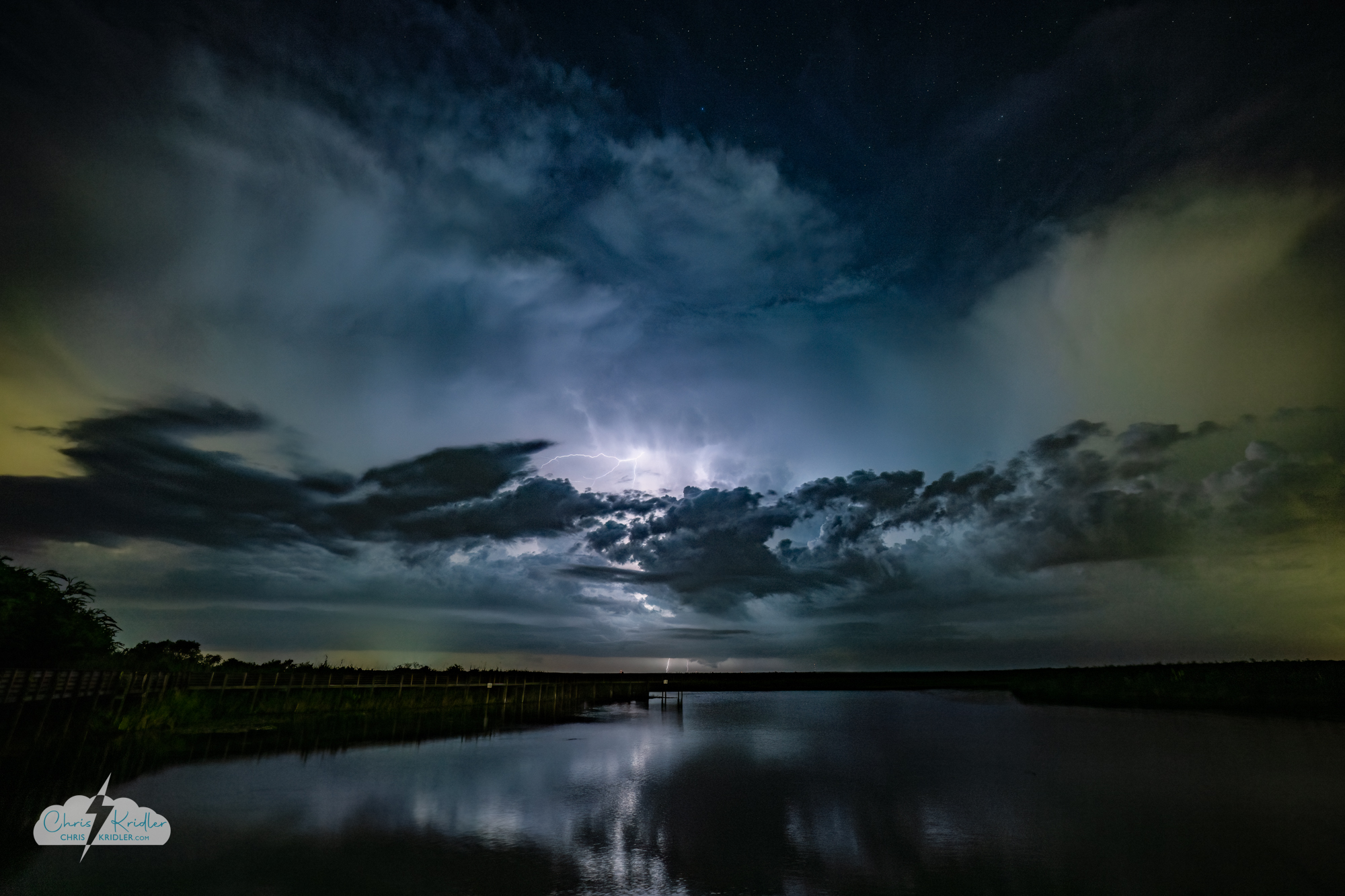
Still, after the lightning had been cooking for a while Wednesday night, I noticed the storms were persistent and thought I’d give it a shot. I stopped at a spot on the St. Johns River west of Cocoa, Florida, and got a few shots, including this one. The lightning seemed too far away, thought I love the moody wide shot with the stars overhead (some detail is lost at low resolution, but click on the photo to see a larger version).
I tried to get closer but realized most of the lightning was buried in rain. So I headed back east, stopping once more at the river to try to capture the looming outflow feature. It wasn’t quite as pretty as the earlier stuff, but I loved standing there in the quiet with the frogs chirping and the water occasionally sloshing. Alligators, maybe. The mosquitoes were less romantic, but it was still lovely to take a moment and enjoy the peace of nature.
Click on any of the following images to see a larger version and caption.
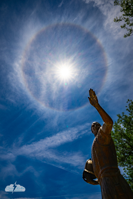
Coronado seems to point into the sun halo, adjacent to Liberal's Land of Oz.
On May 24, Alethea and I followed a sun halo to Liberal, Kansas. Sun halos seem to follow us around – or perhaps we’re just extra sensitive to them. I’m always looking for these rings of light caused by refraction in ice crystals in cirrus clouds. Halos can form around the sun or the moon and may be accompanied by other kinds of “rainbow” arcs. We saw one over Mount Rushmore in 2022, and I’ve seen them on the east and west coasts of Florida.
The Land of Oz in Liberal offered fun foregrounds for this sun halo. I shot a time-lapse as the fluff from the cottonwood trees floated through the air against the blue sky, catching the light like fairy dust. And then we moved on to Garden City, Kansas, and photographed clouds over a peaceful wheat field before capturing a stunning sunset near Satanta as the birds sang.
I made a video of all of this set to some very chill music. It’s the kind of thing I’ll watch when I can’t take the stress of everyday life, which, these days, is most of the time. A video doesn’t hold the same transporting power of actually storm chasing and being immersed in nature, but it helps.
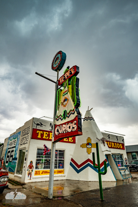
Storms on May 25 behind TeePee (or TePee) Curios in Tucumcari, New Mexico, a Route 66 landmark.
We’ve enjoyed visiting Tee Pee (Or TePee) Curios in Tucumcari in the past. It’s a great Route 66 landmark with lots of cool, kitschy souvenirs. So we headed that way as the clouds built.
The shop folk were kind enough to turn on the neon for a few minutes so I could get pictures as the sky darkened with clouds. As we emerged from the shop, the storms were roiling and spitting out lightning, and we got doused with rain. Still, there wasn’t a ton of structure, so we headed east, since we had reservations in Odessa that night.
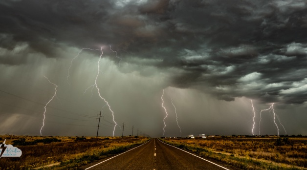
The lightning was so intense, we couldn’t resist stopping to check it out, coming back west a bit on Route 66 at San Jon. The Mother Road parallels I-40 there. We had almost no traffic to contend with, and the lightning was fantastic! We spent some time photographing the sparky show and caught a ton of bolts.
I wasn’t using a lightning trigger, just shooting almost continuously with my Nikon – and I filmed the storms with my phone, too. We even caught a couple of CGs with the Route 66 sign, to my delight. I stacked six exposures to show several of the bolts I shot from the middle of the road in a short period of time.
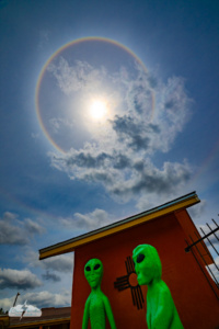
Alien life – sun halo with circumhorizontal arc in Roswell, New Mexico, May 26, 2026. Photo by Chris Kridler
We couldn’t resist a stop in Roswell, where another excellent sun halo was accompanied by a circumhorizontal arc. Great alien vibes!
We drove through a heavy storm near Ramon after stopping for a few photos, then followed the fading halo north, pausing a couple of times south of Santa Fe to take more pictures. I do love the Land of Enchantment. And it was fun to visit Santa Fe, however briefly.
I also think any day I can get a good photo is a good one, and we had three days of satisfying photography.
Click on any photo to see a larger image and start a slide show.
We had a productive day otherwise – filming a chase update and running errands, among them buying weed-trimmer line to try to clean out the drain tubes for my car’s sunroof. Why? The carpets in the CR-V were soaked! I’d ruled out the AC drain as the source of the leak and, through some googling and talking to my Honda guy at home, concluded a blocked sunroof drain was the culprit. There are four drains, and only the front two were accessible, so I could only hope I got out the clog. Unfortunately, the floors remained wet for the rest of the trip.
NB: I didn’t want a sunroof when I bought this car. But to get this “trim” of the Honda CR-V, I had to accept the sunroof that came with it. This is why I have a hail shield on my roof. All that said, I really hope I can get a nice car next time without a sunroof. Honda, are you listening?
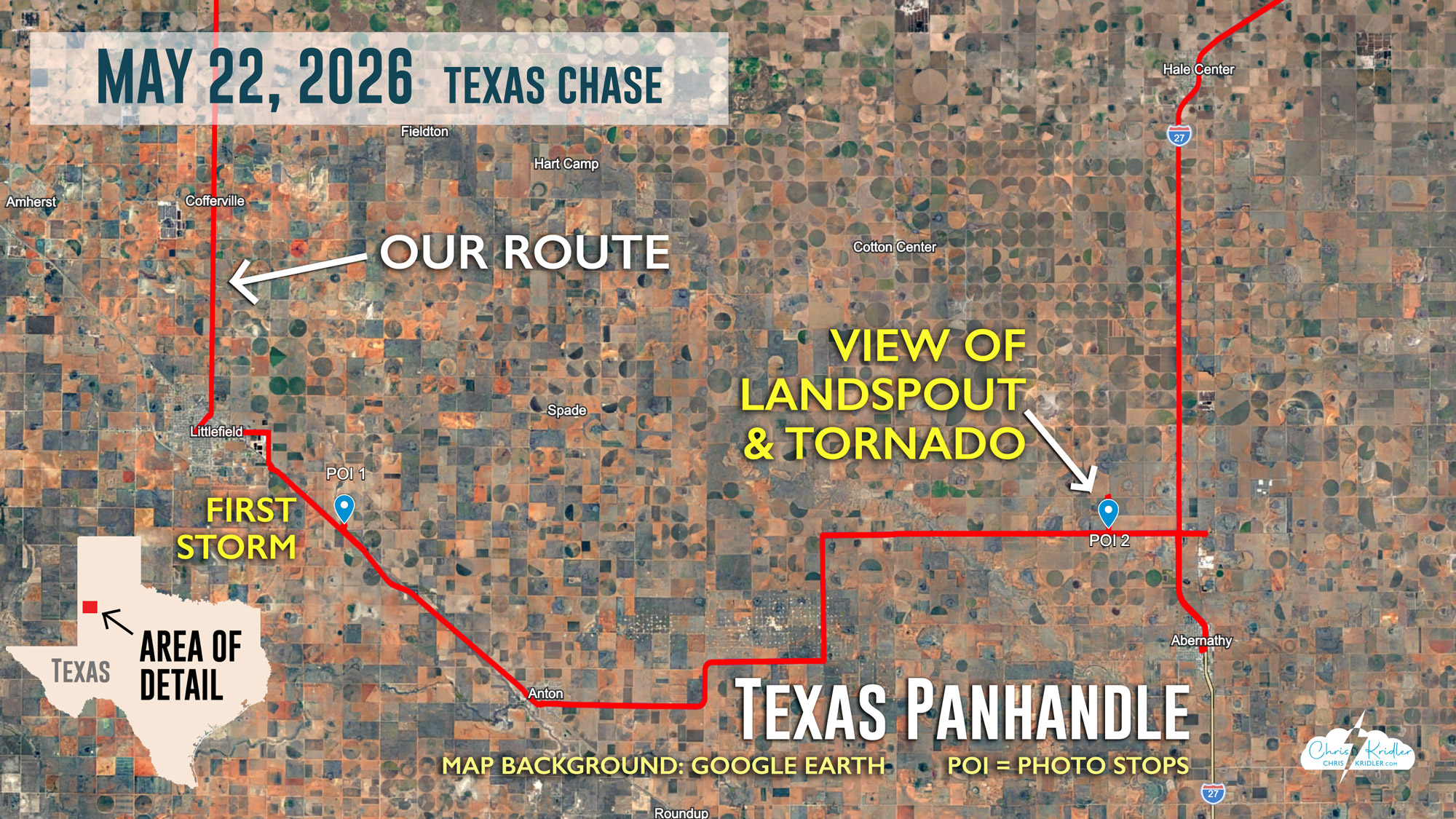
As the day progressed, we kept an eye on the chance for storms in the afternoon. We eventually met up with Bill Hark and headed north toward Dumas in the northwest Texas Panhandle.
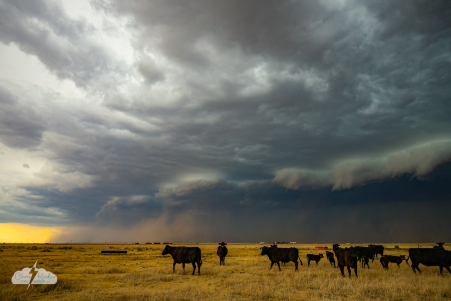
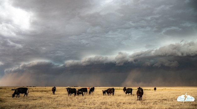
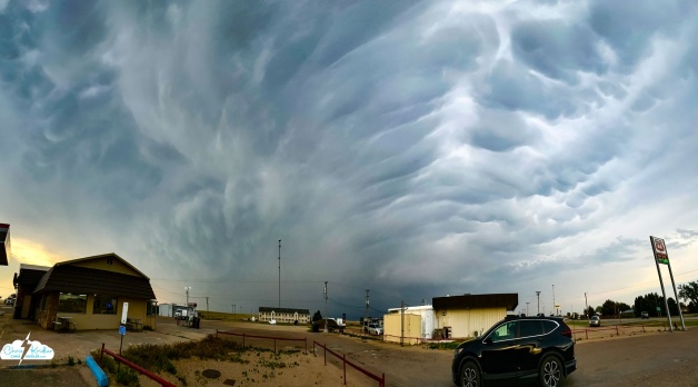
That dust and the structure west of Dumas signified the storms becoming outflow-dominant.
West of town, about 6:30 p.m. CDT, we intercepted a line of storms on the verge of a gust-out. As oblivious cows eyed us nervously, we watched the line of storms approach, kicking up dust as it went. And then the haboob chase was on!
It was seriously challenging to stay ahead of this beast. We paused briefly on the edge of town, then navigated out (briefly stymied by a closed railroad crossing) and south, and got far enough ahead to stop for photos. I was worried we wouldn’t be able to get anything, but the danger of stopping too soon was that we’d be overtaken by the dust.
We had just a few minutes to capture the incoming haboob. It was like something out of a movie – a jagged wall of brown dust roiling forward under the undulating jaws of the blue-green storm. It swept over the gold-flecked landscape like an angry wave.
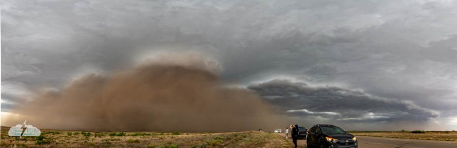
The haboob looks like a wave about to crash over us.

The storm moves over Slug Bug Ranch in Amarillo.
We navigated to Slug Bug Ranch along I-40, which is kind of like Cadillac Ranch, only a lot easier to get to. It’s situated in front of the Big Texan’s RV campground and includes, along with other upended vehicles stuck in the ground, graffiti-covered VW bugs that used to reside outside a derelict gas station in Conway. I’d photographed them there, too.
Other than the big, bright and visually disruptive streetlamps, this colorful installation made a cool foreground for photos and video of the incoming storm. Abandoned tech meets vibrant art meets the violent beauty of nature … I loved it.
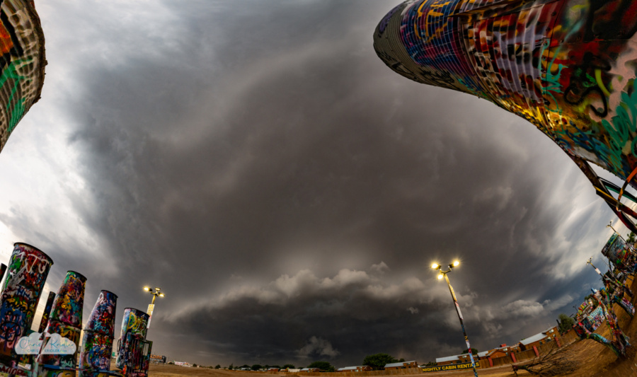
The warped perspective of this multi-image panorama captures the drama of the storm.
After the worst of the dust blew through, we moved to a gas station and enjoyed a barrage of small hail, then met Bill for tasty Asian food to end the day, not all that far from our hotel.
It’s a true gentleman’s chase (as Bill sometimes calls those rare convenient storm chases) when you end up back where you started – and where you’re staying.
Click on any photo to see a larger image and start a slide show.
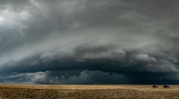
We watched a storm or storms — it was all pretty messy — and observed the beauty of a train moving over the Plains under a turbulent sky. But this storm wasn’t all we hoped.
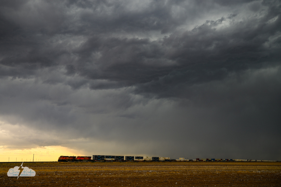
A classic sight: A train on the Plains under storms near Littlefield, Texas.
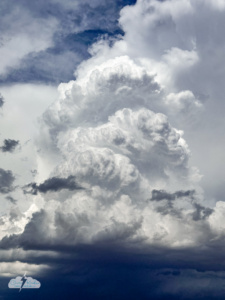
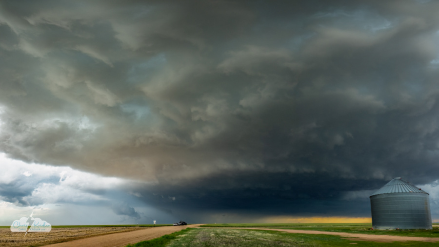
While this tower percolated northwest of Abernathy, Texas, the gears were turning in the atmosphere, poised to create a wild show.
This turned out to be a fateful and fortunate decision, as the next hour would reveal. We were surrounded by storms, each with its own agenda, and the atmosphere was about to lend a hand.
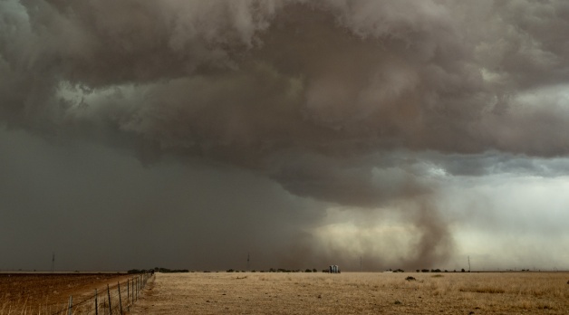
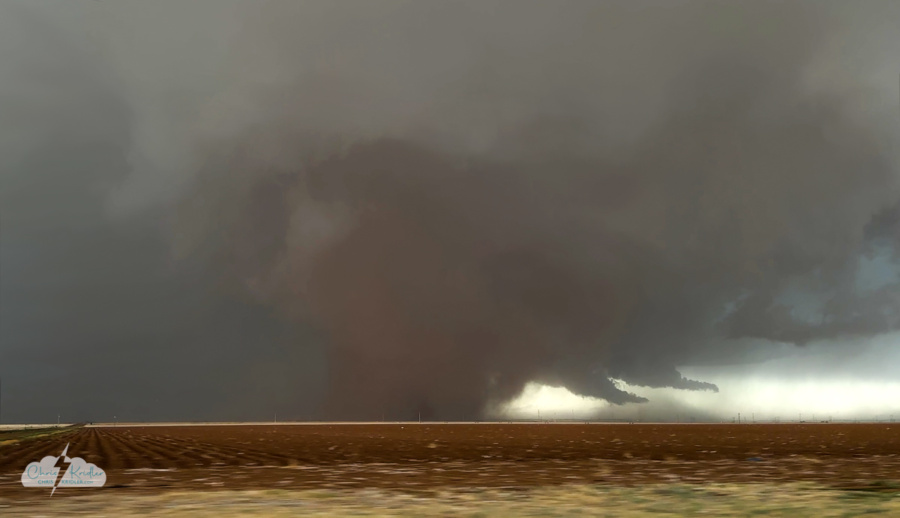
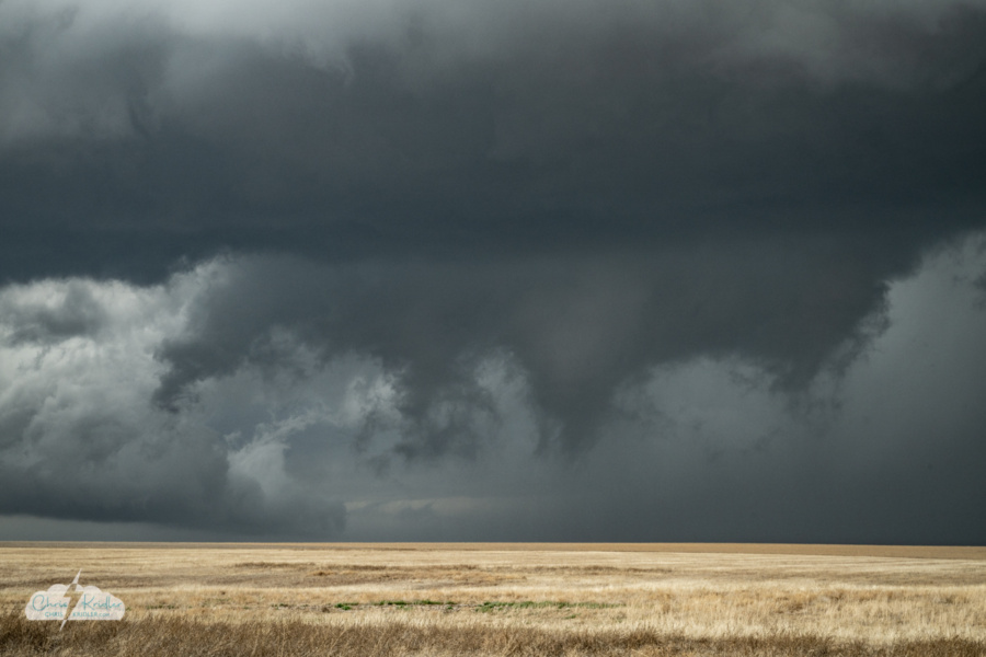
Not only did we have the gorgeous convection to the east; a storm to the west was spitting out dust whirls and then … “Dudes!” A landspout. A nice one. We watched it churn for several minutes.
Jack observed that the storm to the north also had intriguing structure.

To the west, the storm's dust became something more – a nice landspout tornado.
The storm to our north, which had already attracted our attention with its mesocyclonic features, now seemed a likely target. So we headed north about two miles on the same dirt road to observe as these boundaries swept through our position.
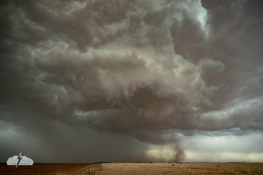
A tornado forms under the storm to our north.
The dusty tendrils under the base soon showed signs of rotation. We weren’t sure if we were seeing another landspout or maybe a gustnado, but the spinning dust grew. We were watching a baby tornado!
I tend to give more attention to shooting stills than video these days, but this instance is a good example of why I find filming storms so valuable. When I reviewed the footage, I realized we’d seen a multivortex tornado before I even knew what was happening. Even the dusty tornado that evolved, which from our angle wasn’t immediately obvious, was much more visible on video.
Rain began to pelt us and the wind kicked up, so we decided to reposition. This was another one of those situations where, if we’d been more east than south of the tornado, we would’ve had a better view. We were driving alongside a “dust wedge,” as I jokingly called it — a dusty tornado. It wasn’t particularly strong, but it was impressive!
A frame grab from my rough phone video of the tornado to our north as we headed east. A "dust wedge" – not that strong but wow! Consider this an impressionistic image, because I did some editing to smooth out parts of the blocky pixellated sky.
I was glad I angled my phone out the window as I drove. I was paying attention to the road, and phone video isn’t of the quality I’d like, but the video captures the essence of the beast. My screen shot from the video had blocky pixellation, so I did some editing in Photoshop to try to smooth out the sky. Consider this an impressionistic but accurate depiction of the tornado.
As I saw a smaller funnel emerging from the cloud of dust — what was left of the tornado — I called out on the radio, and we stopped to watch. But we were being pounded by rain, in poor visibility, as the tornado moved south-southwest and died before it got to us. The best part of the show was over, just like that. But what an unexpected thrill!
Here’s a map showing our route. Click on the image to see a larger version.
You can see the National Weather Service’s report on the day here.
We ended the day at the Big Texan in Amarillo, meeting up with chasers Jennifer Mitchell and Jason Foster, to enjoy the traditional post-tornado steak. And the roaming singers played a funny version of “Margaritaville” for us, since most of us came from Florida. If you live in Florida, you can’t escape Margaritaville, even when you’re in Texas.
Click on any image to see a larger version and start a slide show.
And check out our chase update from the next day, in which we talk about this chase.
On May 21, Alethea Kontis and I met up with chaser friends in Limon, Colorado, including Jason Persoff, Bill Hark and Jack Beven. This is Jason’s backyard, and he was optimistic that we’d get some “Colorado magic” while sharing his knowledge of the ways of the DCVZ. That’s the Denver Convergence Voriticity Zone that enhances the potential for severe weather in eastern Colorado.
Promising convection northwest of Limon yielded a distant landspout tornado. The storm became severe-warned, and we were off, heading north and then chasing this beast east. Or, at times, being chased.
Southeast of Last Chance we watched the beautiful storm. (Multi-image panorama)
We spent a lot of the day southeast of the aptly named Last Chance, on beautiful, remote farm roads. I think it was Jason who said he didn’t expect to see many chasers out here.
Friends, we saw hundreds of chasers. This is the new way, unfortunately. I know we’re chasers, too. I just wish there weren’t so many of us.
Crowds not only complicate tornado targeting and egress — they make it difficult to escape a hail core when it’s moving over a dirt road with no outlets.
We got into the fringe of this beast’s core and mostly suffered small but unnervingly loud hail as I cursed. A lot. (Edited out of the video.) I was not in the mood to have my car destroyed again, and fortunately, we were able to turn south and get out of the way. Other chasers were not so lucky and experienced extreme damage to windows and car bodies.
Interesting lowerings suggested rotation.
Meanwhile, the storm was rotating and became tornado-warned. We were with it the whole time, but with the hail and road challenges, we didn’t see a tornado. “Brief” tornadoes were reported. Eh, it wasn’t worth losing windows!
Maybe we didn’t have all the Colorado magic this day, but it was a fun and exciting chase and especially enjoyable with friends.
Click on any photo to see a larger image and start a slide show.
And here’s our update the next day when we talked about the chase.
Sometimes storm chasing is more about travel than storm chasing. Though May 18 — after the extremely frustrating traffic jams of our tornado chase May 17 – did offer chasing.
We couldn't keep up with this storm north of Minneapolis, Kansas, in the chaser traffic and missed the reported tornado.
I was ready to throw in the towel on storm chasing by the end of this day. I shot lots of video, but I’m not sure if any of it is worth posting.
We stopped for dinner at a yummy Asian place in Manhattan, Kansas, and let the storms roar over us. Small hail blasted my car just outside the window by our table. When the power went out in the restaurant, the kind staff still delivered our hot food, and we paid in cash on the way out after the worst of the storm had passed. We stopped and said hi to Bill Hark at a truck stop before hitting the road for our respective hotels.
The sky was eerily atmospheric, a kind of burnt orange layered with gray, as we traveled west, knowing our next chase was a couple of days away. We said farewell to Jason via ham radio, hoping we’d catch up with him again later, and continued to our hotel.
We allowed ourselves to be distracted multiple times as we meandered southwest the next day. I rescued a turtle outside of Kinsley, Kansas, aka “Midway USA” and the hometown of uber-talented singer-songwriter Freedy Johnston, where we stopped at a museum and got a few shots of the old train engine – the Atchison, Topeka and Santa Fe 3424.
Alethea had never seen Greensburg’s excellent Big Well Museum (only the gift shop!), so we made that our primary target for the day. The museum tells of the town’s history, including the EF5 tornado that devastated it in 2007. There are several artifacts, including the mangled tornado siren (with my old picture of the water tower and siren on the plaque). The top floor of the round part of the museum features 360 degrees of windows, with verbiage explaining locations old and new – those destroyed by the tornado and new green architecture built in its place.
The spiral staircase at the center of the space descends into the world’s largest hand-dug well, completed in 1888. It was a perfect venue for me to use the GoPro Max2 360 camera. Check out the video. It’s trippy! I love that Escher effect of seeing the top and bottom of the staircase at the same time. And I love the design of this museum, which echoes the tornado and the well and also hints at infinity and the possibilities of renewal.
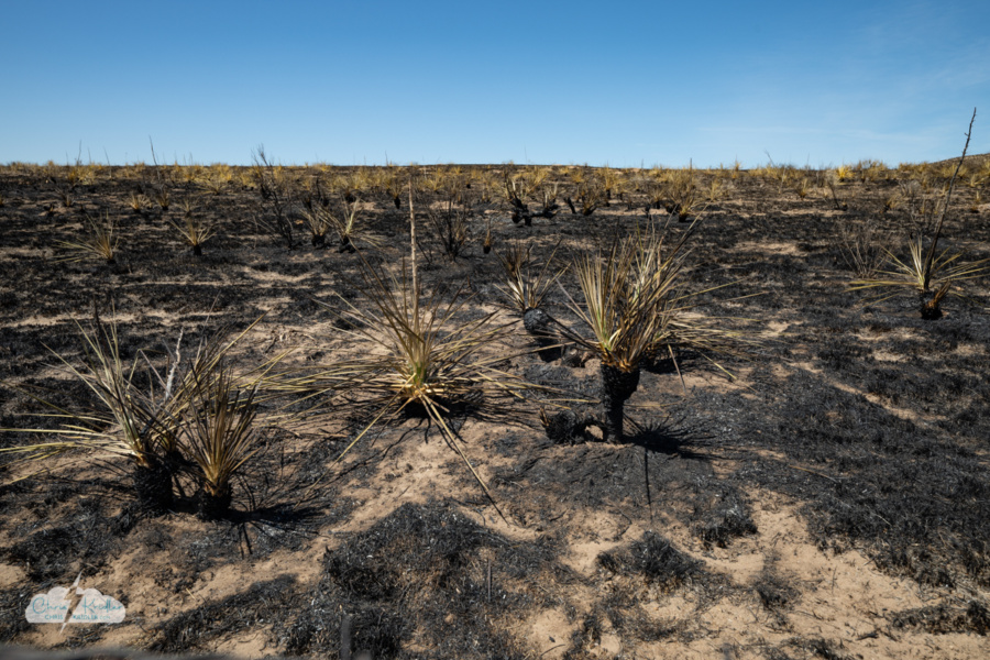
Scorched earth thanks to wildfires near Meade, Kansas.
From there, we drove through southwest Kansas, where great swaths of the prairie have been burned black by wildfires. We caught a few dust devils and eventually landed in Amarillo, because every chase trip requires a visit to the Big Texan Steak Ranch if at all possible.
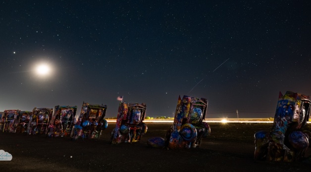
Since the weather was clear, it seemed like a decent night to try to shoot stars at Cadillac Ranch, the beloved art installation on the west side of Amarillo. But the moon was bright, and what was once in the middle of nowhere is becoming surrounded by truck stops and development. (There’s a stargazing scene here in my novel Tornado Pinball – I think it was darker then!)
We figured we’d be targeting Colorado on May 21, so on May 20, we headed north, stopping by the Cimarron Heritage Center in Boise City, Oklahoma. It really felt like Dust Bowl country this year, given how crispy the grass was. Locals hanging out at the gas station were talking about the fires and their dead lawns. These Panhandle towns feel so marginal, as in on the margins, incredible survivors in the face of a brutal environment.
We shot some time-lapse video of Cimmie, the apatosaurus sculpture, with the clouds and headed north into Colorado.
With a whimsical photo stop in Campo, known forever as the symbol of a remote chance paying off big-time thanks to a legendary tornado that happened near there, we aimed for Lamar. A stretched-out storm there had us pausing for a few photos before checking in to the hotel.
I feel bad that we don’t give Cow enough air time, so since we were staying at the Historic Cow Palace – a renovated old hotel that abuts a giant barn space filled with a dining area, other amusements and living tropical plants, with the humidity to go with them – Cow had his own adventure. We also ran into Bill there, so we enjoyed dinner in the unusual venue.
The beautiful theater in Lamar, Colorado.
I love storms, but I also love traveling through the Plains. Heck, I just love being on the road. There’s always something new to discover and experience.
Click on any image to see a larger photo and start a slide show.
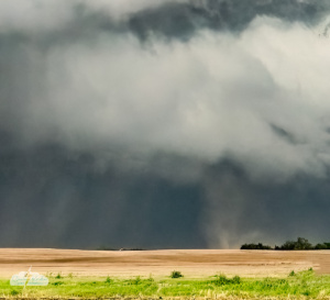
Tornado forms under supercell near Saint Libory, Nebraska, on May 17, 2026. This is a phone photo – more to come!
Hey! In case you haven’t noticed, Alethea Kontis and I are on the road in Tornado Alley. We’ve been chasing storms and seeing fascinating sights along the way. I already have a ton of content to post, but since we are driving CONSTANTLY, there’s not a lot of time to process it – though we are doing our best on the social sites (I recommend Instagram or Facebook). The 360-degree video I shot of a mammatus-filled sky May 17 is absolutely dreamy. I can’t wait to share it.
That said, check out the video feed to see our fun little updates, and please follow me on YouTube. Much more is to come!
Here’s the latest from our updates, and here’s the playlist on YouTube.
And thanks SO MUCH for supporting our gas fund. Alethea has all the links (and perks) here if you’d like to pitch in a couple of bucks.
Onward!
Alethea films an amazing mammatus-filled sky on May 17.
We waited in St. Paul for a while, watching the clouds develop, then went after a couple of storms popping up east of Ravenna and west of St. Libory. We monitored the developing storms as one became dominant, then repositioned south to get out of the rain and hail. This got us very close to the business end of the storm. We were in position to see the magic of tornadogenesis – but, as it turns out, out of position for what came next.
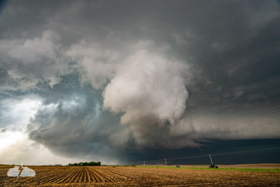
Tornadogenesis. The tornado begins right in front of us (see dirt in the distance). Note: Power lines removed in editing.
The storm was clearly rotating, and the structure looked chaotic. Its wall cloud was one of the weirder-looking ones I’ve seen, but it was whirling right in front of us. And then a tornado spun up under the spinning column of cloud. From our perspective, it was a rapidly rotating dust whirl moving east. Annoying power lines were in our way, but what a thrill to be so close.
And then, worse for us, a curtain of rain wrapped hard around the tornado with the rear-flank downdraft, smacking us with a wall of wind and water as we jumped into our cars and tried to get east.
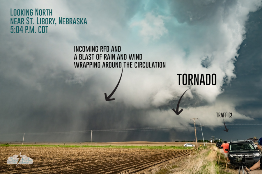
The annotated version showing the storm at 5:04 p.m. CDT.
A cropped image of the St. Libory tornado in progress. I've removed distracting power lines from the image.
Chasers who had positioned east and especially northeast of the meso watched the increasingly large, dark tornado (and got into some big hail). But we crept along in a futile slog through the precipitation that blocked our view, stuck in stop-and-go storm chaser traffic. Chase foiled.
Seeing tornadogenesis was fascinating and thrilling, but not getting the payoff of seeing the mature tornado was painful.
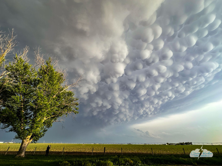
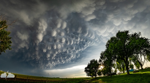
Feeling defeated, we paused after a fruitless pursuit on dirt roads, poised to give up. Still, I was intrigued by the radar and wanted to head south and target a storm in the developing line. And along the way, as we headed east on I-80, we were treated to a developing field of mammatus clouds overhead. We had to stop and check them out.

The mammatus clouds framed by the trees. Amazing!
These pouchy, smooth clouds are often seen in association with severe storms, under the anvil, and these were particularly stunning, filling the sky. We paused at a rest stop near York, Nebraska, to photograph and film them.
I used a GoPro Max2 360 camera to capture the mammatus on video. Check it out; this is the extended version, more than you’ll see in the video above. It makes me feel like I’m floating through these magical clouds!
I shot lots of photos of the storm and the mammatus, which redeemed our chase day. Click on any image to see a larger photo and start a slide show.
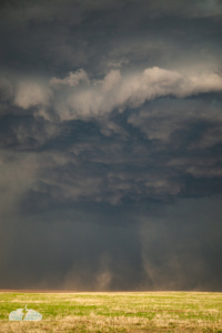
Dust is kicked up under a storm south of Seibert, Colorado.
We experienced the intense winds of the boundary and let it pass. What next? There was little chance of getting east of the most intense part of the line now.
We knew we wanted to go north for the next day’s chase. The question was, which way to go? We could’ve gone straight north and tangled, at least briefly, with the line. Instead, we moved south and east, back into Kansas.
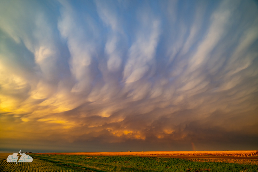
We caught strangely elongated mammatus over Sharon Springs, Kansas, then moved north, eyeing the back side of the storms as they were lit by the setting sun.
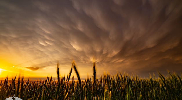
Beautiful mammatus with rainbow and Kansas wheat.
This was the best part of the day – stunning mammatus over western Kansas wheat fields at sunset. Gorgeous colors, golden light, and a soft stub of a rainbow all made this a magical conclusion to the chase before we headed up into Nebraska, anticipating the next day’s chase.
Click on any photo to see a larger image and start a slide show. I know there are a lot of sunset photos, but you should see how many pretty ones I left out!
Videos show our updates before and after today’s chase. We have a whole playlist of these from 2026, and more from 2025.

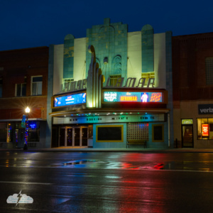
 appeared in a strong storm in the Melbourne area June 23.")


 is lit up orange.")

 Curios in Tucumcari, New Mexico, a Route 66 landmark.")


")


 to the east.")


.")
")


.")


 was of particular interest.")


. Note: Power lines removed in editing.")


")

 before rain obscured it. This is excerpted from a video frame as the rain began to hammer us.")


")


