Chris Kridler
Chris Kridler is a writer, photographer and storm chaser and author of the Storm Seekers Series of storm-chasing adventures.

Chris Kridler is a writer, photographer and storm chaser and author of the Storm Seekers Series of storm-chasing adventures.
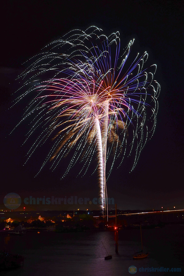
Fireworks light up the night in Cocoa, Florida, on July 4, 2013. Photo by Chris Kridler, ChrisKridler.com, SkyDiary.com
I was lucky to get invited to an Independence Day party on a top floor of a condo overlooking the Indian River Lagoon and Cocoa, Florida’s excellent fireworks display on Thursday. Shooting fireworks is a lot like shooting lightning – you need a tripod and a camera you can put in manual mode so you can hold the shutter open for several seconds. But at least you know approximately where the fireworks are going to be.
Want to see more? Here’s a slide show. Prints are available.
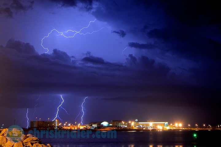
The best bolts were ending just as I got set up at Port Canaveral – of course. Photo by Chris Kridler, SkyDiary.com, ChrisKridler.com
While the lightning wasn’t so close that it sizzled, I did catch a few bolts in an atmospheric setting.
[Note: When this blog was first published, the tornado was rated EF5. It was later downgraded to EF3 based on damage alone, not wind speed, which was in the EF5 range.]
When people die, someone must be at fault, right?
Only sometimes, not any one person or group or thing is at fault. And usually, nature has the last word.
That was the case on Friday, May 31, when an EF5 tornado at El Reno, Oklahoma – the widest ever recorded at 2.6 miles – took the lives of three well-respected storm chasers and at least 17 others. Some died from flooding related to the storm, but the greatest media furor is centered on the tornado and those who were chasing it.
I was chasing it, but I am almost laughably cautious when it comes to tangling with a storm as explosive as this one. Most storm chasers are cautious to some degree and have a healthy respect for not just the storm, but others around them. There are exceptions, including a few of the “thrill chasers” some pundits are condemning, but most are at least providing ground truth about what a storm is doing, and some are relaying reports to the National Weather Service. Spotter Network, whose data was used in an animation to show spotters and chasers moving around the storm, is also used to relay real-time observations that help in warning the public.
Spotter Network shows chasers moving around the path of the El Reno tornado.
I like to know the nature of a storm before I get too close, and given the volatile atmospheric ingredients that came together that afternoon, I had healthy respect for this supercell.
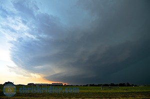
The El Reno supercell, early in its life. Photo by Chris Kridler, ChrisKridler.com, SkyDiary.com
When the first towers did break through just to our west, they exploded, developing almost immediately into severe-warned storms. We headed west, then quickly north and back east, dropping south of our original stop in El Reno to get into position as the southern storm took over. Even its appearance showed that it was rotating.
Our group became separated on Route 81 as we watched the storm to the west. At this time, perhaps dozens of storm chasers were in the area, and the Spotter Network animation shows they were widely distributed around the tornadic storm, though several clustered in the danger zone just east of the circulation. Tim Samaras, his son Paul and Carl Young, who were killed on the east side of 81 about the time the tornado was at its widest and most destructive, were apparently deploying scientific probes in the twister’s path.
Other chasers were just there for the shot, and some got perilously close. With a storm like this, anywhere close was perilous, given its sudden expansion and directional shift. While having access to radar data in our cars gives chasers a certain power when it comes to storms, it may also make us overconfident. So what if we can’t see everything happening in the murk? We have radar, right? It’s not like the old days, when we relied on our eyes to confirm how dangerous our position was in relationship to the storm.
Those who were smacked by debris and survived found an instant market for their video, which was snapped up by the networks. Brandon Sullivan’s team was hit by flying debris, including a huge, rolling hay bale, that provided endless fascination for TV talking heads the night of the tornado. So, I’m sure, did the “if you don’t go south, we’re gonna die!” screaming in the car.
Brandon Sullivan’s video is undeniably dramatic.
Were they too close? I guess that’s up to them to decide. Too close for me, yes. Whether they consider it a mistake or not, mistakes are understandable while chasing. As a chaser, I’ve made mistakes, too. Big hail has remodeled my car twice. While one can learn the basics of storm development and movement, it’s easy to miscalculate or run into forces beyond your control – bad roads, downed power lines. But you learn, and if you’re lucky, you get to chase another day.
Most chasers have a great reverence for the sky and a scientific interest in the weather, even if they aren’t scientists. As a photographer, I find storms challenging and enthralling. I don’t chase them to face death.
At any rate, storm-chaser survival has been the rule, not the exception. The El Reno storm is the first that has killed chasers in the act of chasing a storm, and the hobby has been around since the 1950s.
Chasers are divided about the events of Friday as much as anyone else. Some mutter quietly about the thrill-seeking elements, the my-car-is-more-badass-than-yours elements, the celebrity-seeking elements. Some spout, “Who are you to question my choice?” whenever anyone asks, “Were you too close?” I will question your choice if it puts others’ lives in danger or creates more problems for emergency managers, though that’s not usually the case.
What isn’t getting much attention in the media is the large number of “amateur chasers,” as they are unfortunately being called, who were out on Friday, as well as thousands of panicked citizens who took to the roads to escape. More on that in a moment.
In an ill-informed interview with Fox’s Neil Cavuto, meteorologist Janice Dean lamented that storm chasers (who are all thrill-seekers, in her opinion) and tornado tours were putting others’ lives in danger and clogging the roads. On pretty much every point, she was wrong.
Storm chasers drive ahead of a multivortex tornado in northern Oklahoma May 10, 2010. Photo by Chris Kridler, ChrisKridler.com, SkyDiary.com
April 14, 2012, in Kansas, was another one of those days, but I wasn’t there for that chase. However, there were reports of a lot of amateurs on the roads who had heard the dire forecast and figured they might as well get a look.
Increasingly, the problem is not the “professionals” (who, I suppose, are those of us with data in our cars, including radar, and a lot of experience). It’s those amateurs who see storm chasing glorified on TV and think that if that guy with the dash-cam can chase the storm, why can’t I?
Well, it may be that the guy with the dash cam also has enough gear to tell him the tornado is shifting southeast or northeast and is strengthening tremendously. That guy might have GPS software that clearly illustrates exit routes. That guy may have chased enough storms to know when to get out.
Clearly, one of the victims of the El Reno tornado was not that guy. Labeled an amateur, Richard Charles Henderson took cell-phone photos of the tornado and told a friend on the phone, “I’m having fun … you might even see me on TV!” according to an article in The Oklahoman. Sadly, he was killed shortly afterward.
He was not unique. I saw what looked like workers in their soiled shirts, perhaps just off their shift, pulled over and standing outside a pickup truck with their cell phones, shooting the tornado. The cable guy with blinking lights on his truck was doing the same thing. And a friend saw a man driving a pickup with his kids hanging out the window, taking cell-phone photos and cheerfully waving as they drove by.
I’d seen the same thing the day before in northeast Oklahoma. The lookie-loos were out in full force. Some were shooting with cell phones while they were driving, weaving all over the road. Others stopped in the middle of traffic. And when one of the three Dominators, Reed Timmer’s armored storm-chasing vehicles, ended up in a ditch, blocking half the eastbound lane on the only major road, they all stopped and got out of their cars and wandered over to look, with the storm’s rotation almost directly overhead. The resulting traffic jam could have been deadly if a tornado had dropped there.
The Dominator shares blame for that traffic jam, of course. Now the stars of a Kickstarter-funded web show called “Tornado Chasers,” the armored vehicles were featured on Discovery’s now-canceled “Storm Chasers.” So were filmmaker Sean Casey’s home-brewed tank, the Tornado Intercept Vehicle, and El Reno tornado victim Tim Samaras’ research vehicle. Tim Samaras was beloved in the storm-chasing community, a real scientist who was never considered an “extreme” chaser, though his scientific work inevitably involved risk.
As we’d hung out at an El Reno gas station earlier in the afternoon, monitoring the clouds and weather data, a young woman came up to us. “Do you all work for ‘Storm Chasers’?” she asked. No, I told her. We are storm chasers. And as much fun as it might be for us to see the media productions created by the tank drivers on television or IMAX or the web – I gave twenty bucks to the Kickstarter campaign so I could see Timmer’s show – the rest of us don’t necessarily want to be lumped in with them.
I consider such shows entertainment and mostly in good fun. I’ve been interviewed on a few “storm porn” shows myself (the chaser term for shows that exist mainly to revel in videotaped destruction), but I’m concerned that they make storm chasing look too safe. Yes, there’s always a disclaimer, and no, you can’t control what stupid people will do. But nonetheless, it’s a message problem, and storm chasers have to acknowledge it exists.
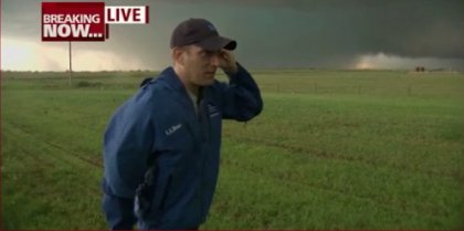
Mike Bettes was live before the Weather Channel vehicle’s encounter with the tornado.
The Weather Channel is now at the crux of this issue, as its own “Great Tornado Hunt” sport-utility vehicle was tossed and rolled by the El Reno tornado, with star Mike Bettes and crew aboard. They were lucky to get out alive. While TWC preaches safety, it also deployed much-admired meteorologist Jim Cantore in one of self-labeled “extreme meteorologist” Timmer’s Dominators this season, a decision that left many storm chasers scratching their heads. Again, what’s the message? Are you extreme, or are you safe? Are you hunting tornadoes or informing the public? Can you do both? In a Weather Channel interview after the May 31 storm, Cantore said storm chaser deaths were inevitable: “Everybody was way too close to this tornado.”
The “amateur storm chasers” weren’t the only ones clogging the roads. Though I stayed well back from the record-breaking tornado, my true terror began when I made a routine maneuver, planning to drop south and then west to catch the back end of the building storms. My intention was to avoid Oklahoma City entirely. Instead, with roads additionally limited by the Canadian River, I found myself in a southbound traffic jam, with the storm and new circulations bearing down on me and countless other cars. It was the first time while storm chasing that I ever felt I might die, and several other chasers expressed the same sentiment in social media, especially those still in the path of the main, eastern circulation that had produced the giant tornado.
The National Weather Service was telling people to stay off the roads well before the storms fired that day. But mid-storm, a meteorologist on KFOR-TV told viewers, “You’re going to have a tornado go through south Oklahoma City right now … it’s heading right for downtown … if you can drive south [from several areas of the city, which he lists] … you need to drive south now or get below ground.”
Telling huge swaths of a city to “drive south now” is the worst possible advice to give anyone, let alone people already shaken by the May 20 EF5 Moore tornado. It’s important to have a plan for shelter that doesn’t involve driving away, because a car is not a safe shelter. Ditches, often touted as a last-resort shelter, became death traps for some victims, too, as they flooded.
KFOR advises viewers to flee.
As Ian Livingston and Mark Ellinwood wrote in The Washington Post’s Capital Weather Gang blog about their decision not to chase in this area that day, “we agreed that odds were good it could end up too dangerous to try to chase the day’s storms anywhere near the Oklahoma City metro.”
But El Reno didn’t seem all that metro to me. We were far enough west of the city that we were surrounded by cows and wheat fields. The southbound road I chose was like one of the rural roads I grew up on in Pennsylvania, narrow, hilly and wooded. There was no way it should have been bumper-to-bumper with cars. Boy, was I wrong.
The cars crept south, with fender-benders and breakdowns along the way, disaster-movie-style, and I kept an eye on the radar. While the most vigorous circulation passed to my northeast, a second one looked as if it would pass directly overhead. It did, just as the cars slowly merged onto Route 4 south and I crossed the Canadian River. I had nightmares of being thrown off the bridge, just another statistic in a deadly tornado season. My special knowledge of storms did me no good, because I was mired in a mass panic.
Fortunately, the circulation didn’t strengthen enough to drop a tornado on my location, but southbound drivers noted the intensification of the winds and rain and accelerated, filling all lanes and shoulders southbound – even the northbound lanes. I understood, because any inch I got south before it hit, I figured, would be another inch closer to safety.
I don’t blame the people around me. I don’t blame the storm chasers. I don’t blame the amateurs for getting me stuck in the traffic jam, though I do blame KFOR, at least a little. Hundreds of people could have died.
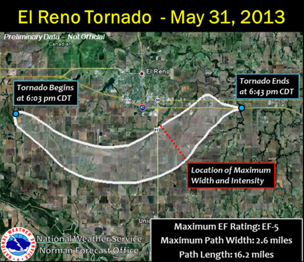
National Weather Service graphic shows the path of the May 31 El Reno EF5 tornado.
Ultimately, the tornado had the last word, expanding rapidly from about a mile across to a record 2.6 miles as it accelerated and jogged northeast. It’s incredible that more storm chasers weren’t killed, since some were so close to the circulation.
In the wake of the event, there’s been mourning, posturing, admonishments and a fluidly shifting narrative evident in storm chasers’ posts about this historic day. We’re all wrestling with not one problem but many. From storm chasing to media coverage to public awareness, the situation in Tornado Alley is complex. The public needs better education about the perils of storms and driving near them. The media must be better informed about safety and about storm chasers. Storm chasers should consider the consequences of driving into danger and also think about how they want to be seen by the public. Lawmakers want to look like they’re taking action, and to do so, they have to blame someone. If and when regulation is proposed, I hope it doesn’t target those of us who know what we’re doing and do it circumspectly.

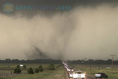
The El Reno supercell’s huge tornado was obscured by rain and dust to observers any distance away. Photo by Chris Kridler, ChrisKridler.com, SkyDiary.com
Friday was a terrible day, but I still want to see more storms. They are the only impartial and unstoppable forces in this drama, and they will still spin across the Plains, beautiful and dangerous, whether or not there are witnesses.
Chris Kridler is a writer, photographer and storm chaser and author of the novels “Funnel Vision,” “Tornado Pinball” and “Zap Bang.”
My video account of the El Reno, Oklahoma, chase on May 31, 2013.
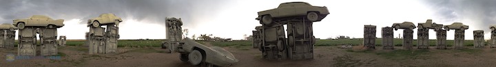
A panorama gives the full-circle view of Carhenge at Alliance, Nebraska, May 25.
We started the day in Norman, Oklahoma, and targeted just west of Oklahoma city at El Reno. There was a huge amount of potential for severe storms and strong tornadoes. By 5 p.m., three storm cells had fired and expanded rapidly just west of our I-40 exit at El Reno, so we popped west to check them out – then just as fast went back to where we’d been.
One explosive cell produced a wedge tornado that killed several people, including three storm chasers, and emphasized the hazards of chasing anywhere near a metro area. The tornado was rated EF5 (radar measured 296 mph winds) with a record width of 2.6 miles. (Later, it was downgraded to EF3 based on damage alone, despite wind measurements.)
The captions of my photos tell what it was like to be chasing that day. I thought I was safe – and then I wasn’t, as I got caught up in a terrifying traffic jam in the path of a mesocyclone.
Please also see my extensive blog post concerning the events of this day: Storm chasers, media, public all had role in drama of El Reno tornado
Note: This report has been transferred and updated from my old Sky Diary site.
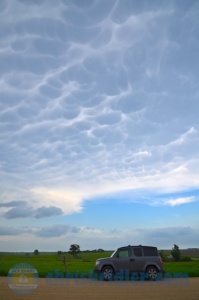
The mammatus were a sign of the storm’s vigor. Photo by Chris Kridler, ChrisKridler.com
This target seemed the best of the lot (and the most reachable from our morning position in western Kansas), and conditions seemed more and more favorable as the day went on and we approached the target area near Salina. Storms fired in various targets this day, but this was the whopper, producing a 40-minute wedge tornado that barely moved.
Of course, we didn’t know it would barely move, so some of us had a more distant view than others as we got into position to intercept it. I’m one of those. But since it was my first wedge tornado in 17 years of storm chasing, I still count it as a pretty productive day, especially since no towns were struck.
Note: This post has been updated with information and images from my old Sky Diary site.
Roll over a photo to see its caption, and click on any of the pictures to start a slide show of larger images.
We started our chase near Plainville, Kansas, choosing to ignore the messy rotating storm cluster to our north near the Nebraska border that eventually produced tornadoes. We split up during the chase, which was a fairly typical non-tornado chase – pretty storms but no major drama.
Still, it made for interesting video, especially the mesmerizing time-lapse of the retreating aforementioned rotating storms at sunset.
Roll over a photo to see its caption, and click on any of the pictures to start a slide show of larger images.
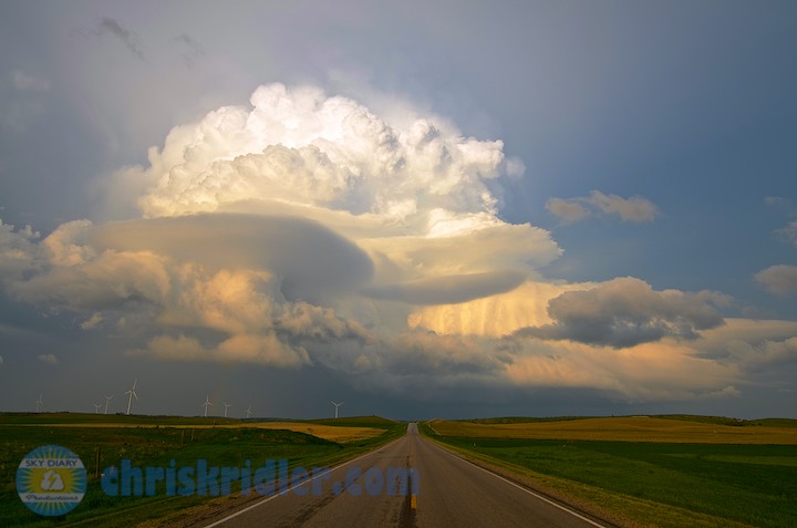
One of the most impressive storms of my 2013 Tornado Alley chase didn’t produce a tornado, though it was tornado-warned. That’s because it was spinning like a top. The May 26, 2013, supercell near Arcadia, Nebraska, was LP, or low-precipitation – not much rain, but amazing structure. It also had one of the best lightning shows I’ve ever seen.
I chased this day with Greg Stephens, Dayna Vettese and Brad Rousseau, Bill Hark, and Robert Balogh. We started the day in North Platte, Nebraska, dropped south to McCook and then headed back up to North Platte, hoping storms would fire along the dryline push. There was a high risk of a blue-sky bust, but just when we were about to give up, a couple of storms exploded.
This is the road I always want to be on! Inflow features made the storm even more interesting. Photo by Chris Kridler, ChrisKridler.com
Note: Post updated with images and details transferred from my old Sky Diary site.
Roll over a photo to see its caption, and click on any of the pictures to start a slide show of larger images.
There it goes, a cloudy galaxy. Photo by Chris Kridler, ChrisKridler.com
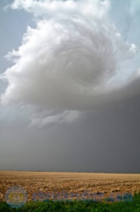
I chased today with Greg Stephens, Dayna Vettese and Brad Rousseau. We started the day in Liberal, Kansas, and targeted northeast Colorado and the dryline as a trigger for storms. It took a while for them to get going, but we saw some extraordinary motion and lightning.
This storm, which we chased from northeast Colorado into Nebraska, was filled with high-based rotation, shear funnels and lightning and eventually was severe- and tornado-warned. But the “cinnamon bun” swirl above our heads was its most beautiful and entrancing moment. The video includes time-lapses of it.
Roll over a photo to see its caption, and click on any of the pictures to start a slide show of larger images.
I chased storms on May 20 with Dave Lewison, Scott McPartland, Dayna Vettese and Brad Rousseau, Greg Stephens, and Mark Robinson and his Weather Network crewmate Jaclyn Whittal. We started the day in Norman, Oklahoma, and chose southern Oklahoma as our target, not realizing that a devastating tornado would strike so near to our starting point later in the day.
We saw a tornado, too, but there was no joy in storm chasing this day when we heard the news about Moore being struck.
The May 20 Duncan, Oklahoma, tornado was small, and the condensation funnel didn’t extend all the way to the ground, but we had confirmation that the circulation did indeed contact the ground. After we saw it, we saw the radar from the Moore, Oklahoma, tornado and knew we had missed a large and devastating tornado. A lot of the storm chasers (and there are so many these days) were in our target area and missed it, too.
Note: Post updated with images transferred from the old Sky Diary site.
Roll over a photo to see its caption, and click on any of the pictures to start a slide show of larger images.


