Chris Kridler
Chris Kridler is a writer, photographer and storm chaser and author of the Storm Seekers Series of storm-chasing adventures.

Chris Kridler is a writer, photographer and storm chaser and author of the Storm Seekers Series of storm-chasing adventures.
 I’ve just come back from a dream bucket-list trip to Iceland. Of course, the problem with any “bucket list” item is that you’re supposed to check it off. It’s done. It’s over. But I would love to go back to the dreamy skies and dramatic landscapes, which my husband and I experienced in all of their winter beauty, from snow-frosted black lava rocks to sparkling ice crystals to frozen waterfalls.
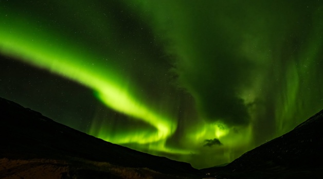
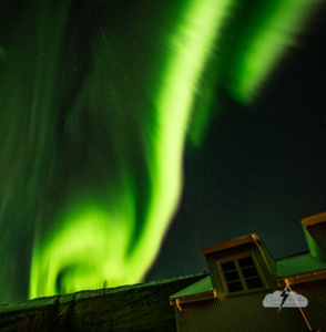
My No. 1 sub-item for this bucket-list trip was seeing the Northern Lights. I’ve seen them before from the U.S., during the May 10 and May 11, 2024, solar storm displays when Alethea and I took a detour from storm chasing to find them. While the pictures then showed a lot more colors than what I captured in Iceland, to the naked eye, they weren’t as vivid in terms of actual light. Up near the Arctic Circle — while the color was still somewhat faint — the features of the aurora were very much visible to the naked eye. The lights were almost like eerie self-illuminated clouds.
I saw aurora on multiple nights. We happened to be in Reykjavik when the big geomagnetic storm occurred, just before our tour began. Good news and bad news: We were in Iceland for the big event, but the aurora were competing with the city lights. However, they were spectacular anyway, and I’ll do a separate post about those two nights.
What’s amazing to me is that even if the parameters aren’t particularly promising, this far north, a big show can happen anyway. And that’s what we got on November 15 (into the wee hours of November 16) at Wilderness Center, a remote hotel set on an old farm in east-central Iceland. Framed by a river valley, the display was vivid and came in (at least) three waves. I only gave up because I was freezing and I wanted to go home with all my fingers. (Not really a joke – I think I was a bit frost-nipped.)
Here are some photos from the night, and check out the video as well. It moves from GoPro time-lapses of the early show and then time-lapses from stills shot with my Nikon Z8. I used the intervalometer setting for some of these and just manually shot the last sequence because I was in a hurry and didn’t want to waste time setting it up and miss part of the display. So occasionally there’s a wee bump, but the display was so amazing, I have no complaints.
You can click on any image to see a larger version and view the photos as slides. Stay tuned for more posts from this wonderful trip through a photographer’s paradise!
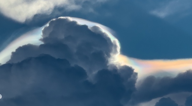
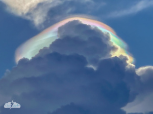
Iridescence in pileus cloud atop a growing thunderstorm in central Florida, Aug. 4, 2025. Photo by Chris Kridler, ChrisKridler.com
Pileus are short-lived wispy caps that form atop growing storm clouds, above strong updrafts. And I knew from previous experience that with the sun going down behind the building clouds, it was possible those pileus would display some iridescence. Or in the vernacular, they’d look like “rainbow clouds.”
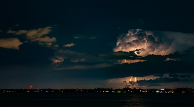
Cloud-to-ground (or cloud-to-ocean) lightning off Florida’s east coast.
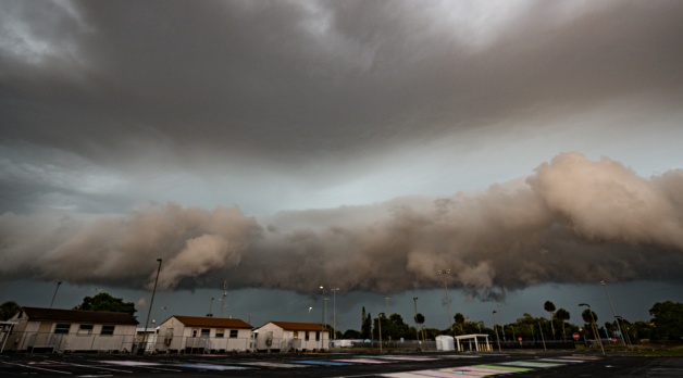
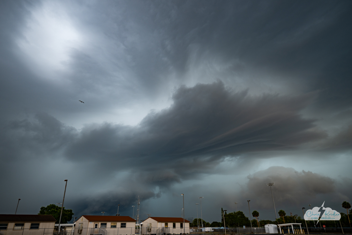
The storms merged and pushed out a shelf cloud as it was getting dark, so I ran out and got a few photos as this layered, gloomy beast moved across the Space Coast. The heavy rain and lightning followed.
I went out one more time after the storms had mostly passed and shot photos looking east over the Indian River Lagoon. I was surprised at how much cloud-to-ground lightning still sparked as the storms moved over the ocean. There were a few lightning crawlers, too; I missed a couple of good ones, but I included one of the lesser ones here. I cropped all of these lightning photos to show off the intricate and amazing detail in the bolts.
Click on any image to see a larger version.
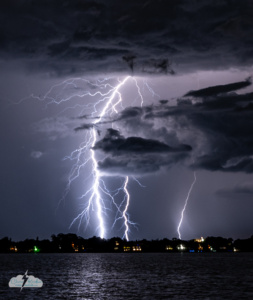
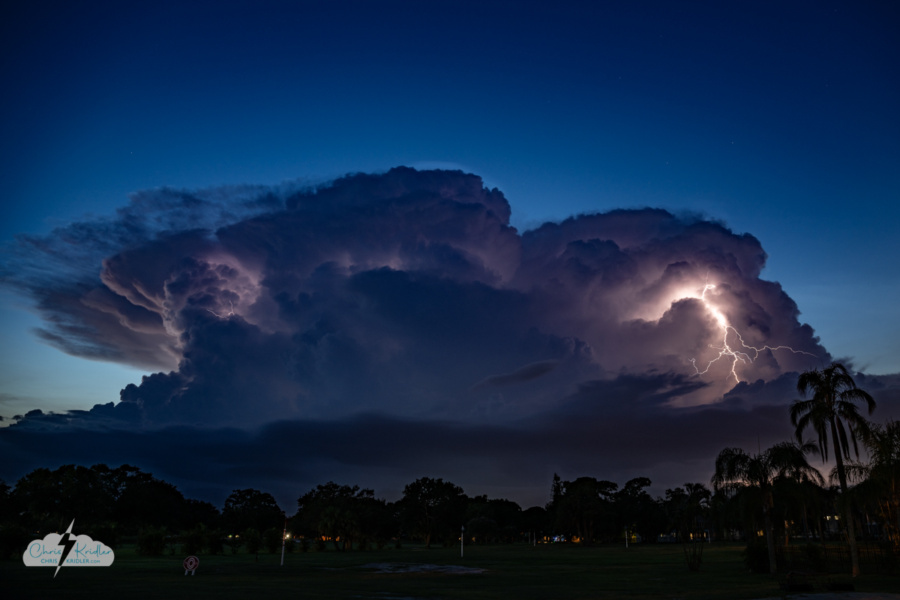
It’s been a weird summer here on Florida’s Space Coast. We’ve had weeks with no rain at all during the height of the supposed storm season, though this past week, we finally had some relief in the form of two gully-washer days in a row.
Tonight a couple of isolated storms popped up to our west, moving my way, and I realized I might have my first chance this summer for a local lightning chase. So I headed out to a favorite spot in Rockledge to capture the storms at sunset. For a little while, the storm popped with lightning almost continuously. Then it sent out what looked like an outflow boundary and clouds got in the way of my view.
Lightning storm as seen from Rockledge, Florida, on Aug. 3, 2025.
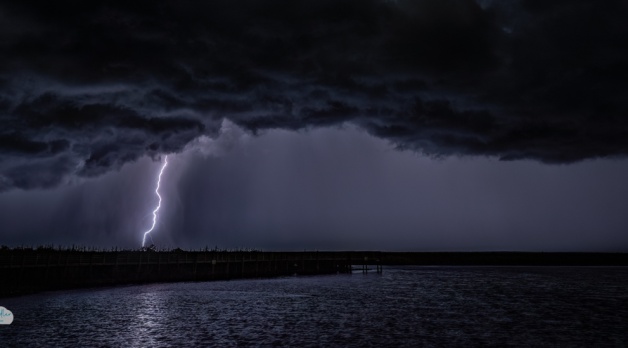
I moved west through Cocoa to a spot on the St. Johns River, hoping to get some cloud-to-ground lightning. As the storm weakened, there were a few bolts that I was pretty sure I missed. But I was luckier than I thought, and I was able to salvage a few so-so shots in editing. One was a blown-out bolt that was pretty spectacular, especially cropped as a vertical.
Here are a few shots from tonight. You can click on each thumbnail to see a larger version.
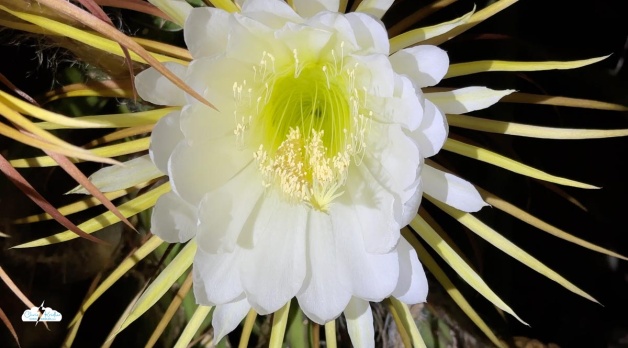
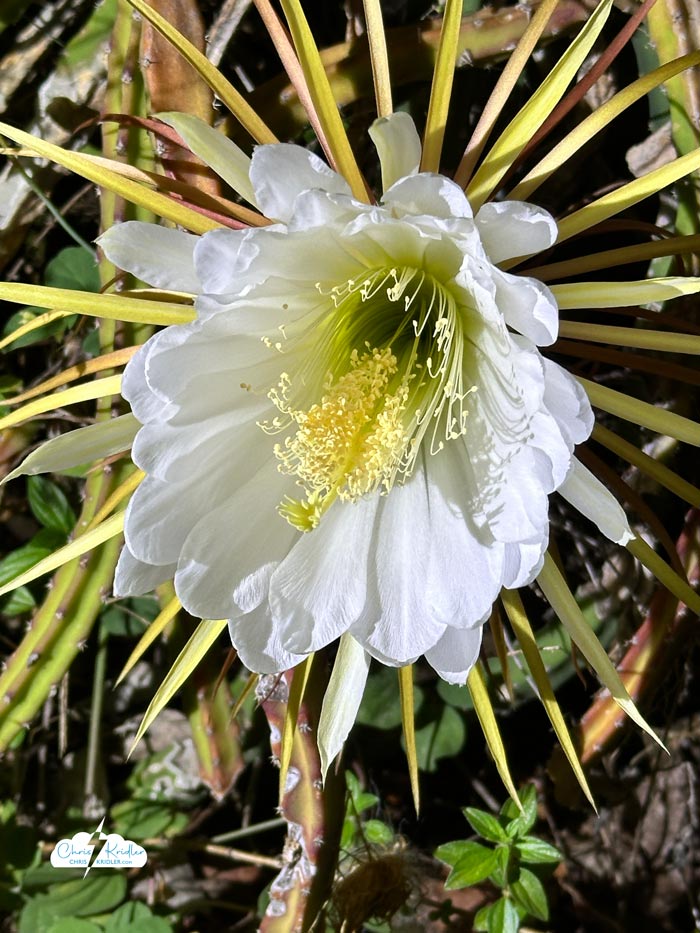
These showy night-blooming cereus flowers pop up on a cactus vine.
I missed the “big night” – there’s always one night when many, many of the blooms explode – because I returned from chasing storms the day after. But the blooms do appear for a while, popping up here and there. Until they don’t.
I’ve made several of these videos that you can see on my YouTube channel (please subscribe!), including a mini documentary that will tell you a little more about the blooms. This year’s video focuses on the mesmerizing beauty of one of these flowers as it opens. Check it out.
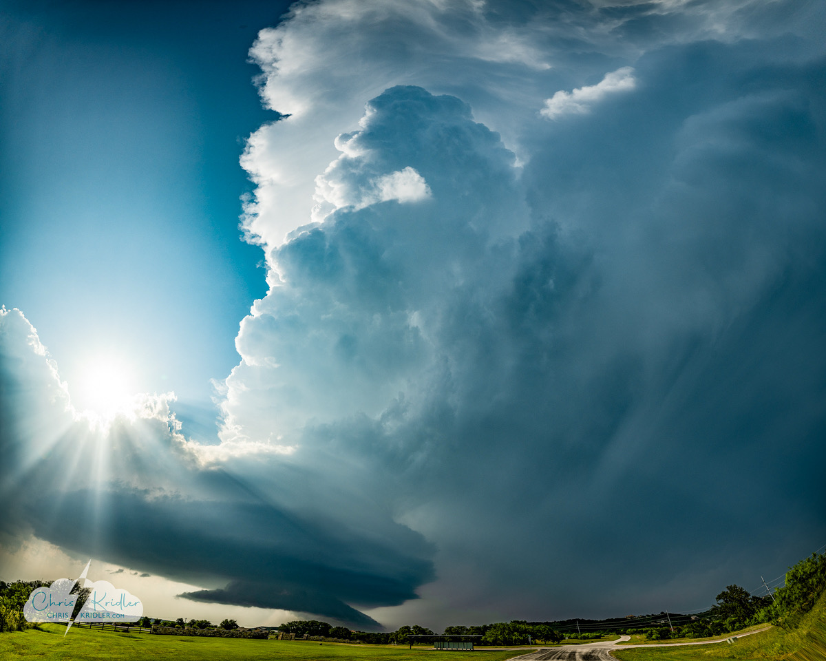
A supercell near Graford, Texas, on May 22, 2025.
We’re back from Tornado Alley! This trip with my storm-chasing partner Alethea Kontis went all too quickly, even though it was two and a half weeks. I sometimes wish I had the freedom to chase for a couple of months at a time, as some chasers do, but I still have a day job (editing books) and a fun job (writing books) and a husband and dogs and a life at home. So I enjoy the trip, and then I look for lightning when I get back home to Florida.
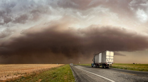
We saw five or six tornadoes, but most of them were in the “murknadoes” category — far away or difficult to see. The best tornado photo I got was probably a shot of a skinny little thing in Missouri, where I’d never seen a tornado before. And why “or six”? The last one was so murky, it’s super hard to see in my video, even though I think it’s there. All of this is to illustrate why seeing tornadoes is not really the most important thing to me when I chase storms, though I’m still frustrated when I miss them. Especially because our chase crew missed a couple of really photogenic tornadic storms due to bad decisions or poor timing. That’s the way the weather works sometimes and the way chasing works as well. Regardless, we still found beautiful storms to photograph.
One of the best things about this season — my 29th — was getting together with good friends whom we’ve barely seen in the past few years. Chasing together was a huge amount of fun. We hit thirteen states and drove more than 9500 miles, so we packed in a lot of adventure.
Alethea and I did several video updates from the road. You can check them out in this YouTube playlist. I’ll be posting more pictures and videos as I go through everything. I certainly got a lot of photos, and I can’t wait to share them with you. Thanks again to everyone who gave so generously to our gas fund! Stay tuned for more reports as I process all the images.
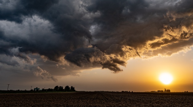
A pretty storm near Woodford, Illinois.
En route, we spotted the town of Metropolis on a map. I may have made a funny comment about Superman. We had no idea that when we stopped for gas, we were stopping in Superman central. The gas station was full of fun Superman stuff, and we headed downtown to a fabulous shop and an an awesome Superman statue. I still wish I’d shot a time-lapse of the beautiful clouds flowing behind it!
From there, we wandered around southern Illinois trying to get into position on a decent storm. The cells were pretty but not particularly powerful. But we saw a lovely supercell and a pretty golden sunset.
Here’s a closer look at the storm May 9 as most of the precipitation slid to the northeast.
This storm on May 9 wasn’t particularly powerful, and most of the rain slid by my location. But as storm cells merged, their structure evolved in an eerie and spectacular way. I snapped a few photos — see them below. Later, I tried to get lightning but went out a little late for the show.
Usually, if I get on a great, sparky supercell in the Plains, I prefer to do a time-lapse video. You can see some on my YouTube channel. Please subscribe to get the latest videos as I post them.
Coming soon, I hope: storms in Tornado Alley!
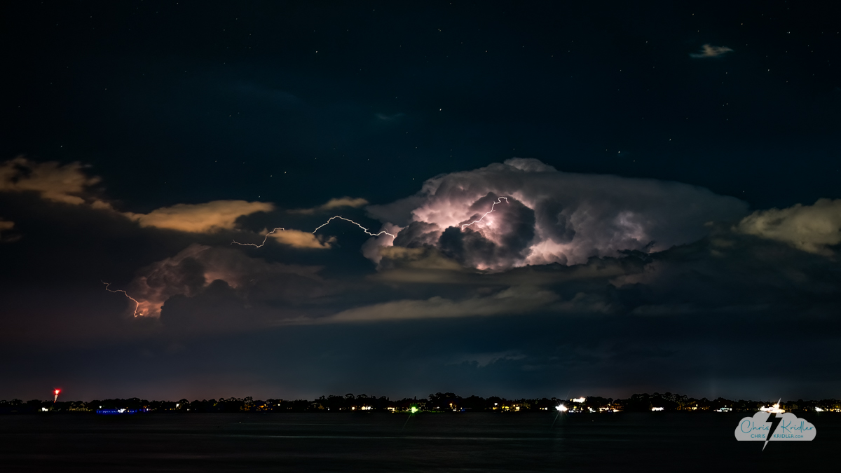
Lightning off Florida’s Space Coast on May 5, 2025, shot from Rockledge. Photo by Chris Kridler, ChrisKridler.com.
The thing about Florida storms is that they usually don’t last long, so I didn’t think it would be wise to drive all the way to the beach from the mainland to photograph it. I figured the cell would be dead by then. Instead, I found a spot in Rockledge on the bank of the Indian River Lagoon. There was some cloud clutter in the way, but the storm shot out some pretty nifty bolts regardless.
I was less than prepared. I had to crop the photos because I only brought one wide-angle zoom and the storm was a bit too far away. Obviously, I haven’t readied my gear for the Tornado Alley storm chasing trip yet, but that’s on the agenda this week. My storm-chasing partner Alethea Kontis and I will head out west soon. We’re looking for the next promising system. Stay tuned for more updates!
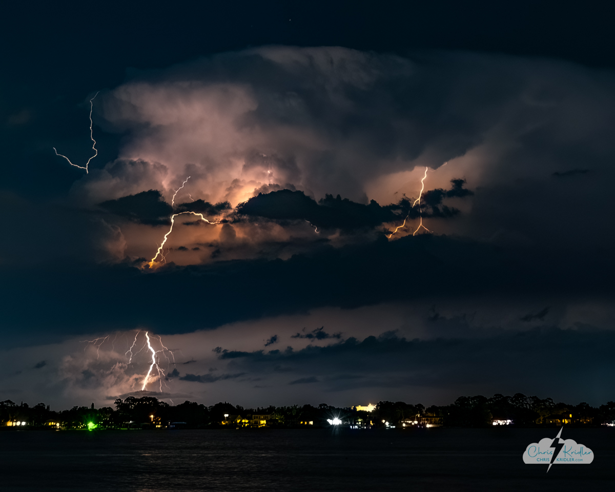
Lightning off Florida, over the Atlantic Ocean, on May 5, 2025. Photo by Chris Kridler, ChrisKridler.com.
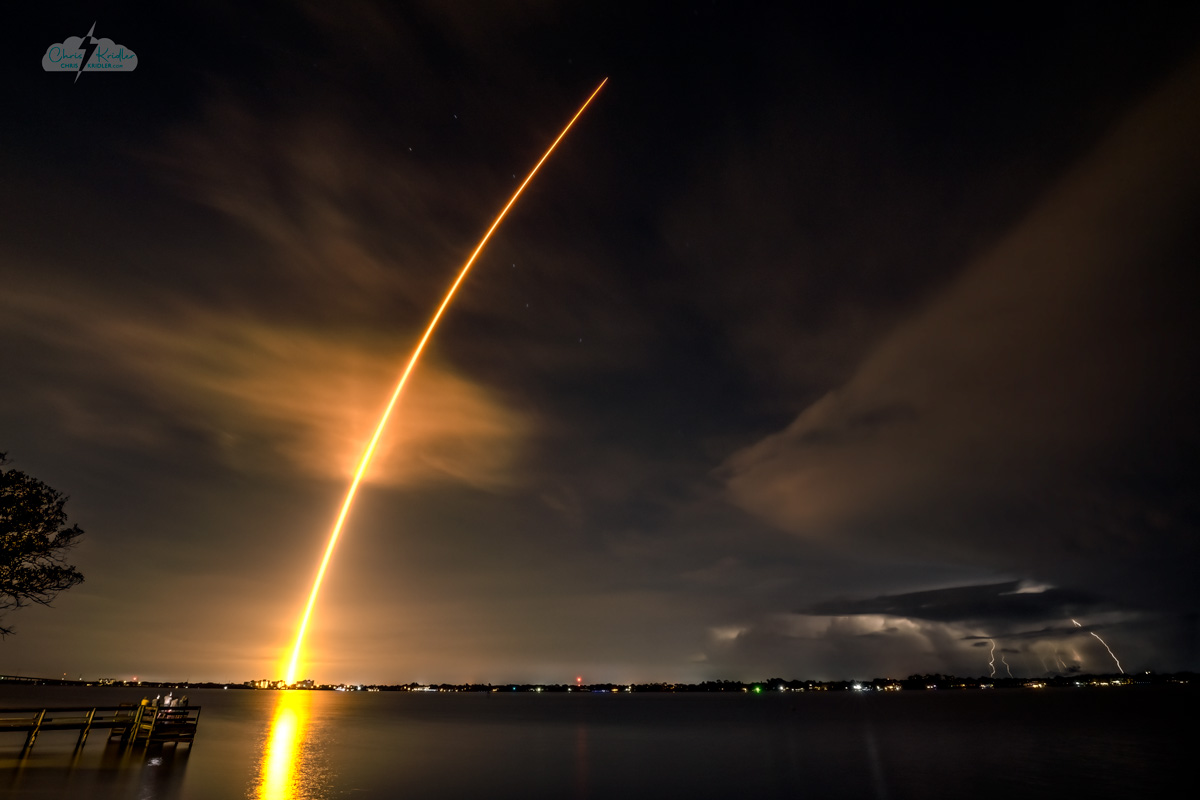
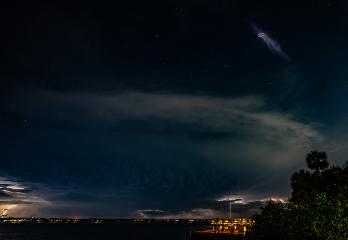
Falcon 9 rocket with the Fram2 polar orbit mission launches over a line of lightning storms on March 31, 2025, from Kennedy Space Center. Photo ©Chris Kridler, ChrisKridler.com
A line of lightning storms moved through the Space Coast tonight ahead of the launch of a Falcon 9 rocket with four civilian astronauts aboard. I was surprised the weather wasn’t an issue, but the rocket went high and south in a hurry. Still, I caught some lightning in the line in my time-exposure shot of the launch. The streak went right through the Big Dipper. Click on the photo to see a larger version in all its glorious detail.
I took this photo from the bank of the Indian River Lagoon in Rockledge, Florida, looking east. That’s the Rockledge city dock in the lower left, where people are holding up their phones to film the launch, and there’s lightning in the lower right. This was one exposure! I took several shots before the launch, thinking I might do a composite later, but no – the lightning cooperated, and I was able to enhance the image to make the bolts more visible.
Here’s one more shot at booster separation – a “jellyfish” effect in the upper right, with lightning in the lower left of the frame. Not as cool as the launch shot, but still pretty neat.
“Jellyfish” effect in the upper right from the Fram2 launch; lightning in the lower left. Photo shot in Rockledge, Florida, by Chris Kridler, ChrisKridler.com.
Girls Who Chase is a cool organization that aims to draw attention to women who chase storms and encourage girls to get into weather and the sciences. They also offer classes to folks who want to get into chasing. It was an honor to be featured with Alethea Kontis in their recent “Meet the Chasers” feature. We’re a rather eccentric duo in that, even though Alethea has science in her background and I have a great love of science and wrote about it as a journalist, we’re now writers of books (mostly) in real life. Check out the post to read the entire interview!
We also did a video to accompany the interview, which you can see right here. Thank you for the invitation, Girls Who Chase!


