
The following is a collection of six e-mail bulletins I sent to friends while I was chasing storms in spring 1998. I spent a month in the Plains — a week chasing on my own, two weeks with Cloud 9 Tours, and a week on my own again — and saw a fair number of storms, despite the uncooperative weather. Please note that the dates indicate what was imprinted on the e-mails and so may reflect a slight delay from when I wrote each bulletin.
Contents copyright 1998-1999 by Chris Kridler
Wednesday, May 13, 1998, 4:15:52 AM
I got into Oklahoma late Sunday night after a 15-hour drive from points East, and the last thing I wanted to do was drive way up into Nebraska the next day. But I thought, what the heck, that’s what I’m here for, right? I went up US 75 from Henryetta, OK, trying to at least get into the area at risk for severe storms. I was grateful to see clouds, at last, in northern Kansas, but no convection was evident and I hadn’t located a place to plug in my laptop to get more data. So I relied on an AM radio report of a tornado watch and headed west shortly after I got into Nebraska.
 I nearly gave up hope when I saw the tattered remains of a big storm, but I soon realized that several more were building. I headed further west toward one of them, and soon the radio station I was listening to was citing a Doppler-indicated tornado warning. But by the time I got near the storm, the warning had expired. Still, the lightning was amazing, and it was clear that major action was occurring, as I noticed another big “anvil” (blown off the top of a storm) to my south.
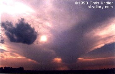
I decided that to intercept that storm, I should head south. Not too bright. I ended up right in the middle of it. Stunning lightning was striking far too close for comfort, and I was hammered with fierce winds, a blinding deluge and small hail. The clouds above were starting to look a little TOO interesting (since I was right under the roiling monster and didn’t know what it was going to do), so I was kind of grateful when I escaped its clutches. I ended up west of the storms. The view was breathtaking — huge cloud towers the color of Orange Creamsicles as the sun set, a fresh breeze, the birds twittering and a fantastic lightning show. Later, the full moon rose above the storms, still sparkling with lightning.
Today, I came back to Oklahoma… but it looks like I’m heading back up to Nebraska again tomorrow. (For the record … I wasn’t the only chaser who headed south only to find that the two-day forecast called for severe storms in the Northern Plains.) I need a chauffeur.
Meanwhile, I’m already sick of fast food and Waffle House-type establishments. There’s not enough garlic or Romaine lettuce in middle America.
Friday, May 15, 1998, 5:08:31 AM
Well, some days storm-chasing sucks. Take the last two days, for example. I put, say, a thousand miles on the car and saw far too much of western Oklahoma and the Texas panhandle, and for what? Well, let me tell ya.
Yesterday I didn’t really expect to see storms in theTexas panhandle, but in my driving around I saw a few cool, kitschy landmarks (a giant dilapidated cafe sign shaped like the state of Texas, for example). Clouds tried to build toward the end of the day but were flattened by the “cap” (temperature inversion). So I stayed at the lovely Motel 6 (NO WEATHER CHANNEL! the horror!).
Today, there was a much better chance for severe storms … a chance that got worse and worse as the day went on. I drove in hundred-mile circles around the Texas panhandle and western Oklahoma, trying to find the storms that were supposed to fire on the dryline. The cap was fiercely prohibitive, sitting on the clouds like a giant elephant. Making things especially difficult was a thick haze (and I thought Baltimore was polluted), the result of smoke from fires in Mexico and Central America. I was desperate. I saw some wandering chasers. I stopped for gas and ran into another storm chaser who hadn’t seen anything either. But a look at the radar (yes, he has two satellite dishes in his truck, ladies and gentlemen) revealed a tiny line of storms headed our way.
Here’s why this sucked. One, it was almost sunset. Two, the haze was blinding. In other words, there were storms (we even saw the billowing top of one), but because of very limited visibility it was pointless to go after them. Chasing severe storms at night is just dumb. They hammer you, and you can’t see anything anyway.
So, my friends, this was what storm chasers dread: a BUST! The worst kind of bust: a near-miss.
Thursday, May 21, 1998, 3:13:10 PM
If you want to know how bad food can get, go storm-chasing. Last night, in the thriving metropolis of Sidney, Nebraska, everything had closed by 10 p.m. And that meant truck-stop convenience-store food for dinner after a long day on the road. At least they had apples.
I’m with the Cloud 9 Tours group now for a total of two weeks. Despite what some chasers are calling a “thermonuclear cap” (the giant high pressure system that is only now inching eastward), we’ve had a couple of fun chase days already, driving all over eastern Colorado and southwestern Nebraska. We’re in the mountain time zone at the moment. In the slightly higher altitude here, it’s easier for the cap to break, allowing storms to form. And the front draped across the northern part of the country is helping.
On the way north Monday to get into position, we stopped to take photos of lightning and ended up driving through a storm that produced 55 mph wind gusts before we got in the cars … the winds were most certainly higher when we were driving through it. Tuesday we saw a few storms fire and fall apart, but they were pretty. Then, yesterday, we saw the best action so far: a huge rotating supercell that kept teasing us with lowerings and “wall clouds” (where a tornado is likely to form) … but it didn’t produce a tornado. Still, it was gorgeous.
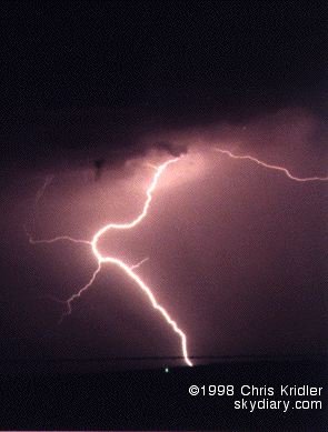
May 18, 1998, Kansas lightning
The weirdest thing about the tour so far is that a National Geographic crew is following us around, constantly sticking cameras in our faces and holding big fuzzy microphones above our heads in an attempt to eavesdrop. I was videotaping a storm Tuesday, turned around and found one of them right at my elbow with a big camera. Scared the hell out of me!
Looks like we’ll be chasing in the same general area today … or maybe a bit farther south. If the storms keep getting progressively worse, dare I hope for a twister by week’s end? Nah, better not. Then it certainly won’t happen.
P.S. I didn’t win the $195 million Powerball lottery. Rats.
Monday, May 25, 1998, 7:51:45 AM
Today — Sunday, May 24 — was the day the will be hard to beat.
We started in Norman, OK, with the idea of an almost leisurely drive of a few hours to a target area in northwestern Oklahoma. A stop to get some data in western OK in mid-afternoon showed that we should revise our target area a bit, so we aimed for Woodward, where in 1947 a giant tornado killed more than a hundred people and devastated the town. Woodward was lucky yesterday, but as we drove through the town we saw a big storm going up to our east. We had had “busts” three days running, and it seemed as if storms would never break south of the stationary front that’s been draped across the plains. Today, they broke.
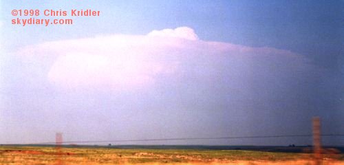 The storm was a loner. That’s an encouraging thing, because no other storms were around to steal its energy (or steal its thunder). It was feeding greedily off the heat and moisture that had been building in the atmosphere and was soon a big fist sticking up. Then it mushroomed, growing in mass and spitting out a big circular anvil at its crest. An overshooting top showed a strong updraft. This was a monster in the making.
We struggled to reach it as quickly as possible. Usually it’s best to see storms from the east, so that you can get into the best position as it goes by. But we had to approach it from the rear — from the west — and it’s lucky we did. This storm bordered on being an “HP bomb” — a high-precipitation monster that was likely to obscure its features with rain. We got into the heart of the storm before the rain hit us and were treated to a quick “gustnado,” a little tornado-ish thing that spins up but isn’t necessarily associated with the mesocyclone, or rotating area of the storm. Then, rapidly, two small tornadoes spun up in succession. They almost looked like big dust devils.
Then we got the really cool tornado.

 Though it wasn’t particularly strong, it was dramatic — it spun up a big bowl of dust just north of the road and soon was writhing with dark reddish-brown tendrils. It looked as if it was going to cross the road just east of us. Everything was happening very quickly. And then the wind knocked over a telephone pole about 25 yards in front of us and the tornado turned south-southwest — headed right for us. We were in the “bear’s cage.” The other tour van, which was east of the tornado, zoomed east away from the twister as it got within a hundred yards of us, making our big van shudder with strong winds. We got turned around, briefly spun our wheels in the slope off the road and sped west away from it. It was thrilling. It soon crossed the road, weakened and died. Another small tornado spun up south of the road, which was filled with a sudden convergence of storm chasers and cops.
We decided to head east to see if we could get around the storm and meet up with the other van, but complicating factors came into play — a couple of cops, completely clueless about what the storm was doing, slowed down the traffic by driving slowly in front of it. And as another big wall cloud (a lowering in the storm) began to show threatening funnel tendencies just south of the road, it became rain-wrapped — we were in the precipitation core, and soon we could barely see anything.
The cops let us go eventually, and we ended up driving through heavy rain and golf-ball- and plum-size hail, which repeatedly hit the van with big CLUNKS! We have a couple of good dents to prove it, and we stopped at a gas station to let some of it pass over us. It was chaotic. We took off further east, and it was getting pretty dark by this time — too late to chase storms safely, especially tornadic storms. North and west of us were also tornado warnings. As we drove down the road, I was in the front passenger seat of the van shooting video out the front window. Then… BLAM!
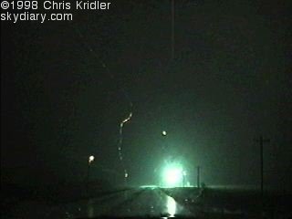

Lightning hit three telephone poles simultaneously in front of us — two on the left, one on the right. Sparks showered from the transformers. I got it on video. It’s rare to capture something like that on tape. What a rush!
The flash was amazingly close. On my video, when the lightning strikes, there is first a frame that is white — completely filled with light. Two bolts are apparent in the frame shown above, though sparks showered from three telephone poles. It’s possible that two poles were hit, one on each side of the road, and the charge on the left side traveled up the power line to cause sparks to shower from two transformers on the left, or north, side of the road. In one frame, you can see the remnants of the lightning and showers of sparks.
We eventually reunited with our colleagues, took a few lightning pictures when we got ahead of the storms and headed “home” to dinner and our hotel in Norman.
Friday, May 29, 1998, 2:17:24 PM
 SALINA, Kansas — We’ve had a couple of days of BAD weather. Sunny skies, high heat. There’s a chance of storms today, but based on the data, I’m not getting my hopes up. Still, a couple of days ago, I got to see what the effects of an F3 or F4 tornado are really like.
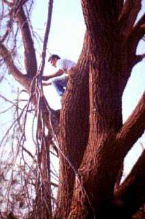
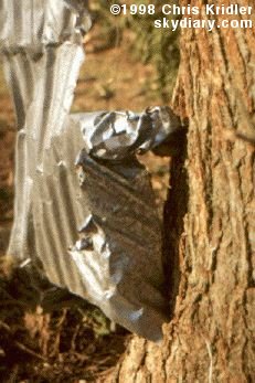
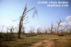 Our group went to Lamont, Oklahoma, where a half-mile-wide tornado — spawned from the same storm that produced the tornadoes we saw — seriously damaged several houses and blasted trees so that they looked as if they’d been through a firestorm. I saw the kind of legendary tornado “tricks” that people talk about — including pieces of hay and corrugated metal shot into trees.
Sunday, June 7, 1998, 2:32:58 AM
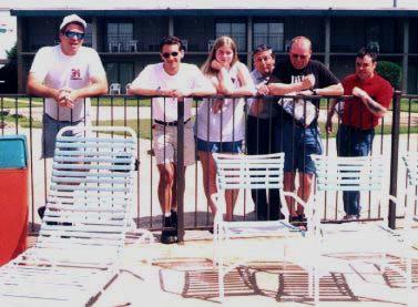
Cloud 9 Tours chasers
I wrapped up my last week in Tornado Alley with a truly pathetic chase … but then again, there wasn’t much more available to me. This season has been dreadful!
Wednesday I ended up in Joplin, Mo., thinking I’d be in position for a chase the next day. Thursday morning, it looked to me like extreme mid-eastern Oklahoma and northwestern Arkansas would be a good place to chase — except that the geography makes it a very bad place to chase! Hills, mountains, trees — very pretty, but impossible to see anything, and the road network is abysmal. Still, the data showed some potential and I was desperate. I began the day with a leisurely drive south through the Ozarks. When the Storm Prediction Center started talking about “significant supercells” and using the “T” word, I began frothing at the mouth. Or maybe it was the vanilla milk shake at the truck stop in Fort Smith.
I roamed north and saw some pretty convection in the Bushy Mountains area of eastern Oklahoma. It soon appeared the cap was breaking with towers to my northeast. I crossed into Arkansas, but what looked impressive quickly proved to be fool’s gold. I was in the middle of the tornado watch when it was issued, but a lot of good it did me! I saw little more than hard rain and a few brilliant CGs (cloud-to-ground lightning), though several severe thunderstorm warnings went out and somebody reported quarter-size hail. It was a very messy cluster of storms along the cold front, and what storm structure there was was difficult to make out.
I probably should have chased in Texas Friday, but didn’t deem the chances for big weather thrilling enough … especially since I had to drive home sometime this weekend (and I just know all hell is about to break loose in the Panhandle, now that I’ve left!). Like a possessed person I drove straight through from Joplin to the Baltimore area in 17.5 hours. It’s cool here, mostly sunny, and I’m desperate to return to the Plains. However, I got my first decent sleep in a month, got my sushi fix, and found out that I even lost a couple of pounds on the chaser diet. Small comfort for vacation’s end.