Chris Kridler
Chris Kridler is a writer, photographer and storm chaser and author of the Storm Seekers Series of storm-chasing adventures.

Chris Kridler is a writer, photographer and storm chaser and author of the Storm Seekers Series of storm-chasing adventures.

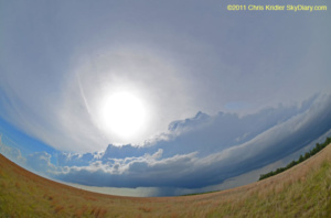
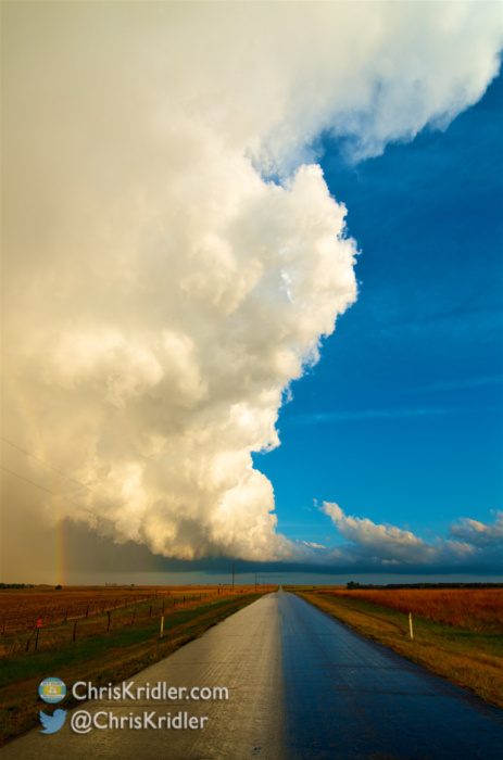
The May 29 storm was pretty until it died. Photo by Chris Kridler, chriskridler.com
May 29 was yet another cap bust, as storms were eventually defeated by the capping inversion, the warm temperatures above the surface. I’m exhausted, and tomorrow is likely my last chase day on this trip, so I’m going to get some sleep.

Sunset behind a windmill in Kansas on May 25, 2011. Photo by Chris Kridler, chriskridler.com
What does one do while driving thousands of miles and, as has happened the last two days, busting on storm chases? Take a few pictures. I wish I’d taken more, but so much time is consumed by actually getting from one place to another. The freakin’ distances out here are massive.
Keeping it brief: again, too much driving after busting in Colorado yesterday. I’m waking up in Salina, Kansas, after that very long round trip. I kind of knew I was in trouble when all the cloud cover manifested over my target area yesterday, but I figured, I was halfway there, so why not go for it? The thing is, “halfway” when you’re talking about driving to the front range is pretty dang far. The scenery in eastern Colorado is lovely, though, spare and ascetic. Today, the target is central Oklahoma, though this won’t be one of those crazy outbreak days. This is kind of a “maybe” day. I can feel my trip beginning to wind to a close. I still haven’t decided whether to chase marginal chances this weekend or begin heading home for Florida’s lightning season. There’s no place like home! Click, click, click …
The potent tornado machine is slowly moving east, losing a little of its punch, though my friends in Pennsylvania should watch the weather today. Florida might get storms, too. I hope we get rain at home to keep the plants happy!

This was the second tarantula I saw crossing the road in southeast Oklahoma on May 22. Photo by Chris Kridler, chriskridler.com
I chose not to chase in the hills and trees yesterday and instead repositioned north and west. I plan to go into Colorado to see what storms I can catch today. I’m looking for a little of that upslope magic.
I’m slowly catching up on my chase reports. [Note: This part of the old SkyDiary website is gone now.] The latest addition is the day of the Joplin, Missouri, tornado, which I did not chase, instead choosing to go after a promising area in southern Oklahoma. Again, it meant fewer hills and trees, and that’s a factor in the decisions that chasers make sometimes. Visibility is important. That day I also saw the TIV and the Dominator on the road, which you may have seen in Discovery’s “Storm Chasers” show. I saw storms that day and, of all things, a couple of tarantulas!

Storm Prediction Center early outlook for May 25.
People seem transfixed by the damage and deaths from this year’s insanely deadly tornado season, including the May 24 outbreak. I wish more people had been glued to media yesterday, when it might have saved their lives. But some of the tornadoes would not have been survivable unless people were underground. It was also extremely hazardous and difficult chasing. “Our” storm produced a beautiful tornado just before we arrived, and then we were behind the curve. I dallied to see a second line of storms forming, and by the time it collapsed, it really was too late to get ahead of the line, which was moving at highway speeds and offered no safe places to squeak around the big tornadoes they were dropping. I didn’t have the will to punch the core of these monster storms.
I’ve never seen a setup like that while chasing in the Plains. Compared with the May 3, 1999, outbreak, another famous day of destruction in Oklahoma, my understanding is that these tornadoes were moving faster and were more numerous and much harder to see. Several were wrapped in rain. Nonetheless – I’m not the only chaser who didn’t see much May 24, but I still feel bad about it. Today’s setup is almost as volatile, but farther east, in more difficult chase territory. I don’t think I could get into play before the storms go up, given that I’m in Norman, Oklahoma, this morning. By the way, I’m extremely glad Norman is still here. When the warnings were coming out yesterday, it sounded as if it might be wiped off the map.
On a better note, I had a fantastic day May 23, when I saw a slim tornado, a beautiful low-precipitation supercell, hail, flooding and lightning. All without worrying about tornado-geddon!
With several friends, we targeted northwest Oklahoma.
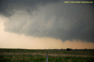
23 MAY 2011 – Tornado at Okeene. The swirl of dust/tornado persisted for a couple of minutes. Photo by Chris Kridler, chriskridler.com
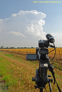
23 MAY 2011 – I filmed the growing storm to the south. Photo by Chris Kridler, chriskridler.com

Aftermath of storm with mammatus in Kingfisher, Oklahoma, May 23, 2011. Photo by Chris Kridler, chriskridler.com
23 MAY 2011 – I loved this spectacular crawler. Photo by Chris Kridler, chriskridler.com
The Storm Prediction Center has issued a high risk for today for the heart of Oklahoma. Southern Kansas is also in the target area. Wind profiles today are insane, and those and other parameters suggest a tornado outbreak is possible. So I am feeling a mix of dread and excitement … dread for those who live here, and excitement (and anxiety) about the chase. The storms are likely to be moving at scary speeds, so it will be a challenge.
In favor of getting a few hours of sleep, I didn’t post pix from yesterday – May 23 – which was a wonderful chase day. I saw a slim tornado, hail, flooding, a gorgeous structured storm, and lightning.
I hope everyone has their weather radios on today. Heed warnings.
End of day update: Ugh! The storm we targeted in northwest Oklahoma produced a beautiful, huge tornado over a lake – shortly before or about the time we got to it. Unfortunately, terrible visibility and bad timing meant we didn’t see it. Two of our party went into the precip core to see a subsequent rope tornado, but I didn’t, and the rain obscured it. And then I was caught behind the line of storms as they screamed east at highway speeds, dropping massive and destructive tornadoes in some cases, often wrapped in rain and invisible. Some chasers “saw” but didn’t see these wedges; at least one friend nearly was killed by one. In a way, I’m glad I didn’t get aggressive and try to punch that line, but I’m disappointed I didn’t see more of this historic outbreak, and I am saddened at all of the destruction and loss of life. This has been a terrible year for tornado deaths.

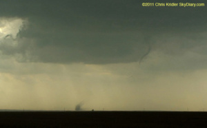
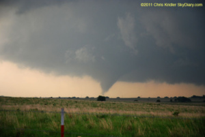
This May 21 tornado near Sulphur, Oklahoma, briefly touched down. Photo by Chris Kridler, chriskridler.com
I’m almost caught up on storm-chasing photos (after staying up half the night again). I saw severe storms Sunday, but not much to write home about, though I will post a few photos eventually. I was saddened to hear of the devastation in Joplin, Missouri. Some of my chaser friends were on the scene and helped victims of the tornado.
In the meantime, I have posted photos of the beautiful Kansas storms of May 20 and photos of the southeast Oklahoma tornadoes of May 21.
[Note: the old galleries at SkyDiary.com are gone, but here are a few photos from those pages.]
May 20, 2011: I had a glorious chase in southern Kansas today, as minor storms firing off the dryline offered lovely photo opportunities as they gained strength. I started with a big group of friends, but the company soon narrowed to Jason Persoff and Robert Balogh as we split in different directions around the storms. We kept going after the southern storms forming on the line, all in the vicinity of Pratt, Kansas.
20 MAY 2011 – The Storm Hunters van (Mark’s crew) in Greensburg. Photo by Chris Kridler, chriskridler.com
20 MAY 2011 – The storm was a beauty. Photo by Chris Kridler, chriskridler.com

One of my favorite photos from May 20.
May 21, 2011: I targeted Ardmore in southern Oklahoma today as a starting point, due to a potentially favorable spin in the atmosphere and huge instability, among other things. When I got there after driving from Wichita, I couldn’t help driving just a bit farther to Marietta, just north of the Texas border. (Also, I left the Ardmore truck stop because a skunk was wandering around, and I’d almost stepped on it when I attempted to get out of my car.) I was anxious over an already-reported tornado on the ground in Texas, but like everything in Texas, it was really far away. I chose to remain in my target area, watching cloud towers push up and break apart – until one started to look as if it meant it. It had crisp, billowing convection and began to cut a gorgeous shape in the sky. When I got up close enough to see the base, rotation was evident. At first, it had a multi-vortex appearance and produced a couple of needle funnels in this mode. Later, it put down short-lived tornadoes. And much later, as this storm died, another to its north produced a tornado just outside Ada, Oklahoma. I got to it just in time.
21 MAY 2011 – First, a needle tornado touched down near Sulphur, Oklahoma. Photo by Chris Kridler, chriskridler.com
21 MAY 2011 – Its tendrils twisted on the ground. Photo by Chris Kridler, chriskridler.com
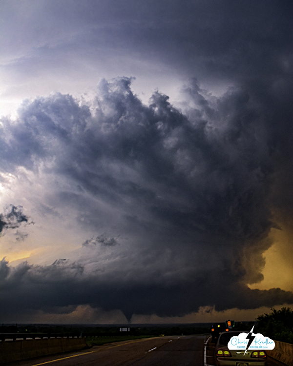

Tornado at Ada, Oklahoma, May 21, 2011.
Chasing in southeast Oklahoma is a special kind of challenge. I was reminded of this fact as I spent a few minutes twisting through the hollers, my view completely obstructed by trees, as a tornado-warned storm that had already produced funnels was moving somewhere over my left shoulder. Nonetheless, that was my target today, due to a potentially favorable spin in the atmosphere and huge instability, among other things. Ardmore, specifically, I viewed as a starter point, but when I got there after driving from Wichita, I couldn’t help driving just a bit farther to Marietta, just north of the Texas border. (Also, I left the Ardmore truck stop because a skunk was wandering around, and I’d almost stepped on it when I attempted to get out of my car.) I was anxious over an already-reported tornado on the ground in Texas, but like everything in Texas, it was really far away. I chose to remain in my target area, watching cloud towers push up and break apart – until one started to look as if it meant it. It had crisp, billowing convection and began to cut a gorgeous shape in the sky. When I got up close enough to see the base, rotation was evident. At first, it had a multi-vortex appearance and produced a couple of needle funnels in this mode. Later, it put down short-lived tornadoes. And much later, as this storm died, another to its north produced a tornado just outside Ada, Oklahoma. I got to it just in time, and this photo shows the structure of the storm with the tornado on the ground under it. I’ll be posting more photos later, but once again, I am extremely sleep-deprived and anticipate more driving and chasing tomorrow and Monday. I hope I can find a few minutes (really, a few hours) to post photos soon.
A storm passes over the road May 20 at Cairo, Kansas, leaving it glistening with the reflection of the cloud, which is lit by the setting sun. Photo by Chris Kridler, chriskridler.com
It’s about 4 a.m. CDT, and I’m making this post fast, so I can get to sleep. I had a glorious chase in southwest Kansas today (May 20 is still today for me, at the moment), as minor storms firing off the dryline offered lovely photo opportunities as they gained strength. I started with a big group of friends, but the company soon narrowed to Jason Persoff and Robert Balogh as we split in different directions around the storms. We kept going after the southern storms forming on the line, all in the vicinity of Pratt, Kansas. Here is just one shot; I have a lot more to post, but time ran out tonight after trouble on the road.
Just 10 miles west of Wichita late at night on the way into town and to our hotel rooms, Jason hit a deer. Or maybe we should say the deer hit Jason. Either way, Jason was OK, but the deer and the rental car were both in bad shape. Many phone calls, the kind attention of a wonderful police officer, and a tow truck later, and all Jason’s stuff was in Robert’s and my vehicles, and we were able to get under way again. We got in about 2 a.m., and it’s taken me forever to get all the photos off my cards. I just don’t have time to process them all tonight before lapsing into unconsciousness, so … more later!
The prospects seemed good today for tornadic supercells, the kind I’ve been waiting for, especially in south-central Kansas. Sometimes, you take a chance on an area where you hope for long-lived, photogenic storms rather than going after the other stuff. Today, it was all “other stuff,” as storms fired off the dryline and zoomed north, prompting a few unimpressive tornado reports. (To clarify: Yes, there were tornadoes, just not what I hoped for.) But meeting other storm chasers was fun.
You can’t always get what you want. Today, I don’t think I got what I needed, either – I’m still looking for Mr. Goodstorm, the supercell that will make this trip photographically worthwhile, before I go broke.

Turkey towers loom over storm chasers in Saint John, Kansas, as they await real storms May 19. Photo by Chris Kridler, chriskridler.com

19 MAY 2011 – The chase began with a meal at this awesome diner in Pratt, Kansas, now called The Famous Servateria, with chasers Bill Hark and Robert Balogh. I love this populuxe sign! Photo by Chris Kridler, chriskridler.com
19 MAY 2011 – Chaser convergence in Saint John. Photo by Chris Kridler, chriskridler.com
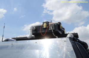
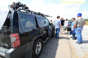
19 MAY 2011 – Waves of chasers came and went, and then Dave Lewison and Scott McPartland (their roof cam is shown), along with Mark Robinson and his crew, arrived. Photo by Chris Kridler, chriskridler.com
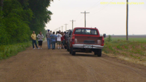
19 MAY 2011 – Our target storm died as we approached, prompting a chaser conference on a remote road. Photo by Chris Kridler, chriskridler.com