
I am disturbed and amazed at the wave of tornado onslaughts … and now flooding, too … all in the same area. People keep asking me why I’m not there. Many chasers are seeking and finding the storms, but many tornadoes are occurring in what is referred to as “the jungle,” because of the hills and trees. In other words, visibilty is low, making it extra hard to track the storms. And of course, the people who live there can’t see them coming, either. If you are in the danger zone, leave your weather radio on. It will give you the best and fastest warning.
Much wiser storm chasers than I have said, “Live by the models, die by the models.” But one must live a little by the computer models in order to figure out when to make the (ideally) two-day drive out to Tornado Alley. I’d much prefer chasing storms in the lovely, flat, empty expanses of the Alley than in the trees and hills and populated areas where tornadoes have been wreaking havoc for the past few days. When I live as far away as I do, it becomes somewhat of an expedition to get all the gear ready, load up the car, and get the heck outta Dodge. Or to Dodge – I’ve passed through Dodge City, Kansas, almost every year of chasing, it seems. It smells like cows.
That said, I’ve ordered a rental cell modem so I can get data while mobile. It’s a long way from the days when I had to plug into a phone jack at a truck stop and sign on to the Internet that way to get data – and that was awesome. Granted, you can’t get mobile data everywhere, but it’s amazing where you can get it.
Anyway, I’m starting to get everything ready. I’m working my last few days as a full-time newspaper reporter this week, as I begin a freelance career. And I’m trying to find a missing camera battery. You haven’t seen it, have you?

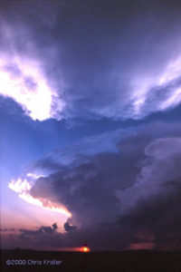
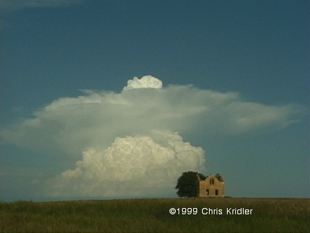
A turkey tower (ambitious cloud) even sports a few mammatus as it moves east with a boundary in Rockledge, Florida, on April 12, 2011. Photo by Chris Kridler, ChrisKridler.com
I drove slightly out of my way this evening to get about 10 raindrops on my windshield as a front pushed through the area. I was hoping for a little more excitement, especially after I saw some, you know, clouds. I talked with my friend Steve Sponsler, who writes a great forecasting blog that focuses on Florida. He feels his forecast verified, because, after all, there was rain.
This time of year, it’s easy for storm chasers to obsess about the weather. I haven’t been, because I’ve been busy trying to finish up things at my job so I can start working for myself. But the obsession is about to begin, since storm chasing is just a few weeks away. I have a lot to do in terms of getting gear in order, and just getting in the mode of daily forecasting, too.
Well, tonight’s “chase” was rewarded at home, when this ambitious little turkey tower, complete with a few mammatus, pushed east overhead at sunset. It wasn’t powerful, but it was pretty.

A dog gets a sheep in line during a herding trial at Asher-Dell Farm in Malabar, Florida. Photo by Chris Kridler, ChrisKridler.com
This is why I love taking photos of animals: They are constantly moving, so a great photo feels like a rare event (not unlike taking photos of children). They are full of life and personality. If they look you in the lens, it’s always a moment. And they and their people are fun! A couple of months ago I went to a herding trial at Judith Kelly’s Asher-Dell Farm in Malabar, Florida, and I had the opportunity to shoot the trainers putting the dogs (and the sheep) through their paces. The dog in the photo was taking no nonsense from these sheep.
Hubby just made a Puhi Split. This sounds more gymnastic than it is. It’s a wonderful cocktail with macadamia nut liqueur, dark rum, Kahlua and cream. Oh, and fresh banana, blended with ice. Amazing. He found the recipe on Tiki Central. That Trader Vic’s Macadamia Nut Liqueur is serious girl-drink goodness, but the guys like it, too.

Easter cocktails: Blue Egg, Green Egg, Pink Egg (courtesy Deussen Global)
It’s been a busy week for cocktail press releases in the mail. I know, these recipes are just designed to push certain kinds of liquor, but don’t they look good? Of course, I am somewhat suspicious of “elixir”-colored drinks, as the recipes designate, and I don’t generally consider Easter a big drinking holiday, but some would argue that every holiday is, especially those spent with large, dysfunctional families. I found at least one of these recipes, the Blue Egg, elsewhere online under a different name. The Blue Egg features vodka; Green Egg, absinthe; and Pink Egg, rum. What do you think of strangely colored drinks? I love Beachbum Berry’s take on the Mai Tai: “A Mai Tai should not be red. A Mai Tai should not be blue.” But judge for yourself; here’s the Green Egg: Combine 2 ounces Lucid Absinthe; 0.5 ounce lime juice; 1 ounce Coco Lopez; and Teal Elixir #5 in a shaker with ice. Strain into a tall rocks glass with ice and top with Lucid Absinthe. Garnish with a lemon, lime, and maraschino cherry.

Bakon Vodka Bloody Mary
Also this week, I got a press release congratulating me, because at last, in Florida, Bakon Vodka is available. It tastes like – yeah, you guessed it. They recommend it for Bloody Marys.
Another press release offered the Bringing Home the Bacon: Rim a shot glass with maple syrup and cover rim with bacon bits. Fill the shot glass with Hornitos Anejo (or the tequila you prefer). Simple enough. Bacon. Not just for breakfast anymore. Or maybe tequila is for breakfast? You decide.

Champagne cocktails. Oh, the joy of tiny bubbles.
I’m in the process of doing our taxes, which means reviewing a year’s worth of expenses, and they can be kind of disturbing when grouped into categories. Especially “Restaurants.” One of our credit cards had enough restaurant expenses that they could be traded for a small used car. Granted, many of these were accrued as I reviewed restaurants for Florida Today, but given I had a limit even on those expenses, it still means we dine out a lot. I think as I become self-employed we will still enjoy dining out, but I hope we’ll also have time for more gourmet prep at home. And I still love shooting pictures of food and drink. This photo was from a holiday/champagne cocktail shoot in FT’s television studio.

The dogs are ready to sleep. I am, too.
I still have a lot more I want to do with the site, but a girl has to sleep sometime. Stay tuned, and you will see the design evolve, particularly on the gallery pages.
This is Chris Kridler, and I’m just starting to develop a portfolio and blog web site to complement my storm-chasing site at www.SkyDiary.com – check it out to chase the storms!
Here’s a collection of bulletins from the field, written during my 2000 storm-chasing trip in the Great Plains. They are slightly edited. Dates reflect when each bulletin was written.
JUNCTION CITY, Kansas … May 10, 2000
Chasing storms is a bit like playing chess with the sky when all you know is checkers. The sky, unpredictable and complicated, always wins.
There hasn’t been much to chase so far. I set out Saturday from Florida for parts west — a 15-hour drive that put me in Monroe, Louisiana, for the night. The highlight was entering Mobile, Alabama, over an expanse of water, on a long, curving road at twilight. The sky was deepening into dark, and the highway was punctuated with street lamps, strung out before me like beads on a necklace. The low point was a psycho trucker who was harassing me by rushing up to get on my bumper, passing me, slowing to a crawl, waiting until I passed him, and then beeping at me. This happened several times until I got off the highway and took a little nap at a rest stop. I needed it anyway, as sleep-deprived as I was.
The second day’s drive … only eight hours … got me to Norman, Oklahoma. The next morning, after seeing some of the old faces from Cloud 9 Tours, Dave Lewison and I set out. We drove around in circles for hours and hours, trying to play a warm, moist area ahead of the cold front in central Oklahoma. Instead, a few storms broke out behind the front near nightfall, but considering the distance we had traveled and their relative wimpiness, they didn’t seem worth lingering over. We saw a few flashes of lightning in the storms, north of Oklahoma City, as we set off for Lubbock, Texas, where I had to do some interviews for my paper the next morning. We arrived just before 4 a.m. More sleep deprivation!
At Texas Tech, we got to see the sensor-studded building that researchers rotate to face into the wind. We talked to some knowledgeable folks about the latest in storm shelters. We also saw a few dust devils in a field outside town. Dave “punched the core” of one — running into it, that is. He was brushing away dust all day afterward. This is what storm chasers do for off-day excitement.
Today was a gruelling drive in anticipation of marginal storms that never showed up. We realized that would be the case by mid-afternoon but wanted to get into position for tomorrow. The problem is, tomorrow’s chances are way the heck east — Iowa, Minnesota, even Wisconsin — and I don’t know if we can make it from here, near Manhattan, Kansas. So we’ll have to decide after looking at data in the morning.
At least it’s good to be roaming the Plains again. We’ve been through one small town after another, dusty monuments to perserverance that fall apart a little more every year as the wind howls across the flat, desolate and strangely lovely land. There was the historic windmill park in southwest Oklahoma… the Kinsley, Kansas, sign marking the “Midway U.S.A.” point between New York and San Francisco … a sign for “Shotgun Dave’s Viking Barbecue” … a little Kansas carnival … the faux dinosaur that sits atop a hill in the northern Texas panhandle … long trains that snake through the hills and over the flats … a water tower in central Oklahoma that looks like a peach (but not like the famous butt-shaped peach tower of Gaffney, S.C. — thank goodness).
We shot some pictures today of a burnt orange sun setting behind a pumping oil well. It was a cliche, but a beautiful cliche.
Tomorrow … who knows?
SALINA, Kansas… May 15, 2000
We’ve been driving so much, I’ve hardly had time to write a thing. But here we are, in Salina, Kansas, on the eve of another chase day.
 Last Thursday, Dave and I targeted northeast Iowa. Low pressure was moving into the area, which would cause the surface winds to come from the south or southeast, while upper-level winds were streaming in from the west. The result: shear in the atmosphere, meaning if a storm went up — and it was likely where the warm and cold fronts met — it would probably rotate.
Dave and I found ourselves in an area with a 74-degree dewpoint and promising cumulus clouds that were starting to bubble up and bump against the warm layer of air known as the cap. One area seemed particularly promising, as the towers became hard and aggressive there before collapsing. They got bigger as time went on. It seemed that any moment one might burst through. We sat on a dusty farm road west of Grundy Center and waited, with phone calls to Steve Sponsler and Cheryl Chang back in Florida confirming that we were in the right place. About this time, California chaser Mark Aubin met up with us.
Then the beast exploded.
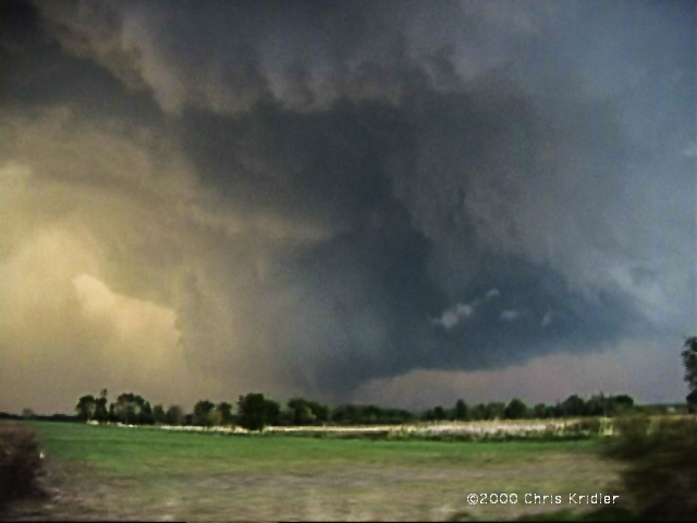
This is the storm that would produce a damaging tornado in Dunkerton. The truth is, it was a tornado machine. As we pursued the rapidly expanding cell, heading north to catch up with it, we saw it developing a succession of rotating wall clouds and kicking up dust. Unfortunately, we missed the first two powerful tornadoes as we found ourselves stuck in the town of Waterloo. Navigating around it cost us valuable time and position. We had no idea a couple of giant tornadoes (as seen on The Weather Channel) were chewing through an area well north of us. The chasers who saw those tornadoes punched into the storm from the north.
Our efforts were not in vain, however. We navigated a series of gravel farm roads to keep up with the beast, which had several mesos — mesocyclones or areas of rotation — at once. While we watched the storm, Dave watched it on his tiny TV too — a crazy man in a helicopter was flying around the supercell, filming it for a local television station. The first obvious tornado that we saw was backlit by lightning and produced a bowl of dust under the meso. It also produced a fast, white satellite funnel that orbited around the main funnel — one of the most amazing things I’ve seen. It was a multiple-vortex monster. The storm produced another tornado near the multiple-vortex funnel, then another one in a field just to the east … and very near us.
It was getting dark at this time. We thought we’d attack the western portion of the storm, where it looked promising on radar (as seen on TV!), then changed our minds and headed east to keep up with the leading edge. I got some eerie video near Manchester of some suspicious-looking clouds looming over the land, seen in brief moments, lit by lightning flashes, as tornado sirens went off. I am pretty sure they were “scud” clouds, raggedy clouds on the leading edge of the storm, though they had a funnel shape. We heard damage reports from Dunkerton and realized we’d missed some of the tornadoes, but we’d seen a storm of tremendous and humbling power.
Friday was hardly worth the drive into Illinois. Though we were in the midst of multiple warnings, we could see almost nothing because of the haze, mushy clouds and precipitation. And struggling against the heavy traffic in populated areas didn’t help either. It became a war of attrition. We were in Mattoon when the sirens went off, with a screaming south wind blowing horizontal rain at us. That suggested there might be a meso nearby, but we couldn’t see crap! We got some marble-sized hail and saw some hot lightning out of the storms, then headed back west. Frankly, I was relieved to cross the Mississippi again and spend the night in Missouri. The next day, we were back in Oklahoma.
The annual storm chaser party was Sunday in Texas, at Storm Track editor Tim Marshall’s palatial home, where we saw lots of chasers and lots of video. It was a true geekfest, and there were very few women present. I interviewed a few chasers for a Florida Today story about gear and gadgets — boy, do I feel ill-equipped now.
Now, we await what a huge trough will bring to the Plains in the next couple of days. I expect we’ll head to western Nebraska tomorrow. The skies could get really violent by Wednesday. Or not.
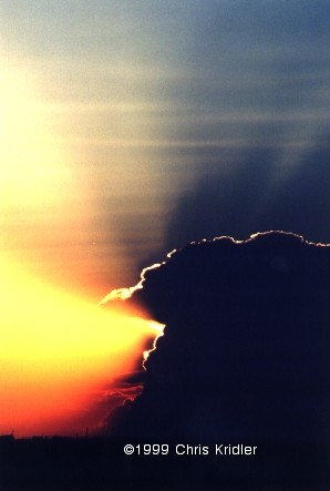
It’s all about the moment. An orange sunset. A green wheat field. A stroke of white lightning slicing open a midnight sky.
I have no idea what’s next. I like it that way.
FORT WORTH, Texas … I-35, en route to Abilene … May 19, 2000
There’s nothing like a really good day followed by a really bad day. The really bad day makes you forget how good the good day was. Too bad it didn’t work the other way.
No doubt many of you have seen the footage of the big tornado in Nebraska on Wednesday. And no, I wasn’t there. Dave and I teamed up with Jay Antle in Ogallala, Nebraska, and checked data on the Web that morning (May 17). We targeted an area southeast of there and ran into several other chasers at a truck stop in Elm Creek. As storms went up north/northeast of the low, we decided to play the area just southeast of the first storm, where we thought more storms would fire, in an atmosphere more conducive to tornadic supercells. But this low had other things in mind. The northernmost storm — not the southern one, as often occurs — was the one that produced the tornadoes. We still feel sick after missing it. We played the storm south of it, but it just didn’t do it. As other storms went up, none of them survived the strange dynamics.
The only comforting thing is that we ran into a lot of other chasers who also found themselves farther south. However, one, legendary chaser David Hoadley, went north in time to catch the big tornado, as we found out later. We could have caught it if we’d shot north. For us, it was a “wet bust” — we saw storms but missed the storm of the day.
 Going backwards in time to May 16 — the day before — we played what seemed iffy chances for supercells in western Nebraska. We thought the action would be in extreme western Nebraska or even eastern Wyoming, especially after checking data and running into chasers Keith Brown and David Fogel (again in Ogallala). As we zoomed west, it became clear that this was going to be a major chaser convergence. Translated: A circus of idiot drivers. Now, obviously, I don’t think all chasers are irresponsible, but there are definitely chasers who are giving the rest of us a bad name. They are also becoming incredibly ostentatious, with loads of silly equipment on their roofs, including (in my opinion) useless marine radar units. What, are they going boating in their Ford Expeditions?
We saw a big anvil from a massive storm as we neared the state border, so we took the plunge into Wyoming (a new state for me). Not much good structure was evident, but as soon as we got close enough, we could see what appeared to be two wall clouds hanging from its base. This storm had potential after all.
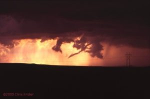
We kept driving closer to it, with our view hampered by lovely foothills — nearly mountains — as the storm produced a big, cone-shaped funnel. By all accounts, it didn’t touch the ground, though we had a pleasing optical illusion with the bottom of the cone obscured by a peak. It sure looked like a tornado!
As we passed several chasers parked by the side of the road and got through Guernsey, we proceeded uphill again to a beautiful vantage point east of the area of rotation. We were nearly alone (for a while) at this lofty spot. The storm produced a finger-shaped funnel that became a wispy rope, appearing to touch down only at the last moment. It seemed that, yes, we saw a tornado, the most ephemeral of tornadoes, backlit in orange as it dissipated in a sinuous tendril of smoke-gray vapor.
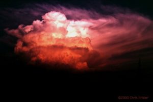
The tornadic show was over, but the light show was not. What followed was an incredible sunset of blues, greens, purples and oranges, muted by curtains of rain, waves of dust and roiling clouds, which gave the sky the feel of a rich, abstract watercolor. Paralleling the road were more trains than I’d ever seen, their headlights bright as they crept alongside the roadway, as if trying to find their way out of a mist.
After dark, we ran into the Cloud 9 Tours group at a Pizza Hut, where we could see an amazing lightning display and gusting clouds of dust outside. The group was a bit dejected at its bad view of the teeny tornado, but they would all feel a lot better the next day — they saw the big Nebraska storm.
Right now, as I write this, we’re traveling under the messy rain and corpulent gray clouds of the cold front hanging over north Texas. (Dave is driving, of course!) We saw some great lightning in north Texas last night, but it wasn’t close enough — we tried to get closer, but in our fatigued state, we just couldn’t drive any farther after leaving Hastings, Nebraska, yesterday morning. We have slim hopes of storms in west Texas on Saturday. Then Dave joins Cloud 9 Sunday, while I go my own way.
A little after I wrote this, we decided to broach the line of storms on the cold front in north Texas and caught the whole arc of a brilliant double rainbow, as well as some milky mammatus clouds against a battleship-gray sky. Sometimes the little moments are as wonderful as the big ones!
NORMAN, Oklahoma … May 22, 2000, 1:44 a.m. central time
I’ll make this a short bulletin, since there’s not much to report. Chaser angst has set in big-time.
Sunny days are dreadful when all you want is storms. But it’s amazing how weak dynamics will produce storms anyway. The magical Texas panhandle has kicked off storms for two nights running. Saturday night Dave and I caught some fabulous lightning in the panhandle and western Oklahoma; I have yet to see if any of it showed up on film, as I haven’t had my slides developed yet. I’m not terribly hopeful, as I’m still learning my way around both lightning photography and my new camera. But the experience was satisfying.
Tonight, the storms came to us, in Oklahoma City, though the line was a brief and unimpressive distraction.
I expect to set out for Kansas tomorrow.
ALTUS, Oklahoma … Friday, May 26, 2000
Many chases and, before you ask, no new tornadoes.
I know, it’s not really about the tornadoes. But more and more, I get irritated if there are tornadoes and I don’t see them.
Monday, I was going to head to Goodland, Kansas, to start work on an article about the latest severe-weather research project. Instead, kicking around on a hot afternoon in the Guest Inn parking lot after a local photo lab in Norman, Oklahoma, scratched — nay, scraped! — some of my precious slides during developing — an impromptu chase developed. A look at data revealed a bullseye of potential developing over northeast Oklahoma. The caravan: George Kourounis, with Dave as a passenger (Cloud 9 Tours wasn’t chasing that day, so Dave, who had joined the tours, rode with George); Richard Bedard, author of “In the Shadow of the Tornado” (nice book!); and myself.
 We saw the storm from when it was a pup, a little towering cumulus. It exploded and soon became a big bad dog — isolated. Huge. Multiple overshooting tops. But it was SCREAMING southeast, way ahead of us. It zoomed into Arkansas (Richard left us in mid-chase because of the hopelessness of the pursuit), and we had to listen to hail reports and spotter-reported tornado warning(s) as we tried to pursue it. We ended up in Arkansas, just east of Fort Smith, with a photogenic bomb that formed on its backside — very pretty, though it croaked at sunset. We met David O. Stillings, the Lightning Stalker (that’s just how he introduces himself, too, at rat-a-tat speed) and Jason Persoff, both Florida chasers traveling with a Pioneer Productions TV crew, as well as a couple of Arkansas chasers — Jason Politte and Scott Blair. We’re all part of a strange, little mobile community that keeps meeting on the grassy banks of farm roads in the middle of nowhere.
The distant chase meant, after yet another meal at Pizza Hut, that I had to make strides toward Goodland, on the western edge of Kansas. To make a long story shorter, after a stay in Salina, Kansas, that night (or morning, actually), I got to Goodland the next afternoon and did some of my reporting Wednesday before heading south to try to catch some potential storms in Oklahoma and Texas. While checking data at a truck stop in Cimarron, Kansas, I noticed a couple of puffs of white on the satellite image in the most promising area. But the time I’d gone outside and filled up the tank, the puffs of white were aggressively building storms, in sight to my south, on the border of the Oklahoma and Texas panhandles. I ended up punching the core of one, but it was just a huge HP (high-precipitation) mess. Got a fantastic rainbow and lovely sunset near a windmill on the west side, however, as well as some pretty lightning while I headed for Woodward, Oklahoma, where I spent the night.
Thursday was a romp through the Oklahoma and Texas panhandles — I was supposed to meet Cheryl Chang and entourage in Guymon, Oklahoma, but when I got there and called her she was a zillion miles away in Amarillo. Hmmm. I ended up on my own, getting into a mean storm in eastern New Mexico; I found the storm’s base at the heart of its curtains of rain just as the storm began to collapse. My car was caught in the gust-out as dirt and vegetation blew across the road in front of me at what I’m guessing was, at times, 50 mph wind. As the car is buffeted while I speed south, you can hear me babbling on my videotape, “Uh oh. I’m in trouble. I might have to stop and turn my car into the wind here …” I was both dreading and hoping that it would produce a tornado right behind me before it completely blew itself apart.
Trapped in the road network from hell, I made it out of the maze of dirt roads (thank you, GPS!) and back into the gorgeous and desolate hills of the western Texas panhandle, following and penetrating the storms again. I got in the clear and saw a decent base on the storm I’d been through, but few roads and the need for fuel prompted a detour in Amarillo.
I heard the tornado warning too late to get there.
Twenty minutes can make all the difference when it’s nearly 9 p.m. Daylight is almost gone. And the spotter-reported tornado, southwest of Amarillo near Dawn, Texas, on a completely different storm, was over by the time I intercepted the storm. By then, the sky was pitch-black anyway, notwithstanding the strobes of lightning.
May 25, 2000
Then it was north to Spearman, Texas, to meet Cheryl and her gang at the NursaNickel Motel (really). On the way, I speedboated my way through street flooding in Panhandle — where the bank had its sprinklers running. Duh!
Today was the ultimate in frustration. I don’t claim to be the best forecaster in the world, but I was thinking we should start in an area near Lawton, Oklahoma. We might have caught a long-lived tornadic storm reported later in that region — but we didn’t go that way.
May 26, 2000, near Altus, OK
From there it turned into agony as we heard unreachable tornado warnings. We ended the day looking at a gorgeous, small, almost stationary cell near Altus that had apparently formed behind the tornadic storm well to its north. Its scalloped anvil glowed orange as it formed a bell-shaped updraft base — the shape was suggestive of rotation, but it simply lacked the power to complete the act. It was a lovely confection but a less than satisfying consolation prize.
So, more exhaustion, and another chase day tomorrow. My expectations are lower for tomorrow, so my disappointment should be lessened too.
SIDNEY, Nebraska … May 31, 2000
The day after my last bulletin … Saturday, May 27 … our group was heading south of Altus, Oklahoma, to play a promising area south of Wichita Falls, Texas. It was early afternoon, when you don’t expect severe storms yet, but towers were going up already. We were shocked to hear the tornado warning for a storm near Archer City, Texas, around 1:30 p.m.! We missed two slender, landspout-type tornadoes before we got to the storm, but managed to get south of the cell in time to see a beautiful front-lit, long, white funnel extend from its flank — it lasted for a few minutes, and its rotation was obvious. (I do not believe it was a tornado, as some chasers have said, as we never saw it touch the ground, but it was very persistent.) It was about 2:30 p.m. To get ahead of the storm, we passed dangerously close to the swirling clouds, looking around constantly for signs of trouble as we drove under the edge of the storm, flirting with the hail core. A pickup truck with a bunch of happy, clueless people in the back were heading right into the core. Cheryl rolled down the window and yelled at them to turn around.
A big wall cloud looked like it was getting its act together, and then the storm went linear, forming a shelf cloud and losing its tornadic qualities.
We decided to punch the core of the storm to chase a couple of cells forming to its north. Fortunately, the precipitation area was small, and so was the hail where we bored through the line. Yet other chasers saw grapefruit-size hail out of the storm! But the other storms didn’t have the power of the one we’d seen, and we were too far from the developing storms that produced tornadoes east of Dallas. Unlike a usual storm-chasing day, we found ourselves done with the chase at a normal dinnertime and ate with a group of other chasers. Then we went our separate ways.
Cheryl Chang and I visited with Steve Sponsler and Susan Jensen at their hotel in Wichita Falls briefly, then headed north to Lawton, where we were lucky to get a hotel room on the holiday weekend. The next day, Cheryl and I kicked around Oklahoma City, I dropped her at the airport around 5, and then I headed to Garden City, Kansas, to meet with Steve’s group, which included Nick Nicholson, Susan, John Moore and daughter Beth, and Greg Brenneman.
May 29, 2000, Nebraska
We ran into Matt Crowther and Betsy Abrams and decided that the storm wasn’t tornadic anymore and headed north to “better” atmospheric territory, but all we saw was Carhenge north of Alliance, Nebraska. Later a piece of the storm we abandoned broke off and reportedly produced a weak and dusty tornado. Such is life. We did see the most fantastic mammatus of my life on the way back to Sidney, Nebraska — a field of large, scalloped clouds hanging from the anvil of an otherwise unimpressive storm. The sunset cast this dramatic ceiling of clouds in golden light and architectural shadows. Gorgeous!
Yesterday was a big bustola as we went into eastern Wyoming and northeast Colorado. Early in the day, that area had looked good, but as the day went on, good old unreachable Iowa clearly seemed the place to be. Too bad it was too far away. Anyway, it was fun, as our already unwieldy entourage met up with several other storm chasers and loafed in a truck stop and along the side of a gravel road, hoping for a miracle, before heading back to Sidney, Nebraska, for dinner at Dude’s Steak House.
Today looks iffy. I will have to head back to Goodland, Kansas, to do some more reporting for an article for Florida Today, so I’ll do that sometime today. But if I can squeeze in a chase, I will.
GOODLAND, Kansas … June 1, 2000
The storm I saw today in eastern Colorado (thanks to Cheryl Chang for data) turned into a dust machine! It was the opposite of a vacuum cleaner. It was pretty from a distance, and it hit Goodland just as I was about to take my bags into the hotel, so I filmed it with the car door partly open. Dust got in EVERYTHING … I hope my camera survives. The entire inside of the car has a coating of dust. But I got a cool thing on video … the plant “greenhouse” outside the WalMart, which had plastic sheeting on a metal frame, was trashed by the wind as I was filming it. If only I could uplink to TWC … it’s their kind of video.
Here’s a collection of bulletins from the field, written during my 1999 storm-chasing trip in the Great Plains. They are slightly edited, but they give a sense of what it’s like to live life by the sky. Dates reflect when each bulletin was written.
May 11: Motel 6 in Denton, Texas
There’s nothing like hitting the ground running, or hitting the road driving. On Saturday (May 8), Dave Lewison and I drove from Baltimore to Springfield, Missouri, in order to be in range to chase storms the next day. That was Sunday, and we drove all the way to western Oklahoma and the Texas panhandle.
There was bad visibility — the storms fired in a mean, mushy line, so it was difficult to make out any structure. With the help of Allan Rosenberg giving us hints on the phone, we got in front of one storm and got some footage of it rolling into Quanah, Texas, then went south to Crowell. There, a rain-wrapped beast (i.e., it was impossible to see what was going on inside of it) was approaching the town. When the radio issued a tornado warning for the storm, which was practically on top of us, we scooted east darn quick, as it was getting dark and we couldn’t see what was happening. It was a radar-indicated warning anyway, which means there probably wasn’t an actual tornado involved.
The next day, after lunch with a couple of chaser pals, we headed to northern Oklahoma under partly sunny skies to see if storms would fire. On the way north on I-35, we passed a small portion of the F5 tornado damage in Moore, Oklahoma. It was staggering. Photographs can’t do it justice. It’s as if the neighborhood went through a blender. It’s humbling just to see it.
We reached our target town in northern Oklahoma. After much hanging around at a convenience store and the local Sonic drive-in eatery, we were about to give up … but still, we kept an eye on some aspiring cumulus to our north. And lo and behold, one of them started to look good — a firm tower was going up, so we turned north and began to pursue it. It grew a large anvil and kept building at the back of the storm, getting bigger and bigger. No rotation was evident, but it was a beauty, and as it sprouted a big anvil, the light from the setting sun hit its crown. We finally got close to it, crossing the border into Kansas, but could see no wall cloud (from which a tornado might form). Still, we watched it for quite a while as it got dark. It produced a great lightning show and then started throwing out quarter-sized hail. PLUNK! PLUNK! Worried about getting major dents, we booked out east ahead of it. Once we got far enough, we were able to park the car on a deserted farm road and take some lightning video and time-exposure photographs. Spectacular anvil crawlers were lighting up the sky, like iridescent spiders. The drawback: We got back to the hotel in Norman, Oklahoma, at 3 a.m.
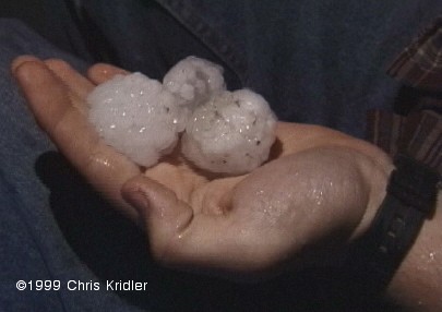
Hail, May 14, 1999
Hail in the road, May 14, 1999
Still, I’m happy to be out here on the open road, staring at the sky, living for the moment. And I have hopes for better storms later.
May 18: Super 8 hotel in Norman, Oklahoma
I know it’s a long time between updates, but I’ve been absolutely crazed. This is the first good down day I’ve had in ages. I’m actually grateful for blue skies today so that I can deal with laundry, bills, etc. I even had a SALAD with lunch today! Actual green leaves! You would not believe how much junk and diner food one consumes on the storm-chaser diet.
So … after a day of driving back to Norman last Wednesday, getting film developed, etc., I had a fun evening watching other chasers’ storm video, including Jim Leonard’s amazing footage of one of the May 3 tornadoes. It wasn’t the one that hit Oklahoma City, though he did see that storm at its genesis and got footage of it producing one tornado early on. But he jumped to another storm and captured a spectacular, large, white tornado moving through a field, with the texture of cotton candy.
Thursday, a three-person BBC crew hooked up with Dave and me. The BBC has lots of crews out here, following around chasers, scientists and so on. That day, we drove up into Kansas to get into position for the next day, because western Kansas/southwestern Nebraska looked good. Friday morning, the forecast wasn’t as obvious, as Texas looked to have potential too. But we pored over the data and decided it would have to be southwestern Nebraska, where a small clearing in the cloud cover would allow for daytime heating and thus provide fuel for storms.
It was a relief to get out of the clouds that were over Salina, Kansas, and into the clear. We paused at a truck stop to get more data and saw that a tornado watch had been issued for our target. That got us a little more excited, so we blasted northwest over some lovely, empty farm roads and into the area where storms were already starting to fire. We got close to one that had a tornado warning on it, but no apparent tornado — it quickly lost its organization and turned into a gust front, or rather a dust front, as huge, billowing clouds of red dirt blew at us. We tried to get into position to chase something better, but the storms were turning into a furious line and we ended up getting hammered by hard rain and small hail.
We stopped at a gas station to let the worst of it pass and saw the VORTEX research team buzz by. As the storm cruised past, the light was incredible, and a rainbow hovered before us as we sped off toward another tornado warning. No luck there, but the storms were a sight to see, sending lightning across the sky and glowering on the horizon.
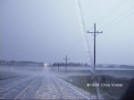
Then, things got nasty. We decided to head for a town in Kansas to get into position for the next day and thought it would be a relatively easy drive. No such luck. The line of storms kept developing to our southwest, continuously pounding us, as we drove east, with fiercely intense rain and hail for, literally, hours. We briefly turned around a couple of times to avoid the big hail. When we resumed our course, we found so much hail on the road, it was like driving on gravel. It was even producing a “hail fog.” We stopped for a second and Dave picked up a few of the 1.5″ stones — and saw bigger stones by the side of the road.
In Stockton, Kansas, under yet another severe thunderstorm warning, we gave up and found an old motel. We got soaked running the six feet to the door to register. I felt bad for the BBC crew, who’d been following in their own van — I knew how exhausted *I* was from the drive, and they had never seen rain like that before.
The next day, Saturday, the forecast looked a lot more unlikely than it had the day before. The cloud cover, or “convective debris,” as the Storm Prediction Center so charmingly called it, was inhibiting the all-important daytime heating. We drove west for a ways, looked at the data again, and decided that any storms that might pop up would be garbage anyway. So we parted ways, with the BBC heading off to join another chaser and Dave and I beginning the drive back toward Norman, so that he could join Cloud 9 Tours on Sunday. Later, we found out that a tornado had occurred in the Stockton area, where we’d spent the night!
Sunday morning in Kansas, when Dave knocked on my door, it was clear that we were looking at big potential for storms, as there was lots of moisture in the air, it was sunny, and a cold front, low pressure and a diffuse dryline were setting up. He was willing to put off the tour a day — since the group wouldn’t be chasing, just having its orientation party — so we headed toward central Kansas. In Great Bend, a convenience-store clerk was nice enough to let us use the phone line to check the data. We picked a target slightly east of the center of the state, where the dewpoints and convective potential were nearly off the scale.
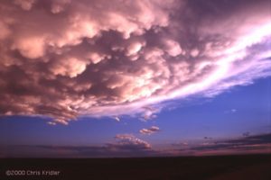
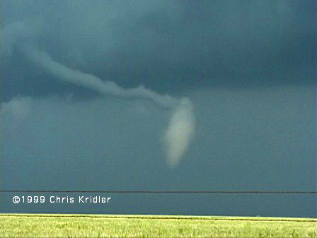
We fueled up in McPherson under “turkey towers,” skinny cloud towers that seemed to bode well for storm towers later on. The cap, or layer of warm air, hadn’t been broken yet, but the clouds were a good sign. We got a little east of the main area of convection, and then the sky began to explode. A few of the towers quickly began to build, breaking the cap and then shooting upward and gaining mass and strength. Their sheared appearance was a good sign of rotation. We kept up with the biggest one. Then I saw something suspicious — it looked like a funnel was angling out of the base of the storm. It took me a couple of minutes to convince Dave as we sped along, and finally, it was clear — a quick, distant, needle-like tornado, which caused some damage in Enterprise, Kansas.

May 16, 1999, mammatus
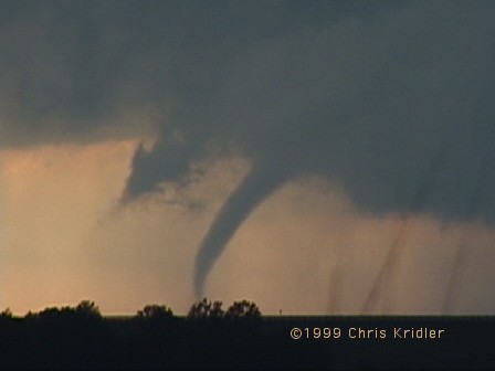
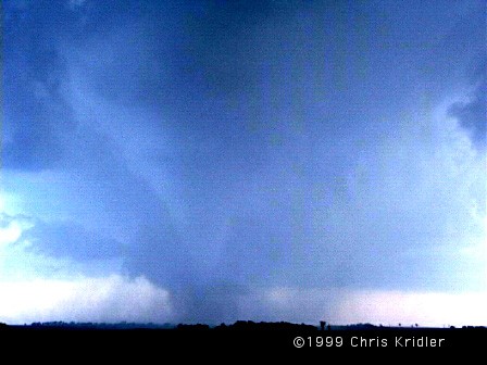
May 16, 1999, tornado
May 16, 1999, tornado
May 16, 1999, tornado
Again, Dave and I dropped south, driving through the town where the sirens were wailing, and pulled off on another farm road, keeping an eye on what looked like two areas of circulation. Then — one produced. It was a beautifully backlit tornado, and we managed to get a couple of minutes of video as it set down and then roped out. (No still photos; I was too distracted at the time! Plus it was a little distant; thank goodness for zoom lenses.)
The sun was setting fast, and the storms were aglow, but the ones we’d been chasing were losing their power. It was time to get Dave back to Norman. So we headed toward the interstate and, to avoid driving through another several hours of pounding rain, stopped in Wichita to get some food. We unwittingly stopped at a coffee shop in a flood-prone area. As the rain poured and blew in hurricane-like gusts, sky-ripping CGs (cloud-to-ground lightning strokes) were zapping the city, hitting nearby poles and disrupting the electricity more than once. As the torrent waned, the waitress suggested a route to avoid the flooding. But the alternate route was almost as bad. We managed to get through, but on a parallel street, cars were halfway submerged, their headlights barely showing in the water. And the huge drainage canal that runs parallel to I-35 was gushing, halfway full.
The worst of it was over for us, however. We made it back — another late night — and Dave joined the tour. Yesterday, I chased by myself but ended up seeing very little of the line of storms that went through Texas. They weren’t that exciting anyway, which was small comfort for wasting a day and using up a whole tank of gas when I could have been catching up on my sleep.
And today, at last, I’m doing laundry and errands and maybe even going for a swim in the pool. I also have to try to forecast when the next chase day will be. The pattern is quiet right now.
May 23: Motel 6, Hays, Kansas
This trip is going by so quickly, it’s hard to remember what day is what. But May 20, Friday, is an easy one to remember.
I was chasing on my own. I headed from Norman, Oklahoma, to Shamrock, Texas, to check data at a truck stop, where I ran into some old friends from Cloud 9 Tours. After a nice reunion and another run-in with another BBC crew that was following the group (they’re EVERYWHERE!), I decided to head west on I-40 a bit, where many elements were in place for severe storms. Among them, the dryline was pushing into the Texas panhandle, and a small line of cumulus clouds was appearing on the satellite image, so it seemed like a good place to start.
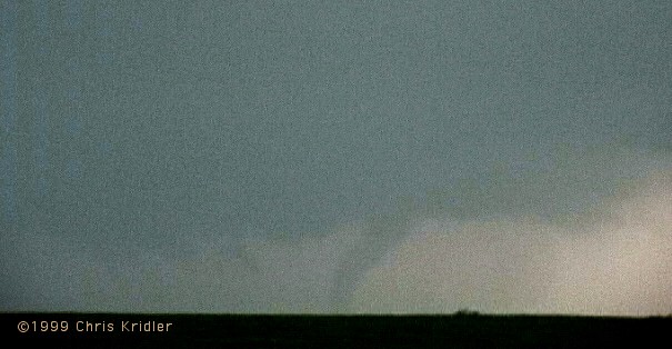
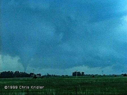
May 20, 1999, tornado
May 20, 1999, tornado
Then the storm starting cranking, showering me with small hail and picking up speed — as well as moving south, which is very unusual and indicated that this storm had potential to produce something more than rain. I met Tim Marshall, a well-known chaser who runs a magazine called Storm Track, and then, all of a sudden, there were about a HUNDRED chasers on this storm! It was unbelievable. Lots of geeky cars bristling with antennas, leap-frogging as they pulled off the road and pulled back on.
Just north of the Interstate, those of us who had waited to flee the storm were rewarded with an up-close-and-personal look at a strange white tornado to our east that touched down briefly in a field and then stretched out weirdly as it dissipated. It was beautiful. As the clouds churned overhead, I decided to head south again to avoid having a gustnado (a little spin-up; I had already seen one) land on my head.
South of the interstate, I saw two more well-developed funnels form, though they didn’t touch down that I saw. At one point, it really looked like the storm was getting its act together to produce a big tornado, but it did not. Still, more tornadoes were reported on it; though I was on the storm the whole time, I didn’t see those. It was a huge storm, so it’s conceivable that something formed out of my sight.
I counted myself lucky, because I wasn’t stuck in the hail core. The Cloud 9 group, which had headed south when I went west, ended up having to approach the storm through the hail. Though the group saw the tornado, a couple of the vans were dented up and lost windshields to 5″ hail! That’s HUGE. We’re talking grapefruits. I wish I had seen the hail, but I’m glad my car didn’t have to experience it.
I had a down day on May 21 and took the opportunity to hike in beautiful Palo Duro Canyon, just southeast of Amarillo. I took lots of photos of wildflowers and blooming cacti, and tried to capture (on film) a keen green lizard. Then I drove to Garden City, Kansas, to get in position for yesterday’s chase.
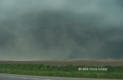
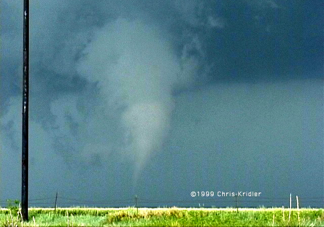
May 22, 1999, “Dust Bowl” storm
I chased, or was chased, for a couple of hours and stopped to take photos of the amazing shelf cloud the storm developed. It took on a fantastic layered appearance as it crunched south. I parked by a lake to get a couple of photos and told the people fishing that there was a severe thunderstorm warning. All left, but then a couple of anglers arrived and didn’t CARE that there was a warning. “Oh, I’ve seen worse,” one old guy said as lightning struck nearby. DUH! Fishing poles. Flat lake. Lightning. You do the math.
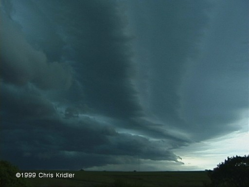
May 22, 1999, shelf cloud
Today, I probably won’t chase. The prospects are slim and distant (in New Mexico). Maybe I can finally get in that movie — what’s it called — you know, the one with the spaceships …
May 27: Motel 6 (yet another one!), Fort Worth, Texas
Well, the trip is more than two-thirds over, and I’ve put more than 8,500 miles on the car. I’m truly sick of diner food. But the wonderful storms keep on coming.
I drove in a big circle on May 24 from Amarillo, Texas, to Roswell, New Mexico, and back into Texas, seeing cloud towers corkscrew and collapse all day. I should have stuck to my original forecast — closer to Roswell — because that’s where there was a tornado warning. (Plus, maybe I could have seen a UFO.) That’s OK; when I arrived at my hotel in Lubbock, I got to experience a line of severe storms that ran over the city. There was some very intense lightning (one cell-phone tower was zapped four or five times) and heavy rain. I met a few chasers from Illinois who were also at the hotel. They had never chased Great Plains storms before and were finding out that the weather out here is a very different beast.
May 25, 1999
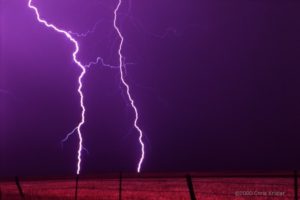
On May 26, I met up with the Illinois chasers again, and we ran into a chaser convergence at Big Spring, Texas. On hand was the Silver Lining Tours group, as well as Dr. Howie Bluestein of the University of Oklahoma and his mobile radar. I introduced myself to him since I’d once interviewed him for an article. After getting data at Midland, Texas, and running into more chasers, we headed west to keep an eye on a cell coming out of Carlsbad, New Mexico. Few road choices and the momentary allure of another cell meant we weren’t close to it when a “tornado on the ground” warning was issued. We came back to it from the east. Under a nice wall cloud, a very suspicious-looking lowering formed. I reviewed my video, and I think it was possibly a tornado, but I can’t say for sure. We couldn’t stick around long enough to examine it or get closer because, for one, it was becoming rain-wrapped and thus invisible, and two, the storm was beginning to form a vicious, hail-filled gust front that was already looming over our heads, cutting into the sky like a giant black spaceship (think “Independence Day”). We turned tail and zoomed east at warp speed, but not before we spotted Dr. Bluestein’s mobile radar vehicle roaring west toward the heart of the storm — perhaps toward the gap between the lowering and the hail core. We ended up in Crane, Texas, where we waited out the front and saw some truly spectacular lightning, the best I’ve seen this year.
Today was an off-day. I met up with the BBC crew again for a wrap-up interview. The “bad” weather should start again soon — I hope.
June 1: Guest Inn, Norman, Oklahoma
It’s funny how the prosaically named Norman has become a kind of second home. I know where the laundry is, I know where the post office is, I know where at least some of the restaurants are. Though they all close early — I had to go to Denny’s again tonight. You know, I’m starting to LIKE Denny’s. Egad. Tonight, the Sunshine Slam with hash browns and a side of fruit — fat banana slices, fork-repellent purple grapes and juicy red strawberries. Not bad.
May 30, 1999, Kansas. I have a better non-video pic of this too…
Yesterday, May 31, was a day of frustration, as many tornadoes were expected but only a few appeared and were seen. I didn’t see any of them, though I was definitely in the “hot zone” as far as lightning was concerned, as I was cornered by a great beast of a storm. Around sunset I intercepted the storm that had produced a couple of the tornadoes, but for all the time I watched it, it produced no more. At least one more was reported later, after dark, when I had abandoned it. The footage on The Weather Channel of the one large but short-lived tornado was very annoying!

June 1, 1999, rainbow
In pop-culture matters — well, pop culture is hard to find out here. In trying to listen to storm warnings on the radio over the past few days, I have become intimately familiar with the country music top 40. Please kill me.
I also have to have my say regarding the new “Star Wars” movie, which I saw on Friday. Here are a few points I feel compelled to make:
Jar Jar Binks: Stinks.
Queen Amidala: Bland, OK, but incapable of opening her mouth all the way when she speaks. Is it the lipstick?
The plot: Hopelessly transparent. I can’t believe they’re going to wait to “reveal” the villain.
Samuel L. Jackson: I love this guy. He has about two lines. What’s up with that?
Best scene: The pod race. Excellent intergalactic “Ben-Hur” ripoff.
Ending: Way too chipper. When in the hell is the Dark Side taking over?
Biggest absurdity: The Darth Vader virgin birth theory.
Overall: Flashy. Lacks gravity. Good moments. Basic fun. Cute Anakin. Cuter Obi-Wan. B-.
I’m sure you didn’t need that movie criticism, but aren’t you sick of reading about thunder and lightning? I haven’t posted any new photos. I’ve been too tired and driving too much. Almost 11,000 miles on the car this trip so far.
June 7, 3 a.m.: Home, Glen Burnie, Maryland
What would possess two storm chasers to delay their trip to the East Coast and drive 27 hours straight from the Nebraska-South Dakota border? A “high risk” chase day, that’s what.
It had been a frustrating week. Wednesday, June 2, I chased on what was supposed to be a good day in the Texas panhandle but turned out to be a line of severe storms wrapped in rain. There was a tornado I didn’t see, many miles south of me, that was apparently visible for about 30 seconds to the VORTEX research team. I could see almost nothing in the storm I got caught in, except I got hurricane-like video of trees blowing in the gale. And a gorgeous sunset and rainbow followed. June 3 in southern Kansas and the Texas panhandle was a super-bust — in fact, the only “dry bust” — i.e. no decent storms at all — that I had all month. Friday, June 4, I ended up hooking up with an entertaining caravan of fellow chasers from Wisconsin, Colorado and New Jersey and chasing storms in western Nebraska. The storms didn’t look that great, so we gave up on them. Of course, the ever-persistent VORTEX research team managed to get a couple of tornadoes just after dark in an area with virtually no roads. Most of us were puzzled as to how, but I think it has something to do with the whole idea of no results, no government funding. Or perhaps their cars have wings.
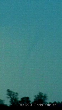
Tornado, June 5, 1999
Tornado, June 5, 1999
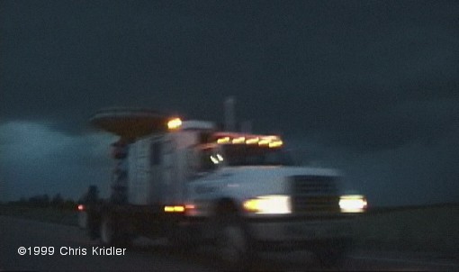
Mobile Doppler, June 5, 1999
We left the Cloud 9 group — I had to meet up with them that morning to retrieve Dave — but ran into them again at a truck stop in southern Nebraska on I-80, along with a bunch of other chasers. This chaser convergence is not at all unusual. Sometimes it’s fun, but at other times it’s irritating or downright dangerous if too many are on a storm. At this point, we were just all figuring out where to go. Dewpoints were near 70 in eastern Nebraska, which meant explosive potential should storms go up there. But there were also signs that they could initiate farther west. At the least, Dave and I knew we had to go north into the better air, and where we could intercept northern-moving storms. Near the area where we thought we might turn west, we spotted an area of cloud towers trying to form to the north. Soon one of them became a quickly sprouting bomb, and we began pursuit. It must have been moving northward at a very fast pace, because we could never quite catch it as we blasted into northern Nebraska — and then it died.
We were at a loss and without information on where other storms might be firing, though we saw another anvil from a storm to our southwest and were tempted to go after it. At least we would be intercepting it FROM the north. Tim Samaras, a fellow chaser with a satellite dish, confirmed what we saw — the cell we were seeing was the only one for miles around, it was big, and it had potential. When a storm is alone in such a juicy environment, it tends to go crazy. We went west to intercept.
As we got near it, we took a south road and paralleled it for a while. It had a beautiful structure, a hard convective tower that showed it meant business, and it seemed to be trying to organize a wall cloud (from which a tornado might form). But we had to get closer to be sure, so it was back north and then west through the town of Bassett. The storm was moving north at an amazing rate, possibly 50 miles per hour. It was catching up to us very quickly. We stopped just west of the town as the base of the storm approached the road and focused on a developing mesocyclone, or area of rotation, within the storm. It took us a moment to realize that a much more impressive meso was developing practically over our heads — a large, clearly rotating area, and we were under the northeastern edge of it. On the opposite side of the meso, we suddenly saw it — a funnel forming rapidly in the rain. It touched down — tornado! — and moved out of the rain to the east and north toward the town, kicking up debris as it went. It had a healthy condensation funnel and was clearly chowing down on the Nebraska earth. After a minute or two it began to weaken and rope out, and as the meso was now over our heads, we booked east. Dave got amazing video of the top of the now-skinny funnel protruding from the storm almost directly over the car, which I was driving, while the base of the tornado was still kicking up dust south of us.
Once we got out of the danger zone, I noticed a big new meso just to our north — the storm was moving northward, and fast. We were going to head north but changed our minds and headed east, just in time to catch an even bigger tornado north of the road. It, too, didn’t last more than a few minutes, but it was impressive (even if Dr. Howie Bluestein, mentioned in a previous bulletin, parked on the wrong side of the road between us and the tornado with his research vehicle while we were filming). I haven’t looked at damage reports yet, but I don’t think the twister hit any houses (I heard it struck some chickens, however!). And unless a tornado hits a well-built structure, it’s difficult to characterize its strength. However, Jim Leonard, who saw it too and has been chasing for more than 25 years, said it could have been as strong as an F3.
We tried to play catch-up with the storm and managed to see more signs of rotation. We even cut through the edge of the rain core to get ahead of it. But we saw no more tornadic action. The sun had set, the light was failing, and the storm was hurtling north at probably 50 miles per hour. Helicopter, anyone? We ran into Cloud 9 and a couple of other chasers (there may have been 20 or more cars on the storm at any one time) and compared notes, then marveled as the cell was lit up by lightning while stars shown above it. The vacation ended not with a whimper, but with a bang. And with the aforementioned 27-hour trip back, which began immediately after the chase. Remind me not to do that again.
Summing up the trip: 6 (maybe 7) tornadoes, a few funnels, an amazing month of storms. Lots of Texas dust and 12,000+ miles on the car. 14 hours of video. An as-yet unseen cellular phone bill, but I may need resuscitation after I get it. And about 4 hours of sleep in the past two days.