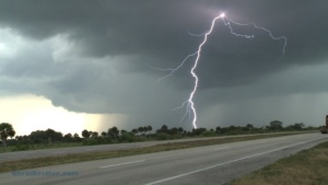
There’s nothing like eating your continental hotel breakfast of generic fruit loops and hard-boiled egg while hearing the morning “crapvection” spitting rain all over your hopes for the day. Not that I am entirely without hope, or I’d be at home, given that essentially all storm-chasing is about gambling time and gas money against a few moments of reward. But this morning, what it comes down to is that this big shield of clouds and rain is going to have to get out of the way in order for sunshine – and thus heat and destabilization – to occur to fuel severe storms later. How all that will play out is up to Mother Nature. In addition, there are multiple potential target areas. Northern Kansas? Oklahoma-Kansas border? Mars? Rather than rush out to chase the rain, I’ll do a little more analysis before I give up my wi-fi.

Lightning sparks near Rushville, Nebraska, on May 9, 2011. Photo by Chris Kridler, chriskridler.com, skydiary.com
I am disturbed and amazed at the wave of tornado onslaughts … and now flooding, too … all in the same area. People keep asking me why I’m not there. Many chasers are seeking and finding the storms, but many tornadoes are occurring in what is referred to as “the jungle,” because of the hills and trees. In other words, visibilty is low, making it extra hard to track the storms. And of course, the people who live there can’t see them coming, either. If you are in the danger zone, leave your weather radio on. It will give you the best and fastest warning.
Much wiser storm chasers than I have said, “Live by the models, die by the models.” But one must live a little by the computer models in order to figure out when to make the (ideally) two-day drive out to Tornado Alley. I’d much prefer chasing storms in the lovely, flat, empty expanses of the Alley than in the trees and hills and populated areas where tornadoes have been wreaking havoc for the past few days. When I live as far away as I do, it becomes somewhat of an expedition to get all the gear ready, load up the car, and get the heck outta Dodge. Or to Dodge – I’ve passed through Dodge City, Kansas, almost every year of chasing, it seems. It smells like cows.
That said, I’ve ordered a rental cell modem so I can get data while mobile. It’s a long way from the days when I had to plug into a phone jack at a truck stop and sign on to the Internet that way to get data – and that was awesome. Granted, you can’t get mobile data everywhere, but it’s amazing where you can get it.
Anyway, I’m starting to get everything ready. I’m working my last few days as a full-time newspaper reporter this week, as I begin a freelance career. And I’m trying to find a missing camera battery. You haven’t seen it, have you?

A turkey tower (ambitious cloud) even sports a few mammatus as it moves east with a boundary in Rockledge, Florida, on April 12, 2011. Photo by Chris Kridler, ChrisKridler.com
I drove slightly out of my way this evening to get about 10 raindrops on my windshield as a front pushed through the area. I was hoping for a little more excitement, especially after I saw some, you know, clouds. I talked with my friend Steve Sponsler, who writes a great forecasting blog that focuses on Florida. He feels his forecast verified, because, after all, there was rain.
This time of year, it’s easy for storm chasers to obsess about the weather. I haven’t been, because I’ve been busy trying to finish up things at my job so I can start working for myself. But the obsession is about to begin, since storm chasing is just a few weeks away. I have a lot to do in terms of getting gear in order, and just getting in the mode of daily forecasting, too.
Well, tonight’s “chase” was rewarded at home, when this ambitious little turkey tower, complete with a few mammatus, pushed east overhead at sunset. It wasn’t powerful, but it was pretty.
Here’s a collection of bulletins from the field, written during my 2000 storm-chasing trip in the Great Plains. They are slightly edited. Dates reflect when each bulletin was written.
JUNCTION CITY, Kansas … May 10, 2000
Chasing storms is a bit like playing chess with the sky when all you know is checkers. The sky, unpredictable and complicated, always wins.
There hasn’t been much to chase so far. I set out Saturday from Florida for parts west — a 15-hour drive that put me in Monroe, Louisiana, for the night. The highlight was entering Mobile, Alabama, over an expanse of water, on a long, curving road at twilight. The sky was deepening into dark, and the highway was punctuated with street lamps, strung out before me like beads on a necklace. The low point was a psycho trucker who was harassing me by rushing up to get on my bumper, passing me, slowing to a crawl, waiting until I passed him, and then beeping at me. This happened several times until I got off the highway and took a little nap at a rest stop. I needed it anyway, as sleep-deprived as I was.
The second day’s drive … only eight hours … got me to Norman, Oklahoma. The next morning, after seeing some of the old faces from Cloud 9 Tours, Dave Lewison and I set out. We drove around in circles for hours and hours, trying to play a warm, moist area ahead of the cold front in central Oklahoma. Instead, a few storms broke out behind the front near nightfall, but considering the distance we had traveled and their relative wimpiness, they didn’t seem worth lingering over. We saw a few flashes of lightning in the storms, north of Oklahoma City, as we set off for Lubbock, Texas, where I had to do some interviews for my paper the next morning. We arrived just before 4 a.m. More sleep deprivation!
At Texas Tech, we got to see the sensor-studded building that researchers rotate to face into the wind. We talked to some knowledgeable folks about the latest in storm shelters. We also saw a few dust devils in a field outside town. Dave “punched the core” of one — running into it, that is. He was brushing away dust all day afterward. This is what storm chasers do for off-day excitement.
Today was a gruelling drive in anticipation of marginal storms that never showed up. We realized that would be the case by mid-afternoon but wanted to get into position for tomorrow. The problem is, tomorrow’s chances are way the heck east — Iowa, Minnesota, even Wisconsin — and I don’t know if we can make it from here, near Manhattan, Kansas. So we’ll have to decide after looking at data in the morning.
At least it’s good to be roaming the Plains again. We’ve been through one small town after another, dusty monuments to perserverance that fall apart a little more every year as the wind howls across the flat, desolate and strangely lovely land. There was the historic windmill park in southwest Oklahoma… the Kinsley, Kansas, sign marking the “Midway U.S.A.” point between New York and San Francisco … a sign for “Shotgun Dave’s Viking Barbecue” … a little Kansas carnival … the faux dinosaur that sits atop a hill in the northern Texas panhandle … long trains that snake through the hills and over the flats … a water tower in central Oklahoma that looks like a peach (but not like the famous butt-shaped peach tower of Gaffney, S.C. — thank goodness).
We shot some pictures today of a burnt orange sun setting behind a pumping oil well. It was a cliche, but a beautiful cliche.
Tomorrow … who knows?
SALINA, Kansas… May 15, 2000
We’ve been driving so much, I’ve hardly had time to write a thing. But here we are, in Salina, Kansas, on the eve of another chase day.
Last Thursday, Dave and I targeted northeast Iowa. Low pressure was moving into the area, which would cause the surface winds to come from the south or southeast, while upper-level winds were streaming in from the west. The result: shear in the atmosphere, meaning if a storm went up — and it was likely where the warm and cold fronts met — it would probably rotate.
Dave and I found ourselves in an area with a 74-degree dewpoint and promising cumulus clouds that were starting to bubble up and bump against the warm layer of air known as the cap. One area seemed particularly promising, as the towers became hard and aggressive there before collapsing. They got bigger as time went on. It seemed that any moment one might burst through. We sat on a dusty farm road west of Grundy Center and waited, with phone calls to Steve Sponsler and Cheryl Chang back in Florida confirming that we were in the right place. About this time, California chaser Mark Aubin met up with us.
Then the beast exploded.
This is the storm that would produce a damaging tornado in Dunkerton. The truth is, it was a tornado machine. As we pursued the rapidly expanding cell, heading north to catch up with it, we saw it developing a succession of rotating wall clouds and kicking up dust. Unfortunately, we missed the first two powerful tornadoes as we found ourselves stuck in the town of Waterloo. Navigating around it cost us valuable time and position. We had no idea a couple of giant tornadoes (as seen on The Weather Channel) were chewing through an area well north of us. The chasers who saw those tornadoes punched into the storm from the north.
Our efforts were not in vain, however. We navigated a series of gravel farm roads to keep up with the beast, which had several mesos — mesocyclones or areas of rotation — at once. While we watched the storm, Dave watched it on his tiny TV too — a crazy man in a helicopter was flying around the supercell, filming it for a local television station. The first obvious tornado that we saw was backlit by lightning and produced a bowl of dust under the meso. It also produced a fast, white satellite funnel that orbited around the main funnel — one of the most amazing things I’ve seen. It was a multiple-vortex monster. The storm produced another tornado near the multiple-vortex funnel, then another one in a field just to the east … and very near us.
It was getting dark at this time. We thought we’d attack the western portion of the storm, where it looked promising on radar (as seen on TV!), then changed our minds and headed east to keep up with the leading edge. I got some eerie video near Manchester of some suspicious-looking clouds looming over the land, seen in brief moments, lit by lightning flashes, as tornado sirens went off. I am pretty sure they were “scud” clouds, raggedy clouds on the leading edge of the storm, though they had a funnel shape. We heard damage reports from Dunkerton and realized we’d missed some of the tornadoes, but we’d seen a storm of tremendous and humbling power.
Friday was hardly worth the drive into Illinois. Though we were in the midst of multiple warnings, we could see almost nothing because of the haze, mushy clouds and precipitation. And struggling against the heavy traffic in populated areas didn’t help either. It became a war of attrition. We were in Mattoon when the sirens went off, with a screaming south wind blowing horizontal rain at us. That suggested there might be a meso nearby, but we couldn’t see crap! We got some marble-sized hail and saw some hot lightning out of the storms, then headed back west. Frankly, I was relieved to cross the Mississippi again and spend the night in Missouri. The next day, we were back in Oklahoma.
The annual storm chaser party was Sunday in Texas, at Storm Track editor Tim Marshall’s palatial home, where we saw lots of chasers and lots of video. It was a true geekfest, and there were very few women present. I interviewed a few chasers for a Florida Today story about gear and gadgets — boy, do I feel ill-equipped now.
Now, we await what a huge trough will bring to the Plains in the next couple of days. I expect we’ll head to western Nebraska tomorrow. The skies could get really violent by Wednesday. Or not.
It’s all about the moment. An orange sunset. A green wheat field. A stroke of white lightning slicing open a midnight sky.
I have no idea what’s next. I like it that way.
FORT WORTH, Texas … I-35, en route to Abilene … May 19, 2000
There’s nothing like a really good day followed by a really bad day. The really bad day makes you forget how good the good day was. Too bad it didn’t work the other way.
No doubt many of you have seen the footage of the big tornado in Nebraska on Wednesday. And no, I wasn’t there. Dave and I teamed up with Jay Antle in Ogallala, Nebraska, and checked data on the Web that morning (May 17). We targeted an area southeast of there and ran into several other chasers at a truck stop in Elm Creek. As storms went up north/northeast of the low, we decided to play the area just southeast of the first storm, where we thought more storms would fire, in an atmosphere more conducive to tornadic supercells. But this low had other things in mind. The northernmost storm — not the southern one, as often occurs — was the one that produced the tornadoes. We still feel sick after missing it. We played the storm south of it, but it just didn’t do it. As other storms went up, none of them survived the strange dynamics.
The only comforting thing is that we ran into a lot of other chasers who also found themselves farther south. However, one, legendary chaser David Hoadley, went north in time to catch the big tornado, as we found out later. We could have caught it if we’d shot north. For us, it was a “wet bust” — we saw storms but missed the storm of the day.
Going backwards in time to May 16 — the day before — we played what seemed iffy chances for supercells in western Nebraska. We thought the action would be in extreme western Nebraska or even eastern Wyoming, especially after checking data and running into chasers Keith Brown and David Fogel (again in Ogallala). As we zoomed west, it became clear that this was going to be a major chaser convergence. Translated: A circus of idiot drivers. Now, obviously, I don’t think all chasers are irresponsible, but there are definitely chasers who are giving the rest of us a bad name. They are also becoming incredibly ostentatious, with loads of silly equipment on their roofs, including (in my opinion) useless marine radar units. What, are they going boating in their Ford Expeditions?
We saw a big anvil from a massive storm as we neared the state border, so we took the plunge into Wyoming (a new state for me). Not much good structure was evident, but as soon as we got close enough, we could see what appeared to be two wall clouds hanging from its base. This storm had potential after all.
We kept driving closer to it, with our view hampered by lovely foothills — nearly mountains — as the storm produced a big, cone-shaped funnel. By all accounts, it didn’t touch the ground, though we had a pleasing optical illusion with the bottom of the cone obscured by a peak. It sure looked like a tornado!
As we passed several chasers parked by the side of the road and got through Guernsey, we proceeded uphill again to a beautiful vantage point east of the area of rotation. We were nearly alone (for a while) at this lofty spot. The storm produced a finger-shaped funnel that became a wispy rope, appearing to touch down only at the last moment. It seemed that, yes, we saw a tornado, the most ephemeral of tornadoes, backlit in orange as it dissipated in a sinuous tendril of smoke-gray vapor.
The tornadic show was over, but the light show was not. What followed was an incredible sunset of blues, greens, purples and oranges, muted by curtains of rain, waves of dust and roiling clouds, which gave the sky the feel of a rich, abstract watercolor. Paralleling the road were more trains than I’d ever seen, their headlights bright as they crept alongside the roadway, as if trying to find their way out of a mist.
After dark, we ran into the Cloud 9 Tours group at a Pizza Hut, where we could see an amazing lightning display and gusting clouds of dust outside. The group was a bit dejected at its bad view of the teeny tornado, but they would all feel a lot better the next day — they saw the big Nebraska storm.
Right now, as I write this, we’re traveling under the messy rain and corpulent gray clouds of the cold front hanging over north Texas. (Dave is driving, of course!) We saw some great lightning in north Texas last night, but it wasn’t close enough — we tried to get closer, but in our fatigued state, we just couldn’t drive any farther after leaving Hastings, Nebraska, yesterday morning. We have slim hopes of storms in west Texas on Saturday. Then Dave joins Cloud 9 Sunday, while I go my own way.
A little after I wrote this, we decided to broach the line of storms on the cold front in north Texas and caught the whole arc of a brilliant double rainbow, as well as some milky mammatus clouds against a battleship-gray sky. Sometimes the little moments are as wonderful as the big ones!
NORMAN, Oklahoma … May 22, 2000, 1:44 a.m. central time
I’ll make this a short bulletin, since there’s not much to report. Chaser angst has set in big-time.
Sunny days are dreadful when all you want is storms. But it’s amazing how weak dynamics will produce storms anyway. The magical Texas panhandle has kicked off storms for two nights running. Saturday night Dave and I caught some fabulous lightning in the panhandle and western Oklahoma; I have yet to see if any of it showed up on film, as I haven’t had my slides developed yet. I’m not terribly hopeful, as I’m still learning my way around both lightning photography and my new camera. But the experience was satisfying.
Tonight, the storms came to us, in Oklahoma City, though the line was a brief and unimpressive distraction.
I expect to set out for Kansas tomorrow.
ALTUS, Oklahoma … Friday, May 26, 2000
Many chases and, before you ask, no new tornadoes.
I know, it’s not really about the tornadoes. But more and more, I get irritated if there are tornadoes and I don’t see them.
Monday, I was going to head to Goodland, Kansas, to start work on an article about the latest severe-weather research project. Instead, kicking around on a hot afternoon in the Guest Inn parking lot after a local photo lab in Norman, Oklahoma, scratched — nay, scraped! — some of my precious slides during developing — an impromptu chase developed. A look at data revealed a bullseye of potential developing over northeast Oklahoma. The caravan: George Kourounis, with Dave as a passenger (Cloud 9 Tours wasn’t chasing that day, so Dave, who had joined the tours, rode with George); Richard Bedard, author of “In the Shadow of the Tornado” (nice book!); and myself.
We saw the storm from when it was a pup, a little towering cumulus. It exploded and soon became a big bad dog — isolated. Huge. Multiple overshooting tops. But it was SCREAMING southeast, way ahead of us. It zoomed into Arkansas (Richard left us in mid-chase because of the hopelessness of the pursuit), and we had to listen to hail reports and spotter-reported tornado warning(s) as we tried to pursue it. We ended up in Arkansas, just east of Fort Smith, with a photogenic bomb that formed on its backside — very pretty, though it croaked at sunset. We met David O. Stillings, the Lightning Stalker (that’s just how he introduces himself, too, at rat-a-tat speed) and Jason Persoff, both Florida chasers traveling with a Pioneer Productions TV crew, as well as a couple of Arkansas chasers — Jason Politte and Scott Blair. We’re all part of a strange, little mobile community that keeps meeting on the grassy banks of farm roads in the middle of nowhere.
The distant chase meant, after yet another meal at Pizza Hut, that I had to make strides toward Goodland, on the western edge of Kansas. To make a long story shorter, after a stay in Salina, Kansas, that night (or morning, actually), I got to Goodland the next afternoon and did some of my reporting Wednesday before heading south to try to catch some potential storms in Oklahoma and Texas. While checking data at a truck stop in Cimarron, Kansas, I noticed a couple of puffs of white on the satellite image in the most promising area. But the time I’d gone outside and filled up the tank, the puffs of white were aggressively building storms, in sight to my south, on the border of the Oklahoma and Texas panhandles. I ended up punching the core of one, but it was just a huge HP (high-precipitation) mess. Got a fantastic rainbow and lovely sunset near a windmill on the west side, however, as well as some pretty lightning while I headed for Woodward, Oklahoma, where I spent the night.
Thursday was a romp through the Oklahoma and Texas panhandles — I was supposed to meet Cheryl Chang and entourage in Guymon, Oklahoma, but when I got there and called her she was a zillion miles away in Amarillo. Hmmm. I ended up on my own, getting into a mean storm in eastern New Mexico; I found the storm’s base at the heart of its curtains of rain just as the storm began to collapse. My car was caught in the gust-out as dirt and vegetation blew across the road in front of me at what I’m guessing was, at times, 50 mph wind. As the car is buffeted while I speed south, you can hear me babbling on my videotape, “Uh oh. I’m in trouble. I might have to stop and turn my car into the wind here …” I was both dreading and hoping that it would produce a tornado right behind me before it completely blew itself apart.
Trapped in the road network from hell, I made it out of the maze of dirt roads (thank you, GPS!) and back into the gorgeous and desolate hills of the western Texas panhandle, following and penetrating the storms again. I got in the clear and saw a decent base on the storm I’d been through, but few roads and the need for fuel prompted a detour in Amarillo.
I heard the tornado warning too late to get there.
Twenty minutes can make all the difference when it’s nearly 9 p.m. Daylight is almost gone. And the spotter-reported tornado, southwest of Amarillo near Dawn, Texas, on a completely different storm, was over by the time I intercepted the storm. By then, the sky was pitch-black anyway, notwithstanding the strobes of lightning.

May 25, 2000
Then it was north to Spearman, Texas, to meet Cheryl and her gang at the NursaNickel Motel (really). On the way, I speedboated my way through street flooding in Panhandle — where the bank had its sprinklers running. Duh!
Today was the ultimate in frustration. I don’t claim to be the best forecaster in the world, but I was thinking we should start in an area near Lawton, Oklahoma. We might have caught a long-lived tornadic storm reported later in that region — but we didn’t go that way.

May 26, 2000, near Altus, OK
From there it turned into agony as we heard unreachable tornado warnings. We ended the day looking at a gorgeous, small, almost stationary cell near Altus that had apparently formed behind the tornadic storm well to its north. Its scalloped anvil glowed orange as it formed a bell-shaped updraft base — the shape was suggestive of rotation, but it simply lacked the power to complete the act. It was a lovely confection but a less than satisfying consolation prize.
So, more exhaustion, and another chase day tomorrow. My expectations are lower for tomorrow, so my disappointment should be lessened too.
SIDNEY, Nebraska … May 31, 2000
The day after my last bulletin … Saturday, May 27 … our group was heading south of Altus, Oklahoma, to play a promising area south of Wichita Falls, Texas. It was early afternoon, when you don’t expect severe storms yet, but towers were going up already. We were shocked to hear the tornado warning for a storm near Archer City, Texas, around 1:30 p.m.! We missed two slender, landspout-type tornadoes before we got to the storm, but managed to get south of the cell in time to see a beautiful front-lit, long, white funnel extend from its flank — it lasted for a few minutes, and its rotation was obvious. (I do not believe it was a tornado, as some chasers have said, as we never saw it touch the ground, but it was very persistent.) It was about 2:30 p.m. To get ahead of the storm, we passed dangerously close to the swirling clouds, looking around constantly for signs of trouble as we drove under the edge of the storm, flirting with the hail core. A pickup truck with a bunch of happy, clueless people in the back were heading right into the core. Cheryl rolled down the window and yelled at them to turn around.
A big wall cloud looked like it was getting its act together, and then the storm went linear, forming a shelf cloud and losing its tornadic qualities.
We decided to punch the core of the storm to chase a couple of cells forming to its north. Fortunately, the precipitation area was small, and so was the hail where we bored through the line. Yet other chasers saw grapefruit-size hail out of the storm! But the other storms didn’t have the power of the one we’d seen, and we were too far from the developing storms that produced tornadoes east of Dallas. Unlike a usual storm-chasing day, we found ourselves done with the chase at a normal dinnertime and ate with a group of other chasers. Then we went our separate ways.
Cheryl Chang and I visited with Steve Sponsler and Susan Jensen at their hotel in Wichita Falls briefly, then headed north to Lawton, where we were lucky to get a hotel room on the holiday weekend. The next day, Cheryl and I kicked around Oklahoma City, I dropped her at the airport around 5, and then I headed to Garden City, Kansas, to meet with Steve’s group, which included Nick Nicholson, Susan, John Moore and daughter Beth, and Greg Brenneman.

May 29, 2000, Nebraska
We ran into Matt Crowther and Betsy Abrams and decided that the storm wasn’t tornadic anymore and headed north to “better” atmospheric territory, but all we saw was Carhenge north of Alliance, Nebraska. Later a piece of the storm we abandoned broke off and reportedly produced a weak and dusty tornado. Such is life. We did see the most fantastic mammatus of my life on the way back to Sidney, Nebraska — a field of large, scalloped clouds hanging from the anvil of an otherwise unimpressive storm. The sunset cast this dramatic ceiling of clouds in golden light and architectural shadows. Gorgeous!
Yesterday was a big bustola as we went into eastern Wyoming and northeast Colorado. Early in the day, that area had looked good, but as the day went on, good old unreachable Iowa clearly seemed the place to be. Too bad it was too far away. Anyway, it was fun, as our already unwieldy entourage met up with several other storm chasers and loafed in a truck stop and along the side of a gravel road, hoping for a miracle, before heading back to Sidney, Nebraska, for dinner at Dude’s Steak House.
Today looks iffy. I will have to head back to Goodland, Kansas, to do some more reporting for an article for Florida Today, so I’ll do that sometime today. But if I can squeeze in a chase, I will.
GOODLAND, Kansas … June 1, 2000
The storm I saw today in eastern Colorado (thanks to Cheryl Chang for data) turned into a dust machine! It was the opposite of a vacuum cleaner. It was pretty from a distance, and it hit Goodland just as I was about to take my bags into the hotel, so I filmed it with the car door partly open. Dust got in EVERYTHING … I hope my camera survives. The entire inside of the car has a coating of dust. But I got a cool thing on video … the plant “greenhouse” outside the WalMart, which had plastic sheeting on a metal frame, was trashed by the wind as I was filming it. If only I could uplink to TWC … it’s their kind of video.
Here’s a collection of bulletins from the field, written during my 1999 storm-chasing trip in the Great Plains. They are slightly edited, but they give a sense of what it’s like to live life by the sky. Dates reflect when each bulletin was written.
May 11: Motel 6 in Denton, Texas
There’s nothing like hitting the ground running, or hitting the road driving. On Saturday (May 8), Dave Lewison and I drove from Baltimore to Springfield, Missouri, in order to be in range to chase storms the next day. That was Sunday, and we drove all the way to western Oklahoma and the Texas panhandle.
There was bad visibility — the storms fired in a mean, mushy line, so it was difficult to make out any structure. With the help of Allan Rosenberg giving us hints on the phone, we got in front of one storm and got some footage of it rolling into Quanah, Texas, then went south to Crowell. There, a rain-wrapped beast (i.e., it was impossible to see what was going on inside of it) was approaching the town. When the radio issued a tornado warning for the storm, which was practically on top of us, we scooted east darn quick, as it was getting dark and we couldn’t see what was happening. It was a radar-indicated warning anyway, which means there probably wasn’t an actual tornado involved.
The next day, after lunch with a couple of chaser pals, we headed to northern Oklahoma under partly sunny skies to see if storms would fire. On the way north on I-35, we passed a small portion of the F5 tornado damage in Moore, Oklahoma. It was staggering. Photographs can’t do it justice. It’s as if the neighborhood went through a blender. It’s humbling just to see it.
We reached our target town in northern Oklahoma. After much hanging around at a convenience store and the local Sonic drive-in eatery, we were about to give up … but still, we kept an eye on some aspiring cumulus to our north. And lo and behold, one of them started to look good — a firm tower was going up, so we turned north and began to pursue it. It grew a large anvil and kept building at the back of the storm, getting bigger and bigger. No rotation was evident, but it was a beauty, and as it sprouted a big anvil, the light from the setting sun hit its crown. We finally got close to it, crossing the border into Kansas, but could see no wall cloud (from which a tornado might form). Still, we watched it for quite a while as it got dark. It produced a great lightning show and then started throwing out quarter-sized hail. PLUNK! PLUNK! Worried about getting major dents, we booked out east ahead of it. Once we got far enough, we were able to park the car on a deserted farm road and take some lightning video and time-exposure photographs. Spectacular anvil crawlers were lighting up the sky, like iridescent spiders. The drawback: We got back to the hotel in Norman, Oklahoma, at 3 a.m.

Hail, May 14, 1999

Hail in the road, May 14, 1999
Still, I’m happy to be out here on the open road, staring at the sky, living for the moment. And I have hopes for better storms later.
May 18: Super 8 hotel in Norman, Oklahoma
I know it’s a long time between updates, but I’ve been absolutely crazed. This is the first good down day I’ve had in ages. I’m actually grateful for blue skies today so that I can deal with laundry, bills, etc. I even had a SALAD with lunch today! Actual green leaves! You would not believe how much junk and diner food one consumes on the storm-chaser diet.
So … after a day of driving back to Norman last Wednesday, getting film developed, etc., I had a fun evening watching other chasers’ storm video, including Jim Leonard’s amazing footage of one of the May 3 tornadoes. It wasn’t the one that hit Oklahoma City, though he did see that storm at its genesis and got footage of it producing one tornado early on. But he jumped to another storm and captured a spectacular, large, white tornado moving through a field, with the texture of cotton candy.
Thursday, a three-person BBC crew hooked up with Dave and me. The BBC has lots of crews out here, following around chasers, scientists and so on. That day, we drove up into Kansas to get into position for the next day, because western Kansas/southwestern Nebraska looked good. Friday morning, the forecast wasn’t as obvious, as Texas looked to have potential too. But we pored over the data and decided it would have to be southwestern Nebraska, where a small clearing in the cloud cover would allow for daytime heating and thus provide fuel for storms.
It was a relief to get out of the clouds that were over Salina, Kansas, and into the clear. We paused at a truck stop to get more data and saw that a tornado watch had been issued for our target. That got us a little more excited, so we blasted northwest over some lovely, empty farm roads and into the area where storms were already starting to fire. We got close to one that had a tornado warning on it, but no apparent tornado — it quickly lost its organization and turned into a gust front, or rather a dust front, as huge, billowing clouds of red dirt blew at us. We tried to get into position to chase something better, but the storms were turning into a furious line and we ended up getting hammered by hard rain and small hail.
We stopped at a gas station to let the worst of it pass and saw the VORTEX research team buzz by. As the storm cruised past, the light was incredible, and a rainbow hovered before us as we sped off toward another tornado warning. No luck there, but the storms were a sight to see, sending lightning across the sky and glowering on the horizon.
Then, things got nasty. We decided to head for a town in Kansas to get into position for the next day and thought it would be a relatively easy drive. No such luck. The line of storms kept developing to our southwest, continuously pounding us, as we drove east, with fiercely intense rain and hail for, literally, hours. We briefly turned around a couple of times to avoid the big hail. When we resumed our course, we found so much hail on the road, it was like driving on gravel. It was even producing a “hail fog.” We stopped for a second and Dave picked up a few of the 1.5″ stones — and saw bigger stones by the side of the road.
In Stockton, Kansas, under yet another severe thunderstorm warning, we gave up and found an old motel. We got soaked running the six feet to the door to register. I felt bad for the BBC crew, who’d been following in their own van — I knew how exhausted *I* was from the drive, and they had never seen rain like that before.
The next day, Saturday, the forecast looked a lot more unlikely than it had the day before. The cloud cover, or “convective debris,” as the Storm Prediction Center so charmingly called it, was inhibiting the all-important daytime heating. We drove west for a ways, looked at the data again, and decided that any storms that might pop up would be garbage anyway. So we parted ways, with the BBC heading off to join another chaser and Dave and I beginning the drive back toward Norman, so that he could join Cloud 9 Tours on Sunday. Later, we found out that a tornado had occurred in the Stockton area, where we’d spent the night!
Sunday morning in Kansas, when Dave knocked on my door, it was clear that we were looking at big potential for storms, as there was lots of moisture in the air, it was sunny, and a cold front, low pressure and a diffuse dryline were setting up. He was willing to put off the tour a day — since the group wouldn’t be chasing, just having its orientation party — so we headed toward central Kansas. In Great Bend, a convenience-store clerk was nice enough to let us use the phone line to check the data. We picked a target slightly east of the center of the state, where the dewpoints and convective potential were nearly off the scale.
We fueled up in McPherson under “turkey towers,” skinny cloud towers that seemed to bode well for storm towers later on. The cap, or layer of warm air, hadn’t been broken yet, but the clouds were a good sign. We got a little east of the main area of convection, and then the sky began to explode. A few of the towers quickly began to build, breaking the cap and then shooting upward and gaining mass and strength. Their sheared appearance was a good sign of rotation. We kept up with the biggest one. Then I saw something suspicious — it looked like a funnel was angling out of the base of the storm. It took me a couple of minutes to convince Dave as we sped along, and finally, it was clear — a quick, distant, needle-like tornado, which caused some damage in Enterprise, Kansas.

May 16, 1999, mammatus

May 16, 1999, tornado

May 16, 1999, tornado

May 16, 1999, tornado
Again, Dave and I dropped south, driving through the town where the sirens were wailing, and pulled off on another farm road, keeping an eye on what looked like two areas of circulation. Then — one produced. It was a beautifully backlit tornado, and we managed to get a couple of minutes of video as it set down and then roped out. (No still photos; I was too distracted at the time! Plus it was a little distant; thank goodness for zoom lenses.)
The sun was setting fast, and the storms were aglow, but the ones we’d been chasing were losing their power. It was time to get Dave back to Norman. So we headed toward the interstate and, to avoid driving through another several hours of pounding rain, stopped in Wichita to get some food. We unwittingly stopped at a coffee shop in a flood-prone area. As the rain poured and blew in hurricane-like gusts, sky-ripping CGs (cloud-to-ground lightning strokes) were zapping the city, hitting nearby poles and disrupting the electricity more than once. As the torrent waned, the waitress suggested a route to avoid the flooding. But the alternate route was almost as bad. We managed to get through, but on a parallel street, cars were halfway submerged, their headlights barely showing in the water. And the huge drainage canal that runs parallel to I-35 was gushing, halfway full.
The worst of it was over for us, however. We made it back — another late night — and Dave joined the tour. Yesterday, I chased by myself but ended up seeing very little of the line of storms that went through Texas. They weren’t that exciting anyway, which was small comfort for wasting a day and using up a whole tank of gas when I could have been catching up on my sleep.
And today, at last, I’m doing laundry and errands and maybe even going for a swim in the pool. I also have to try to forecast when the next chase day will be. The pattern is quiet right now.
May 23: Motel 6, Hays, Kansas
This trip is going by so quickly, it’s hard to remember what day is what. But May 20, Friday, is an easy one to remember.
I was chasing on my own. I headed from Norman, Oklahoma, to Shamrock, Texas, to check data at a truck stop, where I ran into some old friends from Cloud 9 Tours. After a nice reunion and another run-in with another BBC crew that was following the group (they’re EVERYWHERE!), I decided to head west on I-40 a bit, where many elements were in place for severe storms. Among them, the dryline was pushing into the Texas panhandle, and a small line of cumulus clouds was appearing on the satellite image, so it seemed like a good place to start.

May 20, 1999, tornado

May 20, 1999, tornado
Then the storm starting cranking, showering me with small hail and picking up speed — as well as moving south, which is very unusual and indicated that this storm had potential to produce something more than rain. I met Tim Marshall, a well-known chaser who runs a magazine called Storm Track, and then, all of a sudden, there were about a HUNDRED chasers on this storm! It was unbelievable. Lots of geeky cars bristling with antennas, leap-frogging as they pulled off the road and pulled back on.
Just north of the Interstate, those of us who had waited to flee the storm were rewarded with an up-close-and-personal look at a strange white tornado to our east that touched down briefly in a field and then stretched out weirdly as it dissipated. It was beautiful. As the clouds churned overhead, I decided to head south again to avoid having a gustnado (a little spin-up; I had already seen one) land on my head.
South of the interstate, I saw two more well-developed funnels form, though they didn’t touch down that I saw. At one point, it really looked like the storm was getting its act together to produce a big tornado, but it did not. Still, more tornadoes were reported on it; though I was on the storm the whole time, I didn’t see those. It was a huge storm, so it’s conceivable that something formed out of my sight.
I counted myself lucky, because I wasn’t stuck in the hail core. The Cloud 9 group, which had headed south when I went west, ended up having to approach the storm through the hail. Though the group saw the tornado, a couple of the vans were dented up and lost windshields to 5″ hail! That’s HUGE. We’re talking grapefruits. I wish I had seen the hail, but I’m glad my car didn’t have to experience it.
I had a down day on May 21 and took the opportunity to hike in beautiful Palo Duro Canyon, just southeast of Amarillo. I took lots of photos of wildflowers and blooming cacti, and tried to capture (on film) a keen green lizard. Then I drove to Garden City, Kansas, to get in position for yesterday’s chase.

May 22, 1999, “Dust Bowl” storm
I chased, or was chased, for a couple of hours and stopped to take photos of the amazing shelf cloud the storm developed. It took on a fantastic layered appearance as it crunched south. I parked by a lake to get a couple of photos and told the people fishing that there was a severe thunderstorm warning. All left, but then a couple of anglers arrived and didn’t CARE that there was a warning. “Oh, I’ve seen worse,” one old guy said as lightning struck nearby. DUH! Fishing poles. Flat lake. Lightning. You do the math.

May 22, 1999, shelf cloud
Today, I probably won’t chase. The prospects are slim and distant (in New Mexico). Maybe I can finally get in that movie — what’s it called — you know, the one with the spaceships …
May 27: Motel 6 (yet another one!), Fort Worth, Texas
Well, the trip is more than two-thirds over, and I’ve put more than 8,500 miles on the car. I’m truly sick of diner food. But the wonderful storms keep on coming.
I drove in a big circle on May 24 from Amarillo, Texas, to Roswell, New Mexico, and back into Texas, seeing cloud towers corkscrew and collapse all day. I should have stuck to my original forecast — closer to Roswell — because that’s where there was a tornado warning. (Plus, maybe I could have seen a UFO.) That’s OK; when I arrived at my hotel in Lubbock, I got to experience a line of severe storms that ran over the city. There was some very intense lightning (one cell-phone tower was zapped four or five times) and heavy rain. I met a few chasers from Illinois who were also at the hotel. They had never chased Great Plains storms before and were finding out that the weather out here is a very different beast.

May 25, 1999
On May 26, I met up with the Illinois chasers again, and we ran into a chaser convergence at Big Spring, Texas. On hand was the Silver Lining Tours group, as well as Dr. Howie Bluestein of the University of Oklahoma and his mobile radar. I introduced myself to him since I’d once interviewed him for an article. After getting data at Midland, Texas, and running into more chasers, we headed west to keep an eye on a cell coming out of Carlsbad, New Mexico. Few road choices and the momentary allure of another cell meant we weren’t close to it when a “tornado on the ground” warning was issued. We came back to it from the east. Under a nice wall cloud, a very suspicious-looking lowering formed. I reviewed my video, and I think it was possibly a tornado, but I can’t say for sure. We couldn’t stick around long enough to examine it or get closer because, for one, it was becoming rain-wrapped and thus invisible, and two, the storm was beginning to form a vicious, hail-filled gust front that was already looming over our heads, cutting into the sky like a giant black spaceship (think “Independence Day”). We turned tail and zoomed east at warp speed, but not before we spotted Dr. Bluestein’s mobile radar vehicle roaring west toward the heart of the storm — perhaps toward the gap between the lowering and the hail core. We ended up in Crane, Texas, where we waited out the front and saw some truly spectacular lightning, the best I’ve seen this year.
Today was an off-day. I met up with the BBC crew again for a wrap-up interview. The “bad” weather should start again soon — I hope.
June 1: Guest Inn, Norman, Oklahoma
It’s funny how the prosaically named Norman has become a kind of second home. I know where the laundry is, I know where the post office is, I know where at least some of the restaurants are. Though they all close early — I had to go to Denny’s again tonight. You know, I’m starting to LIKE Denny’s. Egad. Tonight, the Sunshine Slam with hash browns and a side of fruit — fat banana slices, fork-repellent purple grapes and juicy red strawberries. Not bad.

May 30, 1999, Kansas. I have a better non-video pic of this too…
Yesterday, May 31, was a day of frustration, as many tornadoes were expected but only a few appeared and were seen. I didn’t see any of them, though I was definitely in the “hot zone” as far as lightning was concerned, as I was cornered by a great beast of a storm. Around sunset I intercepted the storm that had produced a couple of the tornadoes, but for all the time I watched it, it produced no more. At least one more was reported later, after dark, when I had abandoned it. The footage on The Weather Channel of the one large but short-lived tornado was very annoying!

June 1, 1999, rainbow
In pop-culture matters — well, pop culture is hard to find out here. In trying to listen to storm warnings on the radio over the past few days, I have become intimately familiar with the country music top 40. Please kill me.
I also have to have my say regarding the new “Star Wars” movie, which I saw on Friday. Here are a few points I feel compelled to make:
Jar Jar Binks: Stinks.
Queen Amidala: Bland, OK, but incapable of opening her mouth all the way when she speaks. Is it the lipstick?
The plot: Hopelessly transparent. I can’t believe they’re going to wait to “reveal” the villain.
Samuel L. Jackson: I love this guy. He has about two lines. What’s up with that?
Best scene: The pod race. Excellent intergalactic “Ben-Hur” ripoff.
Ending: Way too chipper. When in the hell is the Dark Side taking over?
Biggest absurdity: The Darth Vader virgin birth theory.
Overall: Flashy. Lacks gravity. Good moments. Basic fun. Cute Anakin. Cuter Obi-Wan. B-.
I’m sure you didn’t need that movie criticism, but aren’t you sick of reading about thunder and lightning? I haven’t posted any new photos. I’ve been too tired and driving too much. Almost 11,000 miles on the car this trip so far.
June 7, 3 a.m.: Home, Glen Burnie, Maryland
What would possess two storm chasers to delay their trip to the East Coast and drive 27 hours straight from the Nebraska-South Dakota border? A “high risk” chase day, that’s what.
It had been a frustrating week. Wednesday, June 2, I chased on what was supposed to be a good day in the Texas panhandle but turned out to be a line of severe storms wrapped in rain. There was a tornado I didn’t see, many miles south of me, that was apparently visible for about 30 seconds to the VORTEX research team. I could see almost nothing in the storm I got caught in, except I got hurricane-like video of trees blowing in the gale. And a gorgeous sunset and rainbow followed. June 3 in southern Kansas and the Texas panhandle was a super-bust — in fact, the only “dry bust” — i.e. no decent storms at all — that I had all month. Friday, June 4, I ended up hooking up with an entertaining caravan of fellow chasers from Wisconsin, Colorado and New Jersey and chasing storms in western Nebraska. The storms didn’t look that great, so we gave up on them. Of course, the ever-persistent VORTEX research team managed to get a couple of tornadoes just after dark in an area with virtually no roads. Most of us were puzzled as to how, but I think it has something to do with the whole idea of no results, no government funding. Or perhaps their cars have wings.

Tornado, June 5, 1999

Tornado, June 5, 1999

Mobile Doppler, June 5, 1999
We left the Cloud 9 group — I had to meet up with them that morning to retrieve Dave — but ran into them again at a truck stop in southern Nebraska on I-80, along with a bunch of other chasers. This chaser convergence is not at all unusual. Sometimes it’s fun, but at other times it’s irritating or downright dangerous if too many are on a storm. At this point, we were just all figuring out where to go. Dewpoints were near 70 in eastern Nebraska, which meant explosive potential should storms go up there. But there were also signs that they could initiate farther west. At the least, Dave and I knew we had to go north into the better air, and where we could intercept northern-moving storms. Near the area where we thought we might turn west, we spotted an area of cloud towers trying to form to the north. Soon one of them became a quickly sprouting bomb, and we began pursuit. It must have been moving northward at a very fast pace, because we could never quite catch it as we blasted into northern Nebraska — and then it died.
We were at a loss and without information on where other storms might be firing, though we saw another anvil from a storm to our southwest and were tempted to go after it. At least we would be intercepting it FROM the north. Tim Samaras, a fellow chaser with a satellite dish, confirmed what we saw — the cell we were seeing was the only one for miles around, it was big, and it had potential. When a storm is alone in such a juicy environment, it tends to go crazy. We went west to intercept.
As we got near it, we took a south road and paralleled it for a while. It had a beautiful structure, a hard convective tower that showed it meant business, and it seemed to be trying to organize a wall cloud (from which a tornado might form). But we had to get closer to be sure, so it was back north and then west through the town of Bassett. The storm was moving north at an amazing rate, possibly 50 miles per hour. It was catching up to us very quickly. We stopped just west of the town as the base of the storm approached the road and focused on a developing mesocyclone, or area of rotation, within the storm. It took us a moment to realize that a much more impressive meso was developing practically over our heads — a large, clearly rotating area, and we were under the northeastern edge of it. On the opposite side of the meso, we suddenly saw it — a funnel forming rapidly in the rain. It touched down — tornado! — and moved out of the rain to the east and north toward the town, kicking up debris as it went. It had a healthy condensation funnel and was clearly chowing down on the Nebraska earth. After a minute or two it began to weaken and rope out, and as the meso was now over our heads, we booked east. Dave got amazing video of the top of the now-skinny funnel protruding from the storm almost directly over the car, which I was driving, while the base of the tornado was still kicking up dust south of us.
Once we got out of the danger zone, I noticed a big new meso just to our north — the storm was moving northward, and fast. We were going to head north but changed our minds and headed east, just in time to catch an even bigger tornado north of the road. It, too, didn’t last more than a few minutes, but it was impressive (even if Dr. Howie Bluestein, mentioned in a previous bulletin, parked on the wrong side of the road between us and the tornado with his research vehicle while we were filming). I haven’t looked at damage reports yet, but I don’t think the twister hit any houses (I heard it struck some chickens, however!). And unless a tornado hits a well-built structure, it’s difficult to characterize its strength. However, Jim Leonard, who saw it too and has been chasing for more than 25 years, said it could have been as strong as an F3.
We tried to play catch-up with the storm and managed to see more signs of rotation. We even cut through the edge of the rain core to get ahead of it. But we saw no more tornadic action. The sun had set, the light was failing, and the storm was hurtling north at probably 50 miles per hour. Helicopter, anyone? We ran into Cloud 9 and a couple of other chasers (there may have been 20 or more cars on the storm at any one time) and compared notes, then marveled as the cell was lit up by lightning while stars shown above it. The vacation ended not with a whimper, but with a bang. And with the aforementioned 27-hour trip back, which began immediately after the chase. Remind me not to do that again.
Summing up the trip: 6 (maybe 7) tornadoes, a few funnels, an amazing month of storms. Lots of Texas dust and 12,000+ miles on the car. 14 hours of video. An as-yet unseen cellular phone bill, but I may need resuscitation after I get it. And about 4 hours of sleep in the past two days.
The following is a collection of six e-mail bulletins I sent to friends while I was chasing storms in spring 1998. I spent a month in the Plains — a week chasing on my own, two weeks with Cloud 9 Tours, and a week on my own again — and saw a fair number of storms, despite the uncooperative weather. Please note that the dates indicate what was imprinted on the e-mails and so may reflect a slight delay from when I wrote each bulletin.
Contents copyright 1998-1999 by Chris Kridler
Wednesday, May 13, 1998, 4:15:52 AM
I got into Oklahoma late Sunday night after a 15-hour drive from points East, and the last thing I wanted to do was drive way up into Nebraska the next day. But I thought, what the heck, that’s what I’m here for, right? I went up US 75 from Henryetta, OK, trying to at least get into the area at risk for severe storms. I was grateful to see clouds, at last, in northern Kansas, but no convection was evident and I hadn’t located a place to plug in my laptop to get more data. So I relied on an AM radio report of a tornado watch and headed west shortly after I got into Nebraska.
I nearly gave up hope when I saw the tattered remains of a big storm, but I soon realized that several more were building. I headed further west toward one of them, and soon the radio station I was listening to was citing a Doppler-indicated tornado warning. But by the time I got near the storm, the warning had expired. Still, the lightning was amazing, and it was clear that major action was occurring, as I noticed another big “anvil” (blown off the top of a storm) to my south.
I decided that to intercept that storm, I should head south. Not too bright. I ended up right in the middle of it. Stunning lightning was striking far too close for comfort, and I was hammered with fierce winds, a blinding deluge and small hail. The clouds above were starting to look a little TOO interesting (since I was right under the roiling monster and didn’t know what it was going to do), so I was kind of grateful when I escaped its clutches. I ended up west of the storms. The view was breathtaking — huge cloud towers the color of Orange Creamsicles as the sun set, a fresh breeze, the birds twittering and a fantastic lightning show. Later, the full moon rose above the storms, still sparkling with lightning.
Today, I came back to Oklahoma… but it looks like I’m heading back up to Nebraska again tomorrow. (For the record … I wasn’t the only chaser who headed south only to find that the two-day forecast called for severe storms in the Northern Plains.) I need a chauffeur.
Meanwhile, I’m already sick of fast food and Waffle House-type establishments. There’s not enough garlic or Romaine lettuce in middle America.
Friday, May 15, 1998, 5:08:31 AM
Well, some days storm-chasing sucks. Take the last two days, for example. I put, say, a thousand miles on the car and saw far too much of western Oklahoma and the Texas panhandle, and for what? Well, let me tell ya.
Yesterday I didn’t really expect to see storms in theTexas panhandle, but in my driving around I saw a few cool, kitschy landmarks (a giant dilapidated cafe sign shaped like the state of Texas, for example). Clouds tried to build toward the end of the day but were flattened by the “cap” (temperature inversion). So I stayed at the lovely Motel 6 (NO WEATHER CHANNEL! the horror!).
Today, there was a much better chance for severe storms … a chance that got worse and worse as the day went on. I drove in hundred-mile circles around the Texas panhandle and western Oklahoma, trying to find the storms that were supposed to fire on the dryline. The cap was fiercely prohibitive, sitting on the clouds like a giant elephant. Making things especially difficult was a thick haze (and I thought Baltimore was polluted), the result of smoke from fires in Mexico and Central America. I was desperate. I saw some wandering chasers. I stopped for gas and ran into another storm chaser who hadn’t seen anything either. But a look at the radar (yes, he has two satellite dishes in his truck, ladies and gentlemen) revealed a tiny line of storms headed our way.
Here’s why this sucked. One, it was almost sunset. Two, the haze was blinding. In other words, there were storms (we even saw the billowing top of one), but because of very limited visibility it was pointless to go after them. Chasing severe storms at night is just dumb. They hammer you, and you can’t see anything anyway.
So, my friends, this was what storm chasers dread: a BUST! The worst kind of bust: a near-miss.
Thursday, May 21, 1998, 3:13:10 PM
If you want to know how bad food can get, go storm-chasing. Last night, in the thriving metropolis of Sidney, Nebraska, everything had closed by 10 p.m. And that meant truck-stop convenience-store food for dinner after a long day on the road. At least they had apples.
I’m with the Cloud 9 Tours group now for a total of two weeks. Despite what some chasers are calling a “thermonuclear cap” (the giant high pressure system that is only now inching eastward), we’ve had a couple of fun chase days already, driving all over eastern Colorado and southwestern Nebraska. We’re in the mountain time zone at the moment. In the slightly higher altitude here, it’s easier for the cap to break, allowing storms to form. And the front draped across the northern part of the country is helping.
On the way north Monday to get into position, we stopped to take photos of lightning and ended up driving through a storm that produced 55 mph wind gusts before we got in the cars … the winds were most certainly higher when we were driving through it. Tuesday we saw a few storms fire and fall apart, but they were pretty. Then, yesterday, we saw the best action so far: a huge rotating supercell that kept teasing us with lowerings and “wall clouds” (where a tornado is likely to form) … but it didn’t produce a tornado. Still, it was gorgeous.

May 18, 1998, Kansas lightning
Looks like we’ll be chasing in the same general area today … or maybe a bit farther south. If the storms keep getting progressively worse, dare I hope for a twister by week’s end? Nah, better not. Then it certainly won’t happen.
P.S. I didn’t win the $195 million Powerball lottery. Rats.
Monday, May 25, 1998, 7:51:45 AM
Today — Sunday, May 24 — was the day the will be hard to beat.
We started in Norman, OK, with the idea of an almost leisurely drive of a few hours to a target area in northwestern Oklahoma. A stop to get some data in western OK in mid-afternoon showed that we should revise our target area a bit, so we aimed for Woodward, where in 1947 a giant tornado killed more than a hundred people and devastated the town. Woodward was lucky yesterday, but as we drove through the town we saw a big storm going up to our east. We had had “busts” three days running, and it seemed as if storms would never break south of the stationary front that’s been draped across the plains. Today, they broke.
The storm was a loner. That’s an encouraging thing, because no other storms were around to steal its energy (or steal its thunder). It was feeding greedily off the heat and moisture that had been building in the atmosphere and was soon a big fist sticking up. Then it mushroomed, growing in mass and spitting out a big circular anvil at its crest. An overshooting top showed a strong updraft. This was a monster in the making.
We struggled to reach it as quickly as possible. Usually it’s best to see storms from the east, so that you can get into the best position as it goes by. But we had to approach it from the rear — from the west — and it’s lucky we did. This storm bordered on being an “HP bomb” — a high-precipitation monster that was likely to obscure its features with rain. We got into the heart of the storm before the rain hit us and were treated to a quick “gustnado,” a little tornado-ish thing that spins up but isn’t necessarily associated with the mesocyclone, or rotating area of the storm. Then, rapidly, two small tornadoes spun up in succession. They almost looked like big dust devils.
Then we got the really cool tornado.
Though it wasn’t particularly strong, it was dramatic — it spun up a big bowl of dust just north of the road and soon was writhing with dark reddish-brown tendrils. It looked as if it was going to cross the road just east of us. Everything was happening very quickly. And then the wind knocked over a telephone pole about 25 yards in front of us and the tornado turned south-southwest — headed right for us. We were in the “bear’s cage.” The other tour van, which was east of the tornado, zoomed east away from the twister as it got within a hundred yards of us, making our big van shudder with strong winds. We got turned around, briefly spun our wheels in the slope off the road and sped west away from it. It was thrilling. It soon crossed the road, weakened and died. Another small tornado spun up south of the road, which was filled with a sudden convergence of storm chasers and cops.
We decided to head east to see if we could get around the storm and meet up with the other van, but complicating factors came into play — a couple of cops, completely clueless about what the storm was doing, slowed down the traffic by driving slowly in front of it. And as another big wall cloud (a lowering in the storm) began to show threatening funnel tendencies just south of the road, it became rain-wrapped — we were in the precipitation core, and soon we could barely see anything.
The cops let us go eventually, and we ended up driving through heavy rain and golf-ball- and plum-size hail, which repeatedly hit the van with big CLUNKS! We have a couple of good dents to prove it, and we stopped at a gas station to let some of it pass over us. It was chaotic. We took off further east, and it was getting pretty dark by this time — too late to chase storms safely, especially tornadic storms. North and west of us were also tornado warnings. As we drove down the road, I was in the front passenger seat of the van shooting video out the front window. Then… BLAM!
Lightning hit three telephone poles simultaneously in front of us — two on the left, one on the right. Sparks showered from the transformers. I got it on video. It’s rare to capture something like that on tape. What a rush!
The flash was amazingly close. On my video, when the lightning strikes, there is first a frame that is white — completely filled with light. Two bolts are apparent in the frame shown above, though sparks showered from three telephone poles. It’s possible that two poles were hit, one on each side of the road, and the charge on the left side traveled up the power line to cause sparks to shower from two transformers on the left, or north, side of the road. In one frame, you can see the remnants of the lightning and showers of sparks.
We eventually reunited with our colleagues, took a few lightning pictures when we got ahead of the storms and headed “home” to dinner and our hotel in Norman.
Friday, May 29, 1998, 2:17:24 PM
SALINA, Kansas — We’ve had a couple of days of BAD weather. Sunny skies, high heat. There’s a chance of storms today, but based on the data, I’m not getting my hopes up. Still, a couple of days ago, I got to see what the effects of an F3 or F4 tornado are really like.
Our group went to Lamont, Oklahoma, where a half-mile-wide tornado — spawned from the same storm that produced the tornadoes we saw — seriously damaged several houses and blasted trees so that they looked as if they’d been through a firestorm. I saw the kind of legendary tornado “tricks” that people talk about — including pieces of hay and corrugated metal shot into trees.
Sunday, June 7, 1998, 2:32:58 AM

Cloud 9 Tours chasers
Wednesday I ended up in Joplin, Mo., thinking I’d be in position for a chase the next day. Thursday morning, it looked to me like extreme mid-eastern Oklahoma and northwestern Arkansas would be a good place to chase — except that the geography makes it a very bad place to chase! Hills, mountains, trees — very pretty, but impossible to see anything, and the road network is abysmal. Still, the data showed some potential and I was desperate. I began the day with a leisurely drive south through the Ozarks. When the Storm Prediction Center started talking about “significant supercells” and using the “T” word, I began frothing at the mouth. Or maybe it was the vanilla milk shake at the truck stop in Fort Smith.
I roamed north and saw some pretty convection in the Bushy Mountains area of eastern Oklahoma. It soon appeared the cap was breaking with towers to my northeast. I crossed into Arkansas, but what looked impressive quickly proved to be fool’s gold. I was in the middle of the tornado watch when it was issued, but a lot of good it did me! I saw little more than hard rain and a few brilliant CGs (cloud-to-ground lightning), though several severe thunderstorm warnings went out and somebody reported quarter-size hail. It was a very messy cluster of storms along the cold front, and what storm structure there was was difficult to make out.
I probably should have chased in Texas Friday, but didn’t deem the chances for big weather thrilling enough … especially since I had to drive home sometime this weekend (and I just know all hell is about to break loose in the Panhandle, now that I’ve left!). Like a possessed person I drove straight through from Joplin to the Baltimore area in 17.5 hours. It’s cool here, mostly sunny, and I’m desperate to return to the Plains. However, I got my first decent sleep in a month, got my sushi fix, and found out that I even lost a couple of pounds on the chaser diet. Small comfort for vacation’s end.
The following is a travel story I wrote about my first chase experience, which was with Cloud 9 Tours in the spring of 1997. A shorter version of the article ran in the The Baltimore Sun in early 1998. The contents reflect the experiences of a novice who is also new to chase culture, and it’s written for a general audience that might be unfamiliar with chasing. The article is also divided into sections here for easier web-browsing.
Therefore, be advised that some of the contents may not reflect my current opinions or what any of the people mentioned herein are now doing (jobs, etc., may have changed). I have, however, snipped some verbiage from my original account. (Just think of it as the edited unedited version.)
Contents copyright 1997-1999 by Chris Kridler
It’s a May evening in the Texas panhandle, and daylight is running out. To the north, a towering storm cloud sprouts up and over our heads, hung with the little pockets of water vapor called mammatus, the hallmark of a violent storm. But that storm isn’t the one we’re after. We’re after the tornado.
We’re storm-chasing, and this, although we don’t know it, is the best chance we’ll have in a two-week tour to see a twister. Brilliant bolts of lightning are hitting nearby as our leaders jabber excitedly over the CBs, trying to figure out which storm to chase. South, we decide. We’ve been driving in huge circles all day, but finally, the reports on the radio indicate we might have a good one. Go south.
I grip the video camera, taking shots of orange clouds and lightning bolts out the passenger-side window of the Blazer and thinking about the soundtrack I’ll dub on later. Let’s rock and roll!
…..
Storm-chasing isn’t your average vacation. It’s not your average hobby, either. For the men and, occasionally, women who pursue it, it is nothing less than an obsession.
Long before “Twister,” I’d been fascinated by tornadoes, and I knew vaguely that storm-chasing tours existed after seeing Marty Feely’s Whirlwind Tours featured in TV specials. But chasing seemed a remote possibility until I did an idle Internet search at the technology pavilion on the Mall in Washington during the inaugural festivities in winter 1997.
Cloud 9 Tours came up. For a fee plus air fare, I could hang out with chasers on the Plains for two weeks and maybe, if I were really lucky, see a tornado.
Charles Edwards is the man in charge. A good-natured 30-something computer specialist at the University of Oklahoma in Norman, he would always rather be storm chasing. (Though he has many stickers on the back of his specially equipped Chevy Blazer — from NOAA to the Tasmanian Devil to Skywarn — none say exactly that.) He takes off work whenever the skies look promising, and for all of May and half of June, he devotes his time to running the small expeditions of Cloud 9 Tours.
This spring of 1997, it’s he and fellow chaser Steve Courton who meet me at the Oklahoma City airport. Charles is tall, rangy and quiet, while Steve chatters at length about the prognosis for “good” weather — the kind of weather the rest of Tornado Alley dreads. He and Charles discuss it further with Jim Leonard, a legendary tornado- and hurricane-chaser who meets us for lunch at what they affectionately call “the trough,” Furr’s Cafeteria.
As I will quickly learn, cafeteria-style lunches, truck stops, Mickey D’s and dreaded Allsup’s burritos are the norm for this bunch. No one goes storm-chasing for the food.
The guys think the forecast is grim, but they and the other chasers who will be lending a hand are still hopeful and excited that prime time has finally come: storm season. Seeing a tornado is fantastic, but it’s the process — the chase itself — that is everything.
First, however, Cloud 9 must await the arrival of the rest of the tourists. Unlike the usual customers, these are not weather junkies. These are a dozen Germans who have won “Twister” video sweepstakes, accompanied by two handsome blond journalists from Bild whom one of the chasers lightly refers to as “the Aryan guys.”
I get acquainted with my functional motel, the Guest Inn, and its adjoining Denny’s in Norman, Okla. My balcony view isn’t exactly romantic. It consists of a parking lot, some power lines and a dilapidated sign that once advertised an erstwhile Howard Johnson’s.
I’m adjusting to the landscape. It’s flat here. Really flat. But that’s why it’s so perfect for storms to develop — and for people to chase them. On the East Coast, the few tornadic storms move quickly and are hidden by trees and hills. On the Plains, where in the springtime, chilly air from Canada presses south to slam into warm, moisture-packed air from the Gulf of Mexico, the volatile mix cooks up severe storms. The most dramatic of these is the supercell, a forbidding storm with an area of rotation, or mesocyclone, that can be more than five miles across. It is the ideal hatchery for a tornado.
Chasers from all over the country are drawn to the Plains this time of year. While they don’t want to see a town razed by a twister, they definitely want to be there if one plows through a field.
The next day, Sunday, I get to see the University of Oklahoma’s beautiful Earth Sciences building, which has fascinating geology displays and, even more interesting to the weather freak, a “map room” full of computers where meteorology students look at weather data on the Internet to come up with dew points, wind speeds and direction and radar images that help them make their forecasts.
I kill the rest of the afternoon with Steve at the Oklahoma City Zoo, where most of the inhabitants of the new wild cat exhibit are napping and hiding from the paying customers. They are, after all, cats, and it’s excruciatingly hot. As we wait in line for a soda, I ask Steve what he does for fun when he’s not storm-chasing. “Uh, well, nothing really interesting,” he says. He thinks for a moment. “I can always chase hurricanes!”
We return to Norman, a southern suburb of OKC, to see the evening launch of a weather balloon at the National Severe Storms Laboratory. Such daily launches provide the lab and its Storm Prediction Center with some of the data needed to predict severe storms.
I go to dinner with a reporter and photojournalist from the Nashville NBC affiliate, Dennis Ferrier and Patrick Slattery, who will tag along with us for a week. We eschew cafeteria-style fast-food fare and eat at the Olive Garden. I’ve never been so happy to see Italian food in my life.
The gregarious Germans have arrived in two batches, one group via Vegas, and when I meet them, I suddenly feel like a foreigner in my own country. They know some English (certainly more than I know German), and from talking with them, I begin to realize two things: One, most of them don’t care much about storms; in fact, some of them haven’t even seen “Twister,” the raison d’etre for their trip. Second, they don’t really care if they find a tornado. They want to find Levis.
On Monday, I’m anxious for action. No such luck. We begin the sunny day looking at storm photographs lining the walls at NSSL, where we peer through a glass window at the forecasters in the Storm Prediction Center. (Unlike the lions at the zoo, they are not hiding.) The dramatic photographs of lightning and tornadoes only emphasize what we’re missing. So instead of chasing tornadoes, we chase bison.
Our caravan of two rented passenger vans, photographer Lan Lamphere’s van and the Nashville TV crew’s rented four-by-four set out for the Wichita Mountains Wildlife Refuge in southwestern Oklahoma. There, buffalo — descended, ironically, from animals purchased from the New York Zoological Society in 1907 after their near-extinction — roam as once they did all over the plains. They are roaming pretty far from us, though. We stop, and one grouchy animal lumbers across the lonely road as we hover nervously by the vehicles, snapping pictures.
We drive to the top of Mount Scott. Charles calls it “the top of Oklahoma.” The top isn’t very high, but it sure is beautiful. Rugged rocks surround us, and sapphire-blue water sparkles in the green-and-brown landscape below.
On our way back to Norman, we stop at a souvenir shack to get something to drink and see the main attraction, a sad-looking rattlesnake in a cage. If this weather keeps up, it’s going to be a long trip.
That night, I join half of the Germans for dinner. Lan, acting as Cloud 9’s official videographer, drives. He runs Windchaser, a company that specializes in photography. Bitten by the bug, he’s just picked up and moved his whole family to Norman from Alabama so that he can concentrate on storm-chasing.
At a local bar, we meet another chaser, Matt Biddle, a veteran of VORTEX (Verification of the Origins of Rotation in Tornadoes Experiment) and the entrepreneur behind Moderate Risk Chase Services, which escorts media crews on chasing junkets and sells T-shirts. It’s not exactly Trump Enterprises, but it’s a way to help defray the costs of chasing, which can be a very expensive hobby. I’m struck by how close this community is. For its denizens, talking about the weather isn’t just idle chit-chat.
At last, the tempest
May 6: A chase day. Finally! Our forecasters aren’t making any promises, but it looks as if there could be storms firing in the Texas panhandle. We set out on the long trip toward Amarillo.
I’m in the Blazer with driver Matt Moreland, a meteorology grad of OU. The other tourists are in the two vans, which Charles and Steve are driving; Lan, the Nashville news team and another NBC team from Alabama fill out the rest of the entourage. It’s starting to look like the caravan in the tornado thriller “Twister.” All we’re missing is Helen Hunt and Bill Paxton.
Hours of driving follow. This is the part of the chase that is not for the faint of heart — the boredom. I happen to love looking at meadows, fields, and little towns with their grain silos and Dairy Queens, and even more, gazing at the clouds, trying to decipher the puzzles they contain. I learn a lot from Matt about storm structure and formation as we drive toward the area where we hope storms will develop.
The prospects get better and better as we go west. Charles and Steve plug in at truck stops and check the latest data, using laptop computers to access the many sources of information available on the Web. Charles also has a satellite dish that he hooks up during stops to see the latest radar and reports on The Weather Channel.
Chasers have a love-hate relationship with the Weather Channel, much as they do with the movie “Twister.” The movie has brought them a lot of attention, and they get a kick out of quoting its more outrageous lines, but they’re constantly talking about how stupid it is. After all, we haven’t seen one tornado yet, let alone six in one day, like the “Twister” crew.
We are seeing a storm, however, for the first time, and a tornado watch has been issued for the area. We stop along U.S. 287 in the Oklahoma panhandle to watch distant downpours and spectacular lightning bolts. “That’s the only thing that scares me about storm-chasing — lightning,” Steve says.
The clouds are roiling overhead. The chasers are worried that storms to the south of us will cut off moisture to this storm. Soon, we are overtaken by rain, and set off toward Boise City. Intriguing “scud clouds,” the sort that provoke false tornado sightings, hang overhead. In front of us, a storm’s updraft base hangs low, dark and ominous over the road. We stop almost directly under the most amazing structure yet, an enormous rotating column of cloud. Lightning is striking very close, and Charles warns people to stay in the cars. The chasers get out, of course, and I do too, but I’m more cautious and stick close to the Blazer.
“If this were in a slightly better environment, we’d probably have a good wall cloud hanging down,” Matt says. (A wall cloud, which lowers from a rotating storm, is the most likely place for a tornado to occur.)
The cloud spins above us, a spiral staircase to the heavens. It’s eerie, scary — and fascinating.
Hail and rain begin to come down, and we jump back into the vehicles. The hail pounds loudly on the roof. It sounds like it’s raining rocks.
Just as we’re about to pull away, celebrity storm chaser Warren Faidley, who’s been featured on the Weather Channel and in TV documentaries, pulls up in front of us. His license plate reads “CU IN OZ” (the “CU” isn’t just a play on “see you,” but is an abbreviation for cumulus clouds).
Like many prosperous men — the success of his company, Weatherstock, allows him to call himself “the world’s only full-time professional storm photographer” — Faidley takes flak from some insiders even while outsiders regard him with awe. The word in chaser circles is that Jonas, the arrogant chaser in “Twister,” was based on him. Whatever the truth, we don’t stop to say hello.
As we try to get ahead of the storms to get a better vantage point, we see a glowing veil of white, pouring down from a storm to our west, with a low, dark cloud draped in front and an orange sky behind. I have never seen anything so beautiful. It’s a hail shaft, Matt tells me: a rush of light-reflecting hail descending from the storm.
It’s sunset, as it often is when storms are reaching their peak. That’s the time when the day’s heating has done its work, creating enough lifting energy to produce the cloud “towers” that in turn produce storms. Storms with strong updrafts are also likely to produce hail, as supercooled water droplets are lifted into the cold, upper part of the storm, gaining as many as 25 layers of ice as they are churned through layers of varying temperature and humidity. When the ice particles become too heavy to be lifted, they fall as hail.
We stop twice in front of what has become a rapidly advancing gust front, a gloomy, undulating line of storm that isn’t likely to produce a tornado but is very likely to spit out hail and rain and fierce winds. It’s on top of us in a just a few minutes each time, sending the cows before it stampeding.
Night is looming, and Matt and I are given orders to “punch the core” of the storm — drive into its hail-filled and gale-twisted heart — while Charles, Steve and the rest seek shelter in Stratford, in the northern Texas panhandle. Charles has attached a hail shield of his own invention to the Blazer, and he’s eager for us to try it out.
Matt drives us straight into the gust front, and the sudden darkness is almost as amazing as the noise from the wind, rain and, soon enough, hail. It’s time to deploy the shield: We roll down our windows, stick our arms out, and are thoroughly pelted by hailstones while we flip the cage-like shield down over the windshield from its mount on the roof. The hail stings like hell, but it’s also hysterically funny. We can’t see a thing, except the lightning bolts striking all around us, and the noise is deafening.
I love it.
We turn around and catch up with the gang at a gas station in Stratford. Then: a tornado siren. My first. I’m nervous. No one seems to know what’s really going on, but the veteran chasers, talking on the CBs, are pretty sure the storm we just went through was unlikely to produce a tornado. “Probably one of those radar-indicated mid-level rotation things,” Steve says confidently. It’s little comfort that the hysterical woman running the convenience store locks everybody out after the siren’s wail. What a humanitarian!
After the adrenalin rush, no twister materializes. We set out for a Motel 6 in Amarillo on hail-coated roads, treated to a lightning display better than any fireworks. We stop to take a few shots, mindful that these fireworks, if you’re not careful, will turn you into toast.
The lone tornado
May 7 begins with a “moderate risk” of severe storms forecast by the Storm Prediction Center. Moderate-risk days are chasers’ favorites; while chances are reasonable that severe storms will develop, they aren’t jinxed by a “high risk” forecast. Chasers are superstitious that way.
Our forecasters have decided that Turkey, Texas, will be the best place to see some action. We begin the trek southeast through the panhandle, with a stop in the scenic Caprock Canyons. Outside of Turkey, we hear on the radio that a watch box has been issued, and we’re near the southern end of it. While chasers will tell you they don’t chase tornado watches, they still take them seriously. We head east and hear that tornadoes are hitting in Kansas and Oklahoma, too far north for us to contemplate. So we stop in Childress to think things through.
We aren’t alone.
It’s Chaser Convergence, a common phenomenon when serious storm-chasers are after the same storm systems. VORTEX goes through. Matt Biddle’s decal-clad El Camino pulls in, though it appears someone else is driving. Marty Feely appears with one of his Whirlwind Tours. Jim Leonard and Casey Crosbie show up.
Tourists and chasers sit around for hours, drinking sodas and watching the Weather Channel. We hear that storms are firing where we were yesterday, too far away for the amount of daylight we have left. We head north and end up going west — back toward Amarillo — even as we hear that storms are indeed going up in Turkey, our original destination.
It would be funny if it weren’t so frustrating.
But the storms, to our north and south, are dramatically lit by the setting sun even as they spew lightning all around. We take a chance and head south, encouraged by what we hear on the radio. The rolling landscape in this part of Texas is now our worst enemy; just after we turn north again, we see it — in between hills — a distant tornado to our west. I videotape, not sure it’s a tornado at all. But the tape proves that, north of Clarendon, we indeed caught a glimpse of a twister.
It breaks apart as we stop to watch the advancing storm.
Then we hold our breath as its wall cloud shows obvious rotation.
We are all videotaping compulsively — well, those of us with video cameras, anyway. A running joke is the “stormgasms” that excited chasers come up with as they are videotaping extraordinary weather. If you rent or buy some of the many videos on the market — the best are in the “Tornado Video Classics” series — you’ll hear what I mean. I haven’t mastered the art yet. On my video, I say “wow” a lot.
We take shelter inside the cars as the lightning gets closer. The sun is setting behind the storm, a fearsome orange, as a new area of rotation begins to kick up some dust from the ground. “That’s a really nice meso spinning up there,” Charles says over the CB. Country music plays on the radio as the chasers try to guess what the storm will do. This might be an “F0” tornado, as Matt Moreland calls it — but because it soon dissipates, we hesitate to give it the title. Still, the storm is dynamic and awe-inspiring as it rushes toward us.
Again, the rest of the caravan seeks shelter as Matt and I, joined by a member of the Alabama TV crew, punch the core. This time, we’re hammered by golf-ball-size hail. And the drive south to join the others is among the most memorable, as we follow the towering storm as it shimmers with lightning and glows with the orange and blue colors of sunset.
Heading back to Amarillo, we’re treated to another spectacular lightning show in the east, of CGs (cloud-to-ground strikes) and anvil crawlers (which stretch across the clouds). In the west, the skies are clearing, and Comet Hale-Bopp shines ethereally in the velvet darkness. The CBs are nearly quiet. Everyone is tired and humbled after a day of experiencing nature at its most powerful and enthralling.
The wind’s roar
The day dawns gray at the Motel 6, but Lan and Matt don’t much care. They have a hangover.
“I just want somebody to slap me,” Matt jokes.
Steve and Charles discuss whether to chase. It’s a “slight risk” day. We decide to give it a shot, but first, a visit to an Amarillo landmark: The Big Texan. A colorful tourist trap, the restaurant-hotel-gift shop complex is designed to look like an Old West town. A elephant-size fake cow guards the front door. A sign tells us that if we can eat a 72-ounce steak in an hour, it’s free!
We don’t have that kind of time. We head out in search of hailstorms.
In the Blazer, Matt and I and two of the Germans split from the rest of the group in hopes of sampling some big hail in north Texas. On a desolate little farm road, we talk to a storm spotter. Then Matt calls a friend in Norman to get the latest data. It looks like the biggest hail is to our west, but we decide to see what we can see. We drive toward a storm that’s all motion and “greenage,” bilious and mean. We park on a side road and await the monster.
It kicks up dust from the ground, at first, and Matt assures me that we’re not looking at a tornado. It’s a powerful gust front, and soon the car is rocking in fierce winds and horizontal rain. It looks like a hurricane is blowing by.
When the worst is over, we make our way back on partially flooded farm roads to the highway and see a fence blown down near Vernon, Texas, and a tractor-trailer on its side on the highway, indicative of hurricane-force winds — possibly 75 miles per hour. It obviously doesn’t take a tornado to do damage.
It turns out the rest of the caravan was caught in the winds, too. We meet them and drive on to Dallas, amid tornado warnings on the radio and yet another lightning show. It will take a few days for the atmosphere to replenish itself with moisture; until then, it’s playtime in the big city.
The plunge
The grassy knoll looks a lot bigger on TV.
We are doing the Dallas tourist thing, and I’m impressed by the history of the Kennedy assassination as put forth in the Sixth Floor Museum in the old book depository at Dealey Plaza. You can see the whole tableau from this vantage point, and, because it has been re-created so often in popular culture, it resonates strangely before the naked eye.
We move on to the sky-high view from Reunion Tower, then shop at the Galleria. It’s all very loud and glitzy and artificial after our days on the windswept plains.
Still, the adrenaline hasn’t completely worn off. At the Six Flags amusement park the next day, when Charles and Lan want a partner to join them in the bungee-type plunge in Dive Bomber Alley, I find myself saying yes and then spend the entire time leading up to the fall telling myself how crazy I am. We are tricked out in harnesses, hooked together and hoisted up 10 stories, very slowly. “I’m so scared,” I squeak. Everything looks really, really tiny from up here. Fortunately, Lan is in charge of the rip cord. This is going to happen whether I want it to or not.
The countdown comes over the speaker. Lan pulls the cord and —
Nothing happens.
By the time they’ve lowered us, readjusted us and hauled us back up again, I’m beyond fear. When Lan pulls the cord, there are a few seconds of free-fall terror and then the exhilaration of flying, as we soar out over the crowd and back again.
The next morning, some of the Germans make friends with an officer from the Euless, Texas, police station. We’re invited on a tour before we head back to Norman. Several in the group gleefully squeeze into a jail cell, under the baleful stares of real inmates. Charles is handcuffed, to everyone’s amusement. This is what storm-chasers do in their off time?
The following day, with the weather still annoyingly fair, we leave Norman for a visit to Wakita, Okla.
If you’ve seen “Twister,” you’re familiar with Wakita as the home of Aunt Meg and the site of some nasty devastation. The filmmakers bought up part of the main street, fixed up some hail-damaged buildings and then knocked them down in a swirl of debris to mimic the passage of a tornado. Now, in a faux auto parts store that was the location office for the filmmakers, the “Twister” Museum shows visitors relics from the movie, including sculpture by Aunt Meg, a video of her house being destroyed (twice), and a shrine to Bill Paxton. (Apparently he made more friends than his co-star.) We also get to see one of the movie’s original “Dorothy” machines, temporarily on loan to the museum.
We’re invited to take bricks from the last pile of debris on the street. I love a town that lets you take away its debris for absolutely no charge.
We stop at some outlet stores on the way back to Norman so that the Germans can continue their quest for blue jeans. I walk to a neighboring wheat field and take pictures of the young, green stalks. They ripple in a gentle breeze. It’s very quiet. And no storms are in sight.
The bad, the beautiful
Most of the group goes horseback riding the following day, May 13, while a few of us decide to take a chance on a slim forecast and drive to northern Oklahoma to stare at a few white clouds.
Along a road that looks like Prairie Stop in “North by Northwest,” The Bild reporter tries to melt his ice cream. The Bild photographer snaps pictures. Casey makes phone calls and jumps into a wheat field. Charles plays with his web site and computer games. Steve stares at the sky. Another German journalist, who has joined us for just a couple of days, sits in a dusty gully. I throw a little balsa-wood plane and run to retrieve it, only to screech to a halt in front of an enormous snake. We all gather around. It’s a rattler, all right, but it’s lost its rattle. After some rather foolish teasing by Steve, it slithers off into a wheat field.
So much for storms.
The next day, at last, we have something to chase. We end up west of Abilene, with towers going up to our north and west. It looks as if someone has declared nuclear war on the Texas panhandle. A large, crisp anvil — the rounded, flat crown of ice crystals blown off the top of the storm — looms in front of us, filtering the sun. We know we’re not going to see a tornado, so we stop for a hurried conference by the side of the road. We decide to sample some hail, and choose a storm.
We end up between the storms instead, and they are the most dazzling of the trip. Serendipity guides us. The fabulous sunset sets afire both monster clouds, as rain hangs like feathery mist from their dark bellies. Mammatus clouds glow orange, and lightning forks to the ground and crawls across the sky. A breeze carrying fresh, brisk air whisks through our group. Charles and Lan set up cameras and shout ecstatically when the lightning bolts cooperate with their shutters. I take pictures until I run out of film.
As night falls, on the way to yet another Motel 6 in Lubbock, we stop to view a stupendous sight: an LP (low-precipitation) rotating storm. It is dark, cool and windy, but a slender moon dimly lights the striated clouds, and the anvil cuts a disclike edge into a clear, starry sky. For a moment, it looks as if the storm has lowered a wall cloud, and Lan and Casey drive off to get under it in a frenzy of excitement. The lightning illuminates it only rarely, but we are all tense for a few moments, thinking it may produce a tornado.
It doesn’t. As the storm loses its structure, we drive away, and it follows us like the figurehead of a ship, a giant mermaid lit by the stars and the moon, her hair and tail streaming behind. Lightning sparks from her base as she flies, a giantess of air, vapor, mystery and power.
The Germans mutiny; they want to return to Norman to spend a last evening together before half the group departs.
So the next day, Casey takes me and another hanger-on, Allan Rosenberg, storm-chasing. Allan, a lawyer, is the creator of a storm-chasing comic that is only available on the Web.
Our luck is not good. We pass through a minor storm coming out of Lubbock, and the only rotation we see all day is a dust devil. But as we drive across austere, open land in north Texas, the sky is like a meteorology class, full of variety and beauty, and the roadsides are profuse with wildflowers. And somewhere, on a lonely road outside nowheresville, we see a rainbow.
Back in Norman, I visit with my fellow tourists for a while before succumbing to exhaustion. Steve, a brilliant mind but not a brilliant cruise director, has quit the tour after being driven to distraction by the Germans.
The last chase
On May 16, as the tour winds down, I fear I will never see another storm. Charles doesn’t deem a slight chance of action in Kansas worth going after, so with the remaining half of the group, we go to the local putt-putt.
After a game, some go-karts and other amusements, Charles’ cell-phone starts ringing. Storms are going up in Kansas, and every chaser in Norman is on the phone. For tomorrow, SPC has put out a moderate risk for severe thunderstorms and possibly tornadoes in northern Kansas and Nebraska.
The chasers immediately snap into action and stand around in the hotel parking lot talking for three hours.
The Germans aren’t interested in going, but I am. Charles enlists Allan as a backup driver, and we finally head north. We end up in Salina, Kansas, where several other chasers have converged, and park next to a gigantic slice of pizza. (It’s on a trailer, promoting the Tombstone brand.) At the hotel, SPC’s web site has bad news for us: the moderate-risk area has shifted up into Minnesota. My tour is almost up, and there’s no way to get there and back in one day. We decide to play a slight-risk area in the morning.
This is how the tour ends, not with a bang, but a whimper. Up into Nebraska we drive, then back down through Kansas, catching some minor storms on the way back to Norman. Charles is frustrated. I’m frustrated. Allan might be frustrated, but he’s not saying.
Tours like this are notoriously unpredictable. The second session of Cloud 9’s tours, which follows mine, sees nine tornadoes in two days over Memorial Day weekend. Nine in two days! That’s almost “Twister” frequency.
That tour group also is a witness to the deployment of the DilloCam. Built by Charles, it’s a low-profile, mostly lead casing for a video camera designed to be placed in the path of a twister — and Casey deploys it in the path of a big wedge tornado. The video is grungy and pretty impressive.
Chasers spin the wheel of fortune, and in one of every 10 chases, a tornado spins out of the clouds.